


Abstract
Electronic tags are significantly improving our understanding of aquatic animal behavior and are emerging as key sources of information for conservation and management practices. Future aquatic integrative biology and ecology studies will increasingly rely on data from electronic tagging. Continued advances in tracking hardware and software are needed to provide the knowledge required by managers and policymakers to address the challenges posed by the world's changing aquatic ecosystems. We foresee multiplatform tracking systems for simultaneously monitoring the position, activity, and physiology of animals and the environment through which they are moving. Improved data collection will be accompanied by greater data accessibility and analytical tools for processing data, enabled by new infrastructure and cyberinfrastructure. To operationalize advances and facilitate integration into policy, there must be parallel developments in the accessibility of education and training, as well as solutions to key governance and legal issues.
The study of aquatic animals presents unique challenges to scientists because of the physical characteristics of water and the remote nature of many of the world's aquatic habitats. Aquatic systems are highly interconnected, enabling animals to traverse long distances, to dive throughout the water column, and, for some species, to move between fresh and saltwater environments. The scientific study of these movements requires the ability to monitor animals remotely, and efforts have increasingly turned to the use of electronic tags, which have transformed our understanding of aquatic systems and their inhabitants (Hussey et al. 2015).
In their most basic form, electronic tags include radio or acoustic beacons that transmit signals, often specific codes, to identify animals and allow them to be tracked using receivers that detect the transmitted signals (Cooke et al. 2012, Hazen et al. 2012; key aquatic telemetry terms are italicized throughout the text and defined in table 1). Most electronic tags are powered by batteries, but passive integrated transponders (PITs) depend on an external power supply to transmit the tag's signal (table 1; Gibbons and Andrews 2004). Because the strength of radio signals at all but the longest wavelengths rapidly attenuate in saltwater, acoustic transmissions or satellite connectivity is necessary for animal tracking in marine environments. Radio frequency identification (RFID) tags at low frequency (LF, 30–300 kilohertz, kHz) have restricted utility across short distances and are suited to habitats such as noisy, spatially complex reefs (table 1; Cooke et al. 2012). More advanced tags incorporate sensors that measure and record a suite of environmental and biological parameters (i.e., biologgers that archive data for later downloading; Cooke et al. 2016). Basic archival tags must be physically recovered to obtain the data, but in more advanced models, the data can be uplinked to satellite or to ground-based receivers. These transmissions are made during intervals when the animal is at the surface or after the tag has released from the animal and is floating at the surface (e.g., pop-up satellite tags; see table 1). These telemetry tools have already enabled important discoveries about aquatic animals and the ecosystems in which these animals live (Hussey et al. 2015).
A glossary of key terms, including definitions of tags, technology, methodology, and arrays relevant to aquatic telemetry with relevant acronyms.
| Term | Acronym | Notes |
|---|---|---|
| Wavelengths and frequencies | ||
| Ultrasonic | Acoustic frequencies above human audible range, nominally above 20 kHz; almost all acoustic aquatic wildlife telemetry applications use ultrasonic frequencies | |
| Low-frequency radio | LF | Long wavelength (1–10 kilometers), low frequency (30–300 kHz) radio waves; most common wildlife telemetry application is for RFID or PIT |
| High-frequency radio | HF | Wavelengths of 10–100 m (3–30 MHz), sometimes used in freshwater radio tracking |
| Very-high-frequency radio | VHF | Wavelengths of 1–10 m (30–300 MHz) typical of conventional wildlife radio tracking, including in freshwater |
| Ultra-high-frequency radio | UHF | Wavelengths of 0.1–1m (300 MHz–3 GHz), enabling very high data-transmission rates; used for ARGOS and GPS |
| Receivers | ||
| Advanced research and global observation satellite | ARGOS | A network of satellites with which oceanographic buoys and satellite tags can remotely communicate |
| Acoustic receiver | Receiver that decodes acoustic signals from tags to identify unique animal identification and other tag information | |
| Hydrophone | Underwater microphone, either connected by cable to receiver, or integrated with receiver as an autonomous unit | |
| Radio receiver | Receiver attached to an antenna that detects radio signals of specific frequency and can in some instances decode tags when there are multiple on the same frequency | |
| Transceiver | Mobile hybrid transmitter–receiver can be attached to animals to detect proximate individuals and identify social interaction | |
| Tags and Telemetry Systems | ||
| Radio-frequency identification tags | RFID | Powered or unpowered electromagnetic tags carrying a unique code that can be read by a receiver |
| Passive integrated transponder | PIT | An unpowered class of RFID tag using magnetic induction to return a unique identification code to a transceiver |
| Global positioning system tag | GPS | Tag that communicates with GPS satellites to establish position with high accuracy, but only when the tag or animal is on land or at the water surface |
| Fastloc global positioning system tag | Fastloc GPS | GPS tag for aquatic animals that surface or haul out, when the tag locks onto the GPS satellite network to establish position with high accuracy |
| Pop-up satellite archival tag | PSAT | Archives data onboard a tag attached to an animal for a period before releasing, floating to the surface, establishing connection with an ARGOS satellite, and transmitting the data |
| Acoustic tag | Transmitter emitting acoustic (normally ultrasonic) waves corresponding to a unique identification code or other information (e.g., pressure or temperature from sensors) that is communicated to proximate acoustic receivers via hydrophones | |
| Radio tags | Devices that transmit radio signals (usually VHF) along a given frequency, often carrying a unique identification code that can be decoded by a receiver | |
| Biologger, archival tag, or data storage tag | DST | Device attached to or implanted in an animal that logs information (e.g., location, temperature, or heart rate) to onboard memory and must be retrieved for download |
| Tracking Methodology | ||
| Fixed station | Receivers are arranged in an array covering locations of interest or known importance, providing surveillance of tagged animals that occur in those areas | |
| Acoustic positioning system | Array of autonomous acoustic receivers with overlapping range to identify the position of an animal in a defined space via time-delay-of-signal-arrival triangulation (other similar approaches exist for cabled and autonomous acoustic receiver systems); may be deployed so as to provide 2-D or 3-D data (depth dimension most commonly obtained with tag-borne pressure sensor) | |
| Mobile tracking | Tags are actively sought with a receiver and antenna (e.g., in a vehicle, by aircraft, or on foot), usually at a fixed interval (e.g., daily) on a predetermined route | |
| Remote offload | Satellite tags are deployed, and the data are transmitted remotely to the satellite network; this may also apply to daisy-chained receivers that are capable of offloading data in series to one another and ultimately to a satellite that can transmit the data to the analyst | |
| Daisy chaining | Acoustic receivers may be daisy chained together by arranging them close enough for communication in series, allowing data to be offloaded from one receiver to its neighbor along a line to consolidate the data and facilitate download from a single receiver | |
| Light-based geolocation | Estimation of the geographic position of a tag based on light levels (sometimes with additional information, such as water temperature) recorded by a biologger or satellite tag | |
| Gliders | Remote vehicles powered either by electricity (e.g., Slocum glider) or by wave action (Wave Glider), developed for short- and long-term missions during which they can collect oceanographic and atmospheric data, as well as identify tagged animals when receivers are mounted onboard |
Note: Briefly, we describe the key terms associated with wavelengths and frequencies, receivers, tags and systems, common tracking methodology, and examples of established networks in telemetry. Abbreviations: kHz, kilohertz; MHz, megahertz; GHz, gigahertz; m, meter.
Understanding the impacts of environmental change and human activity on mobile species can be greatly enhanced by using electronic tags; indeed, many questions can only be answered through this approach (Hussey et al. 2015). Pressing questions for management and conservation include the following: How do dispersal and migrations connect metapopulations; how many individuals constitute a population; where, when, and why are there important aquatic habitat hotspots; and how will aquatic organisms respond to anthropogenic stressors and climate change (Hays et al. 2016)? These challenges will steer the future use and development of aquatic animal tracking and demand significant advances in science, infrastructure, and technology. In this article, we forecast where the field of aquatic animal telemetry will be heading over the next 10 years. To achieve this, we engaged a global team of expert oceanographers, engineers, aquatic animal trackers, sociologists, statisticians, and legal scholars to envision tracking-related technological, infrastructural, methodological, analytical, logistical, and sociopolitical developments and innovations that will improve aquatic science and enhance the utility of tracking data for policy, management, and conservation. The focus encompassed both freshwater and marine systems, as well as all aquatic taxa amenable to tagging with biologging or biotelemetry platforms (i.e., invertebrates, fish, reptiles, seabirds, and marine mammals). The forecasts are organized around four key themes: (1) technological and infrastructural innovations; (2) transdisciplinary integration of collected data and new methods of analysis; (3) emergent applications for telemetry data in fisheries, ecosystems, and the global management of aquatic animals; and (4) looking forward to solving challenges that currently inhibit progress in telemetry research.
What will aquatic tracking look like in 10 years’ time?
The future of aquatic telemetry will be characterized by an enhanced capacity for tagging and tracking species throughout the world's oceans, seas, lakes, and rivers. Presently, tracking data remain onboard electronic tags (i.e., loggers) or are transmitted to receivers or satellites from which they are downloaded (figure 1). However, we are transitioning to new data pathways in the tag–receiver–satellite complex, with tags communicating with one another (i.e., transceivers; Holland et al. 2009) and receivers communicating either to each other (i.e., daisy chaining) or to satellites to increase data-collection capacity (figure 1). With the exception of research vessels, facilities for offloading telemetry data are mostly land based, often requiring physical interaction with tags or receivers to retrieve the data, but this will change with improved remote offloading technology. Increased collaboration among aquatic telemetry researchers (e.g., data sharing), as well as greater idea exchange among aquatic and terrestrial animal tracking networks, will facilitate addressing scientific questions at broader ecological scales (figure 1). The co-creation of research agendas with stakeholders, including the public, will advance the trust in aquatic tracking data, facilitating its use to inform ocean governance and policy.
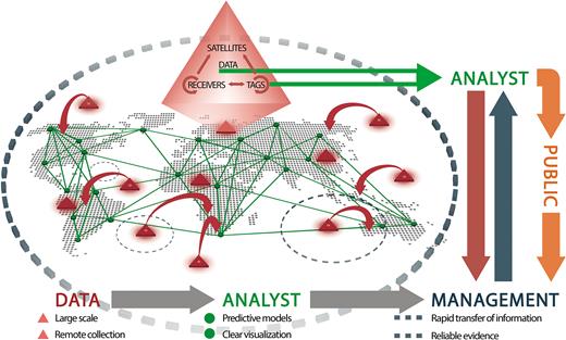
A schematic model of aquatic animal movement data creation. The red triangles illustrate how tags, receiver arrays, and satellite networks interact to generate animal movement data by logging it on the tag or transmitting it. Hybrids of these tags will be increasingly important components of aquatic animal telemetry, especially tags that can talk to each other (transceivers), tags that can log information and then offload it to receivers, and receivers that can communicate with land-based or satellite remote receivers. Deployment of these tag–receiver–satellite systems in aquatic ecosystems (red triangles) could then provide data to various nodes (i.e., scientific laboratories; green dots) worldwide. These data will contribute to management at various scales (local, basin wide, and global; see the dashed blue circles) and will aid in understanding basic aquatic ecosystem function while contributing to stock assessments, fisheries quotas, development of protected areas, and other management initiatives for conservation. This will be accomplished with significant interactions among stakeholders, with managers, scientists, and the public cocreating a research agenda that can be addressed by animal tracking data.
The technology deployed
The miniaturization and efficiency of tags will expand tracking to small species and early life stages
Apart from studies using PIT telemetry (Gibbons and Andrews 2004), the knowledge established using telemetry has almost invariably been predicated on the study of larger animals. This limitation principally results from the current sizes of sensors and, most importantly, batteries or electronics being too large to be carried by small-bodied animals. Individual movement and distribution data are therefore often lacking for smaller species and for early life stages (Wikelski et al. 2007). Smaller electronic components and more efficient circuitry design will continue to allow reductions in tag size without sacrificing tag longevity (e.g., Deng et al. 2015), and parallel advances in microbattery development will allow maintenance of power output with smaller cells (Wang et al. 2015). Better piezoelectric transducer design (Li H et al. 2015) has the potential to increase sound-transmission levels, augmenting acoustic tag range and expanding applications in noisy environments and deep-water ecosystems. Battery size may be further reduced and tag life prolonged through the development of tags powered by harvesting ambient energy sources such as solar energy or mechanical energy generated by the motion of the host animals (Li H et al. 2016). The refinement of file compression technology, onboard processing, and “smart” receivers that decide what data to record and when will facilitate the transition to smaller tags, such as data loggers switched on by depth changes or accelerometers switched on during periods of specific activity. The availability of smaller tags will not only enable research on small fish but will also be particularly important in expanding applications of telemetry to a wider range of invertebrates. PicoPIT tags (mass of approximately 10 milligrams) currently used in laboratory environments (e.g., for marking zebrafish as small as 0.2 gram; Cousin et al. 2012) will be combined with new developments in reader hardware to enable the remote detection of invertebrates and larval fish in the wild, at least in fresh water.
Animal location data will be more readily interpretable
Larger taxa can be tracked using satellite tags transmitting ultra-high-frequency radio (UHF). Positional data can also be obtained from postprocessed data (e.g., light-based geolocation data), currently transmitted by radio. However, most studies of individual aquatic animal spatial ecology use arrays of very-high-frequency radio (VHF; table 1), radio-frequency identification (RFID; especially passive forms, PIT), or acoustic receivers to derive real-time or postprocessed estimates of tagged animal locations. Omnidirectional hydrophone arrays can be used to estimate the position of an acoustic tag, such as by comparing the timing of sound arrival at multiple receivers to estimate the source location. With the advances in and reduced cost of high-performance computing, complex localization algorithms, such as approximate maximum likelihood (Li X et al. 2016), will be more commonly applied to improve tracking accuracy and increase the flexibility of array design. Open-source algorithms for such localization methods will encourage researchers to further develop the software, improving estimations of tag positions in 2-D or 3-D (Li X et al. 2016). The deployment of acoustic or radio arrays for elucidating habitat use requires a priori knowledge or hypotheses of where animals may move in order to efficiently and cost effectively design and establish arrays (Comfort and Weng 2014). However, for larger, wider-ranging animals or in instances in which receiver arrays are not feasible, positions can be estimated by using tags equipped with light-based geolocation, Fastloc GPS, or sensors to detect magnetic signatures or by using Doppler shifts detected by satellite (Hazen et al. 2012). Fastloc GPS and Doppler tags require the animal to break the surface, but light-based geolocation does not, provided that the animals are in the photic zone and reliable sunrise–sunset data can be recorded in situ. This is, in practice, a bigger problem in aquatic environments than in terrestrial ones, particularly given animal propensities to change depths. In theory, light-based geolocation sensors could be incorporated into acoustic tags that log data and relay it to acoustic receivers when animals pass to retrieve data. To increase the accuracy and precision of light-based geolocation, analytical tools such as state-space modeling and Hidden Markov models are being developed and applied to compensate for error that is inherent in using light levels to estimate position (e.g., Auger-Méthé et al. 2017). Advances in underwater geolocation will allow monitoring of a greater diversity of subsurface aquatic species, including those in habitats where installing receiver arrays is particularly challenging, such as in the open ocean and under ice. Light-based geolocation accuracy can be improved through the implementation of increasingly sophisticated position modeling algorithms and the incorporation of parameters such as magnetic field and oceanographic data (e.g., temperature; Nielsen et al. 2006). Additional refining of positions can be done by ground-truthing or the strategic deployment of Mark–Report satellite tags that are released from large animals, surface, and give a precise fix on the position of an animal at a given time.
Receiver platforms will be operationalized for detecting tagged animals
Receivers are traditionally deployed in strategic locations to detect transmitting tags, but the increased use of opportunistic or mobile platforms that receivers can be attached to, including fixed infrastructure, remote vehicles, and animal-borne biotrackers, will expand telemetry coverage. Much of this effort has so far focused on acoustic telemetry, but we anticipate similar developments with radio and PIT telemetry. Efforts to use various platforms for aquatic telemetry will reduce deployment costs, expand receiver coverage, and build stakeholder partnerships. Goulette and colleagues (2014) evaluated ocean observing buoys, fixed fishery gear, and surface drifters in the Gulf of Maine as platforms for receivers and found them to be useful for detecting a diverse suite of tagged species. Miniaturized animal-borne transceivers (e.g., Holland et al. 2009, Lidgard et al. 2014) attached to large-bodied animals (e.g., sharks, sturgeon, seals, narwhals, and turtles) provide a method by which to monitor acoustically tagged animals across large spatial scales while concomitantly documenting social interactions, intra- and interspecific competition, or predation. Mobile tracking can also be conducted by autonomous aerial vehicles (drones) flown over rivers to log radio transmissions or by hydrophones to detect acoustic transmissions, either deployed on marine autonomous vehicles (e.g., Slocum glider systems and Wave Gliders; Lin et al. 2017) or incorporated into dedicated vessels, such as fishing boats and on fish-aggregating devices (i.e., buoys). The harvesting of acoustic detections is also feasible from other sound-monitoring devices on appropriate frequencies deployed to record animal vocalizations (e.g., marine mammal passive acoustic recorders). Access to military passive acoustic monitoring in theory could further expand ocean acoustic telemetry coverage, but security issues currently prevent this.
Aquatic telemetry data will be available from remote offloading
Many applications of telemetry are limited by the need to manually offload data from data-logging receivers. In the future, significant gains will be made by developing alternative or enhanced methods for data acquisition through remote offloading. These include data transfer and storage between tags, between tags and satellites, between terrestrial and aquatic receivers, or between receivers and vessels or moored platforms (e.g., oil rigs), with the information ultimately being relayed to researchers (figure 1). Increasingly, acoustic tags will acquire improved data compression and acoustic modem transmission protocols. This will permit the download of archived positional data to acoustic receivers and the transmission of copies of data among large numbers of tagged animals (Holland et al. 2009, Lidgard et al. 2014), increasing the likelihood that the information will encounter cellular or relay modems that will deliver it to investigators (McConnell et al. 2004, Dagorn et al. 2007). In coastal regions, land-based relay receivers will enhance data throughput and improve the frequency of the detection of tagged animals (e.g., Lembo et al. 2002). Daisy chaining acoustic receivers so that they can communicate data along lines of receivers to a fixed station or satellite that transmits data from the entire array is also a possibility (Dagorn et al. 2007), but power management is an obstacle. VHF radio receivers are increasingly being networked to facilitate satellite data transfer. RFID-array data capture may similarly be transmitted by cellular network communication. The ICARUS (International Cooperation for Animal Research Using Space) initiative is emerging as a key player in animal tracking by equipping low-orbit satellites with receivers to detect small aerial or terrestrial tags on global scales (Kays et al. 2015). There are exciting possibilities for integrating these networks into aquatic animal tracking in the future.
The need to service receivers (e.g., replacing batteries and removing biofouling) adds expense to aquatic telemetry programs. Although battery technology is improving and reductions are being made in receiver power demands, short-term solutions to the power problem are available via integration of receivers into existing powered infrastructure. Plugging into underwater cables of observing stations such as the Ocean Networks Canada Victoria Experimental Network Under the Sea (VENUS; Taylor 2009) could facilitate long-term receiver deployments. Similarly, attachment to moorings fitted with solar panels (commonly used for fixed VHF radio and PIT tracking stations) may provide continual power to reduce the need for batteries. Autonomous power generation may become viable in the future by harvesting power from water flow or wave action (e.g., Hine et al. 2009), from pressure and temperature changes experienced during diving behavior, or by photovoltaic panels. However, advances in power sources do not solve biofouling that can impede receiver function (Heupel et al. 2008). Fortunately, the testing of materials resistant to biofouling is advancing (Shivapooja et al. 2015).
The data collected
Integrated and interdisciplinary approaches will enhance telemetry observations
Enhanced environmental (e.g., oxygen, conductivity, salinity, chlorophyll, and noise) and biological (e.g., blood chemistry and endocrinology; feeding physiology, including stomach acid or temperature; and mortality; see Cooke et al. 2016) sensor data collected by onboard electronic tags will provide accurate fine-scale measurements that give context for habitat use, movement, and intra- or interspecific interactions, facilitating predictive modeling. Miniaturized biosensors, such as those that measure blood metabolites (e.g., lactate anions; Rassaei et al. 2014), could transmit data from internal devices to externally attached tags for data archiving and subsequent transmission or be retrieved when tags are recovered. The expanded use of hybrid satellite and VHF transmissions will enable the physical recovery of integrated biomonitoring packages with large data archives (e.g., video, accelerometry, environmental, and physiological data).
Whenever an animal is tagged, the opportunity arises to do much more than simply deploy the tag. Contact allows for sampling or measurement of tissue or other biotic parameters. Further emphasis should be placed on collecting interdisciplinary data for greater insights into tracking information. In fish, a small muscle, blood, or gill biopsy can be used for physiological (e.g., cortisol, ions, lactate, and stable isotopes) or genomic analysis (e.g., relative up- or down-regulation of thousands of genes; Jeffries et al. 2014) to understand the status of the animal at the time of tagging. Molecular screening of those tissues can also be used to characterize the genetics of the individual or to assess disease state (e.g., identify pathogen expression; Jeffries et al. 2014). Tissues can be used to sex the organism, identify reproductive state or age structure (e.g., ovarian biopsy, fish-scale or spine analysis, pinniped whiskers, and marine bird feathers; Hansen et al. 2016, Lowerre-Barbieri et al. 2016), assess diet or energetic status (e.g., fatty acids, stable isotopes, trace elements, and microwave fat meter; Karnovsky et al. 2012), or quantify morphology (e.g., morphometrics by photographs). Animals can also be subjected to behavioral or personality assays prior to release in order to characterize life-history strategies and make inferences about the social structure of species (Krause et al. 2013). It will be increasingly important to combine novel types of measurements with telemetry data in order to assess cause–effect relationships among physiology or disease (Jeffries et al. 2014), behaviors, nutrition, or morphology (Hawley et al. 2016) to the fate and fitness of wild animals. Factors such as life history, morphology, personality, metabolism, and environmental context can be used to develop an understanding of vulnerability to fishing and the potential for fisheries-induced evolution (Villegas-Ríos et al. 2017).
Biologgers will tell us what animals are doing in the wild
The understanding of animal ecology will continue to improve with the broader application of biologgers incorporating probes to measure heart rate for physiology and energetics (Cooke et al. 2016), gut heating (i.e., digestion) and stretch (i.e., content or fullness), pH to infer feeding (e.g., Meyer and Holland 2012, Whitlock et al. 2015), or electroencephalogram activity to track brain activity when active or asleep (Rattenborg et al. 2008). The extension of biologging technology to RFID tags is possible, including thermally sensitive PIT and powered RFID tags with more complex physiological sensors and data-storage capacity (Volk et al. 2015). A combination of these approaches could be invaluable for understanding the physiological characteristics of swimming performance in restricted environments such as fishways and measuring animal physiology in environments such as aquaculture enclosures. Presently, the use of the data from many of the biologging tools that are being applied for monitoring and classifying animal behavior is limited without calibrations from direct observation. However, video recordings—in the laboratory (Carroll et al. 2014) or perhaps even remotely (Moll et al. 2007)—of instrumented animals can be used to identify behavior in the wild and cross-validated with instrument data by training machine-learning algorithms to identify repeated patterns (Carroll et al. 2014). This may be further refined by incorporating algorithms within tags to automatically process data and identify repeated behavioral patterns (e.g., feeding or copulation; Broell et al. 2013). Miniaturized waterproof action cameras are already used as a form of biologger, watching for activity or quantifying biotic contexts such as presence of competitors or predators (e.g., Takahashi et al. 2004). Given the importance of physically recovering biologgers from animals, improved locations from satellites and receiver platforms to detect the position of logging tags once they release is crucial for biologging technology to expand in scope.
The applications of telemetry data
The experimental design of telemetry arrays will aim to meet management and policy needs
With the growing demand for information on the spatial ecology of many aquatic organisms in spatial planning and conservation, telemetry users increasingly have a mandate to assist in the design of management or policy-relevant studies (McGowan et al. 2016). Moving forward, the most effective way to ensure actionable outputs is to include stakeholders at the initial design stages of a project's development (Young et al. 2013). To ensure the most effective and efficient experimental designs, especially with the increase in global acoustic telemetry infrastructure, development of regional telemetry networks will be imperative. Researchers will need to be informed on what equipment is already in place, and communication must be established with regional networks to avoid duplicated effort. The objectives of the investigation (see Cooke et al. 2012) will dictate the use of the available telemetry equipment in terms of receiver positioning and tagging distribution of focal species. The continued growth and development of the network approach to telemetry through regional, national, and international networks will facilitate and maximize the efficiency of experimental design. However, underpinning the aforementioned mission-oriented tracking will be the need for more hypothesis-driven studies using experimental approaches to understand questions that still elude us (e.g., how do animals navigate? Papi et al. 2000; what are the consequences of warming temperatures on migration? Crossin et al. 2008) but are also relevant to managers. To date, hypothesis-driven experimental design has only been made possible by the past three decades of telemetry studies that provide the necessary baseline movement data for some species.
Global networks will facilitate the development of data collection standards
In concert with coordinating infrastructure and managing extensive databases, global telemetry networks will be responsible for the standardization of data-collection practices as the foundation of large-scale aquatic telemetry studies. Network groups could provide standardized training for best practices in animal tagging, receiver array design, and data processing. The expansion of telemetry networks will both facilitate effective study replication and maximize the potential for efficiency and productivity within this area of research. Centralized information on attachment techniques for external tags will improve methods to reduce tagging effects and maximize data recovery, especially for tags that are required to detach from the animal, such as pop-up satellite tags (Jepsen et al. 2015). Guidelines for the assessment and monitoring of telemetry system performance, particularly important for receiver-based systems (e.g., Kessel et al. 2014, Huveneers et al. 2016), will facilitate effective study design and increase the accuracy of data interpretation. Data quality control is an area that will greatly benefit from universally accepted standards. For example, guidance is available to identify and filter false detections generated by coded identification systems and to remove false detections (Simpfendorfer et al. 2015). The development of standardized metadata collection and data-sharing protocols (see below) will facilitate easier data exchange among research groups. This will allow the development of universal database query tools and will greatly increase the willingness of independent research groups to search their databases for detections of other research groups’ study animals. The community could develop an international training program for aquatic telemetry to provide capacity and training to the developing world, especially in tropical nations, where the use of telemetry remains more challenging than in temperate regions (Baras et al. 2002).
Animal movement data will be widely shared and available
Telemetry use must undergo a quantum expansion to meet future knowledge needs for conservation and sustainable development. However, the expansion must keep costs affordable and share the burden of the costs among multiple partners. The most parsimonious way to document the movements and survival of tagged individuals at these large scales in the future is to share information about tag detections, use local expertise to maintain telemetry infrastructure, and provide internationally harmonized and accessible, quality-controlled, trusted data-sharing systems (Steckenreuter et al. 2016, Nguyen et al. 2017). Exponential increases in animal telemetry data (Hussey et. al. 2015) are driving the need for long-term, secure, trusted data systems, as well as analytical tools that can handle the challenges of complex data. Researchers may harbor concerns about data sharing (Crossin et al. 2017, Nguyen et al. 2017), but regardless, funders of telemetry research increasingly require that the data from studies they support be stored in publicly available databases (Nguyen et al. 2017). With presently available computer hardware and near-instantaneous World Wide Web communications, global telemetry data systems are feasible and developing. Existing regional telemetry networks will form the nucleus of the new global telemetry data system, which will become a quality-controlled, core biological ocean observing system of the expanding international Global Ocean Observing System. Open access to data, the sharing of data, and the building of a strong sense of collaboration among members are the next major steps, and these have already been accomplished to some degree within large telemetry networks at regional (e.g., the Florida Atlantic Coast Telemetry network, FACT), continental (e.g., Australia's Integrated Marine Observing System Animal Tracking Facility, IMOS ATF), ocean or freshwater basin (e.g., the Great Lakes Acoustic Telemetry Observation System, GLATOS), and global (e.g., the Ocean Tracking Network, OTN) scales (Hussey et al. 2015). Strengthening the commitments to these and other globally networked field and data systems will increase data availability, resulting in the increased research capabilities of individual investigators, augmented scientific productivity, greater international collaboration, efficient movement of knowledge to managers and decision-makers, the development of new data specialists that will mine information and the stimulation of new field programs enabled by the scale and scope of the global network.
Analysis and visualization will activate new knowledge
Aquatic telemetry data are diverse and range from simple presence or absence information to extremely high-resolution, complex, tortuous, and noisy time-series data that pose significant methodological and computational challenges. Furthermore, spurious or intermittent observations due to equipment failure, poor satellite transmissions, and other factors necessitate robust statistical tools. Fortunately, statistical approaches (e.g., state space models or Hidden Markov models) and open-source programming languages for statistical computing and graphics (R, www.r-project.org/about.html; Python) continue to be developed and applied to aquatic telemetry data (Auger-Méthé et al. 2017). This will be essential in order to realize the full potential of such data for addressing pressing scientific questions. In addition, as aquatic telemetry progresses, the numbers of personnel required to manage, analyze, and interpret the results will need to expand to match the huge amounts of complex data being gathered. Statisticians have a vital role to play and will need to be engaged at the project design phase to be truly effective in both experimental design and establishment of data collection standards. Collaboration among statisticians, computer scientists, and biologists will ensure that analysis and visualization tools with corresponding software are developed and advance in parallel with the technology. Telemetry networks (e.g., IMOS ATF, GLATOS, and OTN) are already developing and archiving code for processing and filtering detection data to make it readily available to new users. Currently, many of the key statistical tools are highly specialized, but their usability will improve as other researchers face similar analytical challenges and can more efficiently share and apply these techniques. The establishment, refinement, and popularization of the tools necessary for analyzing and reporting the findings of telemetry studies will facilitate the dissemination of results and the transition of knowledge into the hands of stakeholders.
Telemetry data will be a key informant of aquatic governance, policy, and management
One of the primary tools for fisheries management is predictive modeling, which uses data from various sources such as test fisheries, catch reporting, field observations, environmental conditions, and historical trends to generate predictions about population sizes and harvest possibilities (Dickey-Collas et al. 2014). Predictive modeling is also used in biodiversity conservation and species restoration plans. In the short term, telemetry research and data will help refine these models by contributing more information about animal behavior and interactions with other animals and the environment (Cooke et al. 2017a). In the next 10 years, aquatic telemetry will likely facilitate challenges to existing paradigms by identifying cryptic behaviors (e.g., Carroll et al. 2014, Whitlock et al. 2015, Filous et al. 2017) or species interactions (e.g., Lidgard et al. 2014, Gibson et al. 2015). The potential for contribution to management is significant because, for example, decisions regarding fisheries openings and harvest quotas can be made weekly, daily, or perhaps even hourly on the basis of real-time data on spatial location, behavior, breeding or spawning times, animal health, and mortality (Hobday et al. 2010). These should eventually include biologged, genomic, or environmental data (see Crossin et al. 2017). Faster collection and dissemination of animal population or fish stock trajectories will contribute to management decisions that help avoid overexploitation. For example, by monitoring the return of salmonids that were tagged as migrating juveniles to natal rivers, researchers can estimate the run size and set quotas to ensure sufficient escapement and to modify those decisions as new information accumulates throughout a season. Openly collected and widely shared telemetry data will improve the transnational regulation of fisheries and ecosystems by reducing uncertainty about the biological and spatial life course of fish and other harvested aquatic species. The effectiveness of marine protected areas can be evaluated (Filous et al. 2017), and candidate zones for new marine protected area designation will be easier to identify, even on the high seas. Telemetry data will help quantify the effectiveness of river connectivity restoration and encourage further experimentation in ecosystem recovery initiatives (Tummers et al. 2016). At the local stakeholder scale, telemetry research is often underappreciated and presumed to have little affinity to traditional forms of knowledge. User groups may express skepticism of predictive (population-level) modeling techniques, particularly when these models contradict their experience and their observations of actual fish and their environments (Bavington 2010). By contrast, when made publicly visible, telemetry tracks animals in their ecoenvironmental contexts, similar to the ways that local and traditional knowledge systems emphasize contextual observations. Through visibility, stakeholder support for telemetry should increase, thereby further enhancing its appeal to regulators.
Bridges will form between aquatic and terrestrial telemetry
To date, aquatic and terrestrial tracking studies have been largely evolving independently. However, both realms use similar technologies and produce related knowledge, and both face equivalent challenges and opportunities (Hussey et al. 2015, Kays et al. 2015). GPS satellites are shared by aquatic and terrestrial telemetry; however, GPS tags cannot communicate with satellites from under the water, so GPS technology is only possible for animals that breach the surface. Both realms are incorporating advanced sensor technology such as the use of fine-scale accelerometers (e.g., Carroll et al. 2014), physiological and genetic sensors (e.g., Fagan et al. 2013), and animal-borne cameras (e.g., Moll et al. 2007, Heaslip et al. 2012); both realms are also developing advanced data-management and -analysis tools. By integrating such endeavors, important new opportunities will be realized in “employing” animals carrying multisensor technologies as environmental monitors and for using data to develop effective and consistent conservation and management paradigms (McGowan et al. 2016). Bridging the realms of aquatic and terrestrial telemetry will enable the design of unified approaches and studies, the stimulation of novel ideas, faster evolution of the next generation of data analytics and visualization tools, the development of a community of practice on animal ethics, and cost–benefit analyses of the risks posed to an individual from capture and tagging compared with the benefits potentially gained from study results to conserve populations and habitats.
Looking forward
Telemetry expertise will shift beyond developed nations
Almost all the technological developments and continued innovation of telemetry have occurred in developed nations, resulting in the majority of telemetry expertise remaining in the developed world. Cultural ecology stresses the importance of local knowledge when conducting environmental research in developing countries; without the participation of local stakeholders, conservation cannot succeed. In addition, understanding the global ocean requires all regions of the globe participating. Therefore, the training of local people in their home countries and in the universities of developed countries is crucial (Batterburry et al. 1997). Training in developing nations is scarce, and the United Nations Food and Agriculture Organization has provided some initiatives, but these have had limited long-term impact (Baras et al. 2002). Opportunities from funding agencies for partnerships among researchers from developed and developing nations to participate in exchanges and engage in knowledge exchange, information sharing, and training must be sought out by the telemetry research community (Hall et al. 2001). Such opportunities will help grow the telemetry network at the global scale, break down barriers to its use, shift expertise to the developing world, and create diversity in both educational and work environments.
The environmental impacts of tags will be addressed. An important issue with the expansion of electronic tracking, both in terms of spatial coverage and in the numbers of animals tagged, is the environmental impact arising from the nonretrieval of potentially hazardous materials associated with large tags, especially batteries. The environmental impacts associated with lithium-ion (Li-ion) and lithium-polymer (Li-poly) batteries include toxicity associated with traces of cobalt, copper, nickel, thallium, and silver in the batteries (Kang et al. 2013). Systems that use biocompatible electrode materials with aqueous sodium-ion batteries could provide onboard energy sources, avoiding hazards both to the tagged animal and to the environment (e.g., using melanin from cuttlefish ink for battery anodes; Kim et al. 2013). Salt, paper, and algae- (Nyström et al. 2009) or sugar-based (Zhu et al. 2014) systems may also be developed, particularly for use in larger tags. For animals that spend time flying or sitting on the water (seabirds) or that haul out of water (turtles, seals, and penguins), new approaches to solar-recharged batteries hold immense promise for environmental compatibility.
Animal tagging methods will be optimized to minimize welfare impacts
Animals must be captured and often subdued (e.g., with chemical, electro-anaesthesia, or physical restraint) so that they can be tagged. Methods for immobilizing and subsequently reviving animals after capture or tagging are continuing to advance and include experimentally refined approaches designed to reduce behavioral deficits or physiological stress during the capture procedure and to accelerate recovery (Harcourt et al. 2010). Further refinement and testing of sedation methods that do not have withdrawal times, such as tetany in freshwater fishes induced by electricity (Trushenski et al. 2013) and tonic immobility in sharks induced by supination (Kessel and Hussey 2015), will continue to advance the applications of telemetry. The development of new methods for tagging animals is possible with guidance from veterinarians to improve the welfare status of animals that are tagged, which will also improve the representativeness of data collected from instrumented animals. Through education, the community should embrace novel tagging practices that further reduce bias in the data collected.
The technical challenges for determining animal fate will be overcome
Tags must provide accurate information about the animal, including interpretation of their postrelease fate, although at present, this remains challenging. Possibilities of tag expulsion by living animals can confound mortality estimates, and better understanding of species-specific retention is necessary to many studies (Jepsen et al. 2015). Electronic tags that cease transmitting or disappear from arrays may be inseparable from mortalities, limiting the power that analysts have to interpret data. Similarly, a tag that stops moving may indicate that an animal has died, reached its destination and is holding station (e.g., upriver migrating fish), or has become torpid (e.g., overwintering crustaceans). However, distinguishing these differing fates, without direct retrieval of the tag or observation of the tagged animal, may involve some error (Halfyard et al. 2017). These limitations could be resolved through such efforts as deploying test or control tags concomitant with a study and developing models that can distinguish small-scale movements of live animals from movements caused by water currents (e.g., Muhametsafina et al. 2014, Putman and Mansfield 2015) or that can identify depredation of tagged animals (e.g., Gibson et al. 2015). Activity sensors on tags have been used to identify mortality, and other biosensors can be integrated to assist in fate determination, including accelerometers, temperature loggers, or heart-rate loggers; there is even emerging tag technology that directly determines mortality due to ingestion into the stomach that may, if false positives can be solved or accounted for, be useful for separating predation from other causes of mortality (Halfyard et al. 2017). However, analytical tools will also be needed that can estimate the species of predator possibly on the basis of movement paths (e.g., Gibson et al. 2015).
Legal issues will continue to hover over data collection and management
A variety of legal issues will continue to challenge the future of aquatic animal tracking, such as the need to respect the privacy and confidentiality rights of resource users and the intellectual property rights of data collectors (Hobday et al. 2014). An issue likely to increase in importance is the uncertain legal status of data-collection technologies. A central question is how the marine scientific research (MSR) provisions of the United Nations Law of the Sea Convention relate to tracking of marine migratory species and the use of floats and gliders (Brown 2003, McLaughlin 2013). The convention, addressing MSR in Part XIII, requires coastal state consent for marine scientific research activities undertaken within a coastal state's territorial sea, within an exclusive economic zone, or on the continental shelf. Per Article 246 of the convention, coastal states must grant permission in normal circumstances with a few exceptions, such as where a project is of direct significance for the exploration and exploitation of natural resources, whether living or nonliving. For biologging, which bypasses the traditional method of MSR conducted from a dedicated research ship, a compelling argument exists that lack of independent human programming or control of animal movements removes the requirement for coastal state authorization (Kraska et al. 2015). The Intergovernmental Oceanographic Commission (IOC) has provided limited guidance regarding the deployment of floats and gliders but has suggested a simplified procedure for obtaining coastal state consents under the auspices of the IOC and for the deployment of ARGOS profiling floats (IOC 2008). A further legal issue is the liability rules applicable to cases in which an autonomous marine vehicle (AMV) collides with another vessel and the responsibility of the owner or operator of the AMV to avoid collisions at sea (Hobday et al. 2014). Similar issues described above are also possible in larger freshwater lakes (e.g., Laurentian Great Lakes) and rivers (e.g., Mekong River) that span jurisdictions, particularly as it relates to novel tracking data that have the potential to alter transboundary management governance, legislation, and management. Given the importance of aquatic animal telemetry research, these issues will require the consideration of researchers and funding agencies with an eye toward future resolution to permit advancement of the field.
Conclusions
As aquatic telemetry researchers, we have worked at the frontiers of aquatic animal research in marine and freshwaters around the globe, from under ice caps to tropical seas, from high-elevation mountain streams to the great lakes and rivers of the world, striving for novel solutions to challenging problems. In doing so, we have tested the limits of ourselves and of the available technology. Aquatic telemetry was established as a tool for science, management, and policy, but challenges exist with the assimilation and application of such data (VanderZwaag et al. 2013, Young et al. 2013). Environmental monitoring is now outpacing corresponding actions (McDonald-Madden et al. 2010), including how aquatic animal tracking is incorporated into management and policy (VanderZwaag 2015). This is a gap that must be bridged to maintain the relevance of aquatic telemetry. There are some troubling and unanticipated issues that have emerged (e.g., sabotage or questions about use of data for nefarious purposes; see Cooke et al. 2017b), and key stakeholders have at times been skeptical of observations derived from telemetry (e.g., Nguyen et al. 2012). Better communication of knowledge and evidence among scientists, stakeholders, regulators, and policymakers is necessary to ensure that the realized and envisioned scientific advances are used to make effective contributions to conservation and resource management (table 2). Demonstrating the utility of the data for management is essential, and effective knowledge transfer will also include efforts to make telemetry findings more accessible through clear and interpretable presentation.
This article looks into the future of aquatic telemetry in key areas related to technology and data, as well as its applications in aquatic science and governance, on the basis of perspectives from aquatic animal trackers, engineers, statisticians, legal experts, sociologists, and resource managers.
| Subsection of article | Take-home message for the future |
|---|---|
| The miniaturization and efficiency of tags will expand tracking to small species and early life stages | Miniaturize tags to suit small species and early life stages that remain poorly understood. |
| Animal location data will be more readily interpretable | Improve animal location precision with refined geolocation algorithms and greater input of ancillary data (e.g., temperature or magnetic field). |
| Receiver platforms will be operationalized for detecting tagged animals | Expand global receiver coverage by instrumenting various fixed and mobile platforms with receivers to increase our ability to detect animals. |
| Aquatic telemetry data will be available from remote offloading | Automate recovery of data from receivers by improving satellite communication and transmission with tags and receivers. |
| Integrated and interdisciplinary approaches will enhance telemetry observations | Integrate tag data with environmental, morphological, behavioral, and/or physiological data simultaneously collected from tagged animals. |
| Biologgers will tell us what animals are doing in the wild | Validate inferred behaviors derived from tag data on animals (e.g., movement, acceleration, and gut heat) that identify key life-history events, such as feeding, copulating, and migrating. |
| The experimental design of telemetry arrays will aim to meet management and policy needs | Collaborate with stakeholders to design studies that advance conservation or management through the cocreation of tagging experiments and monitoring. |
| Global networks will facilitate the development of data collection standards | Validate the replicability of telemetry experiments by communicating with and training animal taggers in best practices. |
| Animal movement data will be widely shared and available | Standardize data archiving and sharing to improve coverage and facilitate large-scale meta-analyses of movement trends. |
| Analysis and visualization will activate new knowledge | Collaborate between statisticians and biologists in consideration of the experimental hypothesis with foresight to the analysis. |
| Telemetry data will be a key informant of aquatic governance, policy, and management | Advance electronic tagging data to quantify vital rates in aquatic animals; estimate population sizes and harvestable surpluses; and evaluate management initiatives, such as restoration or area protection, with experimental design developed with stakeholders at the outset. |
| Bridges will form between aquatic and terrestrial telemetry | Share methods and technology and integrate studies for interecosystem evaluations. |
| Telemetry expertise will shift beyond developed nations | Develop skills and capacity to monitor aquatic environments in regions where conservation is emerging and access is limited or restricted. |
| The environmental impacts of tags will be addressed | Introduce tags powered by photovoltaic cells or with organic or biodegradable components. |
| Animal-tagging methods will be optimized to minimize welfare impacts | Refine tagging methods to increase the application of electronic tagging to new taxa and to ensure representative data from instrumented animals. |
| The technical challenges for determining animal mortality will be overcome | Integrate sensors and develop tools to identify the fate (e.g., mortality or depredation) of tagged animals from transmitted or logged data. |
| Legal issues will continue to hover over data collection and management | Establish agreements about remote data-collection technologies that cross jurisdictional boundaries along with responsibility for mishaps, such as collisions of autonomous vehicles. |
Note: Here, we review the take-home messages of each section of the review as a quick reference.
Continued technological advances in telemetry equipment and deployment designs will be an important catalyst for the future of aquatic animal tracking (table 2). At the same time, upscaling of data collection and analysis will facilitate answers to broadscale questions through hypothesis-driven experimental designs (table 2). Animal location data are now available for many different taxa around the world. Therefore, it is already possible to begin addressing questions about broadscale drivers of movement, comparing the relative importance of places and times with species and habitat conservation, and identifying areas where common threats and stressors emerge. Questions of such scale require cooperation and metadata sharing, but the capacity to answer even some of these huge global-scale questions represents opportunity and advancement for aquatic science (table 2). The growing ecosystem-based approach to aquatic science necessitates cooperation among nations, agencies, and scientists to extract the best insight from both new and existing telemetry data (Meeuwig et al. 2015). Establishing data-sharing conventions, including protocols for giving credit to those who contributed data, is necessary, or data transfer will likely break down, and knowledge advances will be lost. Local and global networks can work to address the concept of shared data, but there are still gaps that hinder the advancement of telemetry research. However, these gaps are starting to be bridged, signaling a promising future for aquatic science.
Acknowledgments
Financial and logistical support for this work were provided to the Ocean Tracking Network's Canadian and International Scientific Advisory Committee and the IdeasOTN synthesis working group through funding from the Canada Foundation for Innovation and the Natural Sciences and Engineering Research Council of Canada. Several authors are also supported by the Canada Research Chairs Program.
