


Abstract
The study investigates the physical impact of sediment deposition associated with aggregate dredging at a site off Dieppe, and the consequences for benthic fauna. Sampling stations were sited across potential zones of impact classified as high, moderate, and low deposition, depending on their proximity to dredging activities and their position relative to the net sediment transport route. Samples were also taken west of the dredge site outside the zone of likely impact (no deposition). A strong gradient was observed from the sediments dominated by fine sands in the high and moderate deposition zones, through to coarse sands and gravels in the low and no deposition zones. The benthic fauna sampled from the deposits of fine sand in the high and moderate deposition zones were sparse compared with the coarser deposits sampled from the low and no deposition zones. There was a strong correspondence between the distribution of different sediment fractions and the associated benthic fauna, with a weighted Spearman rank correlation of 0.638, higher than reported in related studies. This suggests that in deposition areas such as this, biological interactions play a less important role in shaping communities than the changes in the physical environment, which may have a greater impact on the biological communities.Desprez, M., Pearce, B., and Le Bot, S. 2010. The biological impact of overflowing sands around a marine aggregate extraction site: Dieppe (eastern English Channel). – ICES Journal of Marine Science, 67: 270–277.
Introduction
For many decades, land-based quarrying has played a central role in providing material for the construction industry. The resource is, however, finite, and with a move towards sustainable development, there is increasing requirement for the land-based resource to be supplemented with recycled aggregate and with material extracted from marine deposits. Marine aggregates are now widely used across Europe in beach nourishment and sea defence projects as well as for construction. In France, the industrial exploitation of marine material is in its infancy, with just 3 million tonnes being extracted annually, accounting for ∼1% of national aggregate production (ICES, 1992, 2001). In the UK, where dredging for marine sands and gravels has been established for some time, the yield is ∼13 million tonnes annually, equivalent to 6% of national aggregate production (BMAPA, 2008). The volume of aggregate extracted from the marine environment is likely to increase across the rest of Europe in future, as the industry evolves. Studies of the coastal deposits around France have estimated the volume of soft sediment available for extraction at 33 billion m3 (Augris and Cressard, 1984). Deeper water may provide further reserves of sand and gravel and, together with the coastal deposits, are likely to provide a source of aggregate for the future (ICES, 1992, 2001).
Several studies have been undertaken to evaluate the environmental effects of aggregate dredging on the fauna living in association with the deposits (De Groot, 1979; ICES, 1992, 2001; Van Moorsel, 1994; Kenny and Rees, 1996; Newell et al., 1998, 1999a; Desprez, 2000; Boyd and Rees, 2003). This area of research has historically focused on the direct effects of removing sediment from the seabed. More recently though, research has extended to include the indirect impact of overflowing sediments and the cumulative impacts of multiple extraction areas in proximity (Poiner and Kennedy, 1984; Norden Andersen et al., 1992; Newell et al., 1999a, b, 2004a, b; Desprez, 2000; Boyd and Rees, 2003; Robinson et al., 2005; Cooper et al., 2007).
During aggregate extraction, fine sediments are released with water in the overflow system and are sometimes released intentionally during screening, a process carried out to adjust the sand:gravel ratio to meet customer requirements. Where screening is employed, significant quantities of sediment may be rejected and returned to the seabed. The release of sediment during dredging increases turbidity in the water column, creating a sediment plume, the extent of which is dictated by the strength and direction of the prevailing currents and winds and the particle size of the material released. Settlement of these suspended sediments, often referred to as oversanding, can cause alterations to the seabed deposits as well as to the associated benthic fauna (Newell et al., 1999b, 2004b; Desprez, 2000; ICES, 2001; Boyd and Rees, 2003). Moreover, settled plume material can be resuspended and moved to other locations on subsequent tides. In the southern North Sea, areas of well-sorted fine sand extend up to 3 km from an active dredge site, reflecting the deposition and transport of material mobilized by the dredging and screening processes (Robinson et al., 2005). Even in strong tidal currents, the initial settlement of fine-sand-sized particles has been shown to take place within 5 km (Hitchcock and Drucker, 1996).
The current study, conducted between 1996 and 2001 in the eastern English Channel, investigates the effects of overflowing sands on the nature of seabed deposits and the associated benthic fauna. This source of impact is thought to be of particular significance in the eastern English Channel because the current velocities are strong, resulting in extensive dispersion of the sediment plume. The aim of the work was to improve our understanding of the physical and biological impacts of aggregate dredging, outside the boundaries of the extraction area itself. Such studies, carried out on small sites, will be of importance in estimating the potential impact of aggregate exploitation on a larger scale, particularly where screening is employed or where multiple dredging areas could exist in proximity.
Material and methods
Study site
The study area is located ∼8 km off Dieppe, on the French side of the eastern Channel (Figure 1), in water depths of 10–15 m (Lowest Astronomical Tide). The site corresponds to a pebble spit built up by littoral drift during the Pleistocene (Claveleau, 2007). Extraction activity, sedimentary, and biological context are described in Desprez (2000). The area is governed by a northeasterly residual tide from the English Channel to the North Sea, enhanced by frequent southwesterly winds. The amplitude of semi-diurnal tides is high (8 m maximum tidal range), and the tidal ellipse is rectilinear, parallel to the coast, aligned in a WSW–ENE direction (Anon., 1968). Pebbles are not mobile in the present hydrodynamic conditions, and they are overlaid with a thin mobile sand veneer. Tidal currents decrease from west to east, resulting in the sediment gradient described by Cabioch and Glaçon (1977) before the beginning of any extraction activity. Gravels with Amphioxus and sessile epifauna are found in the western sections, gravelly sands with Amphioxus in the eastern sections, and fine to medium sands with Ophelia 6 km to the east (Figure 1). Sands in the surroundings areas are dominated by 0.2–0.5 mm particles with a modal grain size of ∼0.35 mm (Augris et al., 2004).
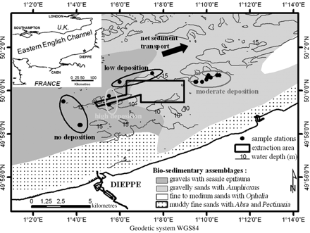
Location of the licensed extraction area and of the monitoring sampling stations grouped according to their expected level of deposition, superimposed on the main bio-sedimentary assemblages of the study area (after Cabioch and Glaçon, 1977).
Survey design and sampling
In all, 23 samples were collected as part of the ongoing environmental monitoring of the dredging site, between 1996 and 2001. Sampling stations were sited across potential zones of impact associated with the deposition of sediments released during dredging. These zones were classified as high, moderate, and low deposition, depending on their proximity to dredging activities (intensive dredging in the western corridor before 1995; extensive dredging in the present dredging rectangle since 1995, as described in Desprez, 2000) and on their position relative to the net sediment transport route (Figure 1). Two sites were also sampled to the west of the dredge site outside the zone of likely impact from dredging activity (no deposition). The latter sites provided reference data on the natural variability in the sediment deposits and associated fauna against which the impacts of oversanding could be assessed. Sampling was generally carried out in late winter, after a period when dredging activities usually cease, to prevent disturbance to herring during their spawning season (Anon., 1983). Two replicates were collected from each station with a van Veen grab (0.1 m2), and a subsample of sediment was removed for later particle size analysis. The remaining sediment was then pooled and washed over a sieve of 1 mm mesh to aid the sorting process, and the retained macrofauna was fixed in a 4% formaldehyde solution for later identification to species level and enumeration in the laboratory. The following classification was adopted for the sediment description purposes: gravel (>2 mm), coarse sand (2–0.2 mm), fine sand and silt (<0.2 mm).
Data analysis
Non-parametric multivariate analysis of community structure (Clarke, 1993; Clarke and Warwick, 2001) was used for both the sediment and benthic fauna data. The procedures, implemented in the software package PRIMER (Clarke and Gorley, 2006), have been widely used in the analysis of benthic community structure in European coastal waters (Warwick and Clarke, 1991; Clarke, 1993; Somerfield et al., 1995). Analysis of similarities (ANOSIM) tests, which are analogous to the traditional ANOVA test (Warwick and Clarke, 1991), were used to test for differences between the sediment and fauna sampled in the different zones of deposition. This test gives a test statistic (R) that ranges between −1 and 1, where 0 is equal to no difference, and values approaching 1 indicate a large difference between the sample groups. The value of R may also approach −1, but this is unlikely when examining community or sediment composition data because it would suggest that the groups are more similar to one another than the samples within the groups (Clarke and Warwick, 2001). A RELATE test was also carried out on species community data and the corresponding particle size composition of the sediments to test for a correlation between the two datasets. This test compares the multivariate patterns of two similarity matrices, in this case based on the square-root-transformed species abundance data, using the Bray–Curtis similarity coefficient and untransformed particle size data, using Euclidean distance (Clarke et al., 2006). Correlations were tested using the weighted Spearman rank correlation (pw), values of which lie in the range −1 (completely opposed) to 1 (complete agreement). Values close to zero indicate the absence of any match between the two patterns.
Results
Sediment distribution
Two-dimensional multidimensional scaling (MDS) ordination based on the particle size distribution at each of the stations sampled (Figure 2) shows that the samples group relatively well according to their predefined zones of deposition. Samples in the high and moderate deposition zones exhibit some separation, indicating a degree of inconsistency in sediment composition within those zones. Nevertheless, an examination of the sediment composition within these groups (Table 1) reveals an overall gradient between deposits dominated by fine sands and silts, sampled from within the zone of predicted high deposition, through sediments dominated by mixed-sand fractions, sampled from within the zone of moderate deposition, to the coarsest sediments, containing a significant proportion of gravel, sampled from within the zone of low deposition and from the reference stations (no deposition).
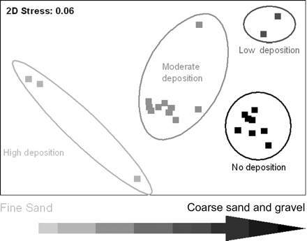
Two-dimensional MDS ordination based on the particle size composition at each of the 23 stations sampled between 1996 and 2001, offshore of Dieppe. Superimposed on the ordination are the predicted deposition zones from which the samples were taken.
Mean sediment characteristics of samples taken from within the four predefined zones of deposition next to an extraction area off Dieppe, France.
| Predicted deposition zone | Gravel (%) | Coarse sand (%) | Fine sand and silt (%) | Median grain size (mm) | Sorting (phi) | Skewness (phi) |
|---|---|---|---|---|---|---|
| No deposition | 28.5 (4.3) | 46.7 (5.6) | 24.8 (3.6) | 1.3 (0.2) | 2.2 (0.6) | 4.7 (2.2) |
| Low deposition | 53 (1.0) | 23.5 (0.5) | 23.5 (1.1) | 5.7 (2.0) | 2.8 (0.2) | 2.2 (0.9) |
| Moderate deposition | 6.5 (6.4) | 35.8 (2.6) | 57.1 (5.8) | 0.6 (0.1) | 1.5 (0.1) | 6.6 (2.9) |
| High deposition | 9.3 (7.7) | 11.3 (2.9) | 79 (10.5) | 0.3 (0.0) | 2.3 (1.4) | 7.1 (2.3) |
The standard error (s.e.) for each of the values is presented. Emboldened values correspond to the dominant sediment fractions.
Figure 3 shows the representative sidescan sonar images and histograms, demonstrating the average sediment composition of samples taken from within each deposition zone. There is a gradient from the coarser gravel sediments through to finer sand-dominated sediments in the areas predicted as having high levels of deposition. The no deposition reference stations are located in an area containing large sand dunes (visible on the sidescan sonar image; Figure 3), west of the licence area. Sediments from these stations correspond to gravelly sands (Folk, 1954) and are dominated by coarse sands (46.7%) and gravels (28.5%), with a complementary proportion of fine sands and silts (24.8%). Stations north of the licence area were expected to undergo only low deposition. The samples grouped roughly with the reference stations in the MDS ordination (Figure 2), because of the presence of gravel in both groups. Samples taken from the area, however, are strongly dominated by particles with a diameter >20 mm (Figure 3), indicating that the sites lie just inside the pebble spit described by Claveleau (2007). They correspond mainly to sandy gravels (Folk, 1954).
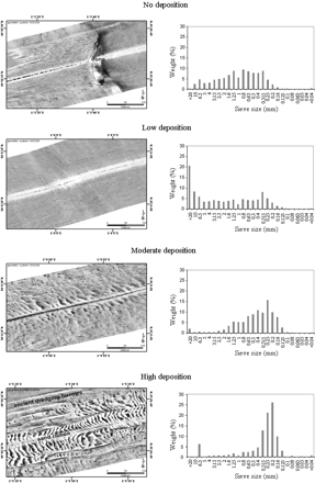
Morpho-sedimentary characteristics of the four main expected deposition zones of the extraction area off Dieppe, shown as sidescan sonar images and average grain-size histograms.
Sediments sampled from the moderate deposition zone were dominated by mixed sands and correspond mainly to slightly gravelly sands (Folk, 1954), forming large sand dunes (wavelength ∼10 m, orientated N–NW/S–SE; Figure 3). Sediments are dominated by fine sands and silts (57.1%) and coarse sands (35.8%). In the zone of predicted high deposition, ancient dredging furrows are covered in places by smaller sand dunes that are more closely spaced, organized in sand ribbons, which are visible on the sidescan sonar (Figure 3). These rippled sand ribbons result partly from natural sediment transport coming from the W–SW (coarse sands) and partly from sediments released during dredging (high content of fine sands). Before dredging activity started, Cabioch and Glaçon (1977) described the sediments in the predicted zone of high deposition as gravels with sessile epifauna, indicating that the deposits in the area may have undergone significant alteration in composition. With no data having been collected immediately before dredging, these changes cannot be confidently attributed to dredging, but the results do present strong anecdotal evidence that dredging activities are causing localized oversanding. Samples taken from the predicted zones of moderate and high deposition have a very large proportion (respectively, up to 50 and 70%) of fine sands between 0.16 and 0.315 mm, whereas in the reference sediments, this fraction does not exceed 25%. The sediment skewness values are also much higher in these zones (Table 1), another indicator of the increased fine-sand fraction observed in these samples.
An ANOSIM test was carried out to investigate the statistical significance of the differences observed in the sediment deposits under different levels of predicted deposition, the results of which are summarized in Table 2. These show that there is a strong and highly significant difference between the sediment composition recorded within the four different zones. The pairwise tests all gave very high values of R, indicating that the four zones are very different from one another in terms of their particle size distribution, but the differences between the high and low deposition sites were not significant (p < 0.5), which may be explained simply by the few samples that were taken in these two areas.
ANOSIM between the sediment composition of samples taken from within the four predefined zones of deposition next to an aggregate extraction site off Dieppe, France.
| Comparison | R statistic | Significance level (%) |
|---|---|---|
| All deposition zones | 0.792 | 0.1 |
| High deposition vs. no deposition | 0.968 | 0.6 |
| High deposition vs. low deposition | 1.000 | 10 |
| No deposition vs. low deposition | 1.000 | 2.2 |
| No deposition vs. moderate deposition | 0.851 | 0.02 |
| Low deposition vs. moderate deposition | 0.954 | 1.5 |
Distribution of benthic communities
In all, 173 species were identified from the 23 pooled van Veen grab samples. The numbers of infaunal species found within the samples ranged from 7 to 84, and total densities ranged from 22 to 776 individuals per 0.2 m2. The dog cockle Glycymeris glycymeris, the green sea urchin Echinocyamus pusillus, and the lancelet Amphioxus lanceolatus were the most common species, found at 80% of the stations sampled. Despite the common occurrence of these species across the stations, overall similarity between the faunal complements (based on Bray–Curtis similarity) was low (Figure 4). There is, however, a split of the fauna into two distinct groups at a similarity level of 20%.
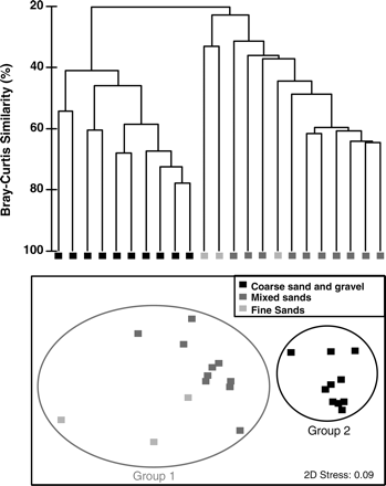
Group average sorting dendrogram showing the percentage similarity of benthic fauna and the corresponding two-dimensional MDS ordination for the 23 stations sampled between 1996 and 2001, offshore of Dieppe. Superimposed on the ordination are the predicted deposition zones from which the samples were taken.
The first group is more spatially separated on the MDS than the second, and corresponds to the samples taken from the predicted zones of high and moderate deposition. These samples were classified as fine sands and mixed sands, respectively, and as is typical in such sediments, the diversity and the abundance of benthic animals present are much reduced from the levels recorded in the coarser sediments (Table 3). The second and smaller group corresponds to the coarse sand and gravel samples taken from the predicted zones of no and low deposition. This group forms a relatively tight cluster on the MDS and has a relatively high internal similarity.
Average biological characteristics of samples taken from within the four predefined zones of deposition next to an aggregate extraction site off Dieppe, France.
| Predicted deposition zone | Number of species | Abundance (ind. m−2) | Biomass (g AFDW) |
|---|---|---|---|
| No deposition | 50 (12) | 2 394 (1030) | 12 (6.6) |
| Low deposition | 80 (4) | 3 906 (26) | 16 (2.1) |
| Moderate deposition | 28 (6) | 585 (282) | 5 (1.8) |
| High deposition | 18 (8) | 262 (107) | 1.4 (1.6) |
The standard error (s.e.) for each of the values is presented.
An ANOSIM test was carried out on the faunal data to investigate the statistical significance of the differences observed at the different levels of predicted deposition, the results of which are summarized in Table 4. As observed in the same test carried out on the granulometric data, the overall value of R was high (0.792), and the result was highly significant (p = 0.001). The pairwise tests show, however, that this difference is not common between all groups. The fauna identified in the no and low deposition zones are not significantly different from one another, demonstrating that the differences in sediment composition between the two sites did not affect the associated faunal complement. The zones predicted as being subjected to high and no deposition showed the greatest difference in faunal composition, corroborating the results of the MDS (Figure 4).
ANOSIM between the benthic community composition of samples taken from within the four predefined zones of deposition next to an aggregate extraction site off Dieppe, France.
| Comparison | R statistic | Significance level (%) |
|---|---|---|
| All deposition zones | 0.792 | 0.1 |
| High deposition vs. no deposition | 0.995 | 0.6 |
| High deposition vs. low deposition | 1.000 | 10 |
| High deposition vs. moderate deposition | 0.654 | 1.4 |
| No deposition vs. low deposition | −0.151 | 68.9 |
| No deposition vs. moderate deposition | 0.94 | 0.01 |
| Low deposition vs. moderate deposition | 0.926 | 1.5 |
Animal–sediment relationships
Superimposition of the broad deposit classification on the two-dimensional MDS ordination of benthic fauna illustrates the close correlation between biological communities and sediment composition (Figure 4). The relationship is investigated further by plotting the percentage of key sediment fractions, gravel (4 mm), coarse sand (1.6 mm), and fine sand (0.2 mm), alongside the relative abundance of selected characterizing species in Figure 5. These species were identified as the greatest contributors to the internal similarity of the two faunal groups in a SIMPER analysis carried out on the faunal abundance data.
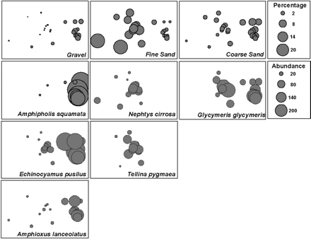
Relative values for the percentages of gravel (4 mm), coarse sand (1.6 mm), and fine sand (0.2 mm) superimposed on the two-dimensional MDS of the benthic fauna recorded offshore of Dieppe between 1996 and 2001. Also shown are the relative abundance of selected species which characterize the benthic communities, identified through SIMPER analysis of the raw abundance data.
The coarse sand and gravel community, mainly associated with the 4-mm gravel fraction, is characterized by the dog cockle, the green sea urchin, and the lancelet. All three of these are typical species of coarse sand, and their presence can be taken as an indicator of the significant sand content even in the coarsest deposits in the area. Dog cockles were also abundant in the mixed-sands group dominated by the 1.6-mm coarse-sand fraction. The faunal community identified in these deposits is also characterized by the catworm, Nephtys cirrosa, and the bivalve, Tellina pygmaea. Samples taken from the deposits of fine sand close to the active dredge site have a less diverse faunal complement, characterized by the polychaete Spiophanes bombyx.
The two faunal communities identified are also different when considering the biomass; the bivalve Arcopagia crassa is the dominant species in the coarse deposits, accompanied by other characteristic species such as the green sea urchin and the bivalves Venerupis rhomboides and G. glycymeris. The bivalve Spisula elliptica dominates the fauna identified in the deposits of fine sand in terms of biomass, along with the catworm and the crab Thia scutellata. Species such as the bivalve G. glycymeris, the polychaete Lumbrineris sp., and the lancelet are dominant across the whole area, further demonstrating that the fauna of the area does not exist as distinct, unrelated communities, but rather overlaps with other fauna on a gradient associated with the sediment composition.
To test the statistical significance of the observed relationship between the fauna and sediments, a RELATE test was carried out on the species abundance and sediment composition data, the results of which reveal a strong correlation, R = 0.638, between the multivariate patterns observed in the sediment and faunal data, which is highly significant (p = 0.001).
Discussion
Evidence from a number of studies shows that dredging can lead to sediments becoming finer, particularly where screened material is returned to the seabed (Robinson et al., 2005; Cooper et al., 2007).
Spatial extent of deposit sands
Sand discharged back to the seabed as overspill falls back to the seabed to be re-entrained by natural tidal processes. This deposition of sediment on the seabed is an example of a secondary impact, often extending outside the permitted area. In the southern North Sea (Newell et al., 2004b), discharged sediment is moved by the tidal stream to form a footprint measuring ∼4000 × 900 m of better sorted sand of finer grain. The evidence presented here indicates that the area of deposition in Dieppe may extend up to 2 km away from the eastern limit of the dredging site; a similar distance was detected in a discontinued aggregate extraction site in the southern North Sea (Robinson et al., 2005), under similar current conditions (rectilinear tidal ellipse, maximum spring tidal current velocity reaching 1.5 m s−1, near-bed residual).
In a review of research conducted before 1997, Newell et al. (1998) concluded that there was little evidence that deposition of sediments from outwash during the dredging process had a significant impact on the benthos outside the immediate dredged area. However, more recent evidence, including the work cited above for sediment granulometry, suggests that the biological impact may extend outside the immediate vicinity of the dredged area and correspond to the “footprint” of sediment deposition and transport along the axis of tidal streams. In this study, we found a significant reduction in diversity (number of species) and abundance associated with sediments containing high levels of fine sand. A causal relationship can only be implied through a lack of pre-dredge sediment data, but this does imply that the impact of overlying sediment could be in the same order as impacts caused by dredging itself (Desprez, 2000), and that the impacts may extend up to 2 km in the direction of residual tidal currents, as reported in similar studies elsewhere (Kenny and Rees, 1996; Boyd and Rees, 2003; Robinson et al., 2005).
Animal–sediment relationships
One of the most commonly encountered scenarios in the aftermath of marine aggregate extraction is a shift in the substratum from sandy gravel to gravelly sand (ICES, 2001), the extent of change being dictated by the dredging intensity and whether unwanted sand is returned to the seabed following screening. Where sand is overlaid on coarser sediment, the impact is likely to be worsened because some elements of the community are sedentary in nature and may possess little ability to withstand smothering. The benthic fauna colonizing the deposits also will reflect the change in substratum, with an increase in the proportion of sand-dwelling vs. gravel-dwelling fauna, and a net decline in faunal biomass and abundance, as observed in the fine-sand deposits in this study. It is a natural expectation that faunal biomass will remain reduced as a consequence of oversanding because the fine material will be more easily disturbed by tidal currents, maintaining the community at an early-successional stage (Kenny and Rees, 1996; Paphitis et al., 2000).
An increase in the proportion of fine sand in deposits following aggregate extraction has been reported frequently (Desprez, 2000; ICES, 1992, 2001), and it can be associated with a change in the type of fauna that re-colonizes the deposits (van der Veer et al., 1985; Desprez, 2000; Van Dalfsen et al., 2001). This suggests a strong relationship between sediment composition and the associated fauna. This study corroborates this, although others have found the relationship to be less clearly defined (Seiderer and Newell, 1999). In this study, the sediments were very sandy and relatively homogeneous, compared with deposits targeted for extraction in the North Sea (Seiderer and Newell, 1999). Where sediments are more heterogeneous and contain pebbles and gravel, biological interactions are likely to play a more significant role in shaping communities. This is because coarser sediments can support a wider variety of species, including those which are epilithic (Seiderer and Newell, 1999). Sand-dwelling organisms are for the most part truly infaunal (Van Dalfsen et al., 2001) and, because sand deposits are by their very nature more homogeneous, they are unable to support the same diversity as mixed gravelly deposits, reducing the possibilities for biological interaction (Newell et al., 1999a; Seiderer and Newell, 1999). It is unsurprising then that marine fauna show a stronger relationship with sediment composition in sand-dominated deposits.
The Dieppe study site can be considered a key research area to provide empirically grounded models for physical and biological responses to commercial aggregate extraction in other sandy areas. The results of the study allow the validity and generality of experimental results to be established in sand-dominated dredge sites (Boyd and Rees, 2003). Further work will of course be required in other localities exhibiting different environmental conditions to validate these results fully. It will also be important, looking forward, to establish the implications for such dredging-related impacts on the wider marine foodweb.
Acknowledgements
We thank Alain Delorme (GIE Graves de Mer) for providing the opportunity to develop specific monitoring surveys and for his permission to cite the data reported here, Xavier Harlay and Nicolas Desroy (IFREMER) for preliminary statistical treatments, and especially Richard Newell for helpful discussions and suggested improvements to the manuscript.
