


Abstract
Data from the ocean-colour monitor (OCM) on board the Indian Remote Sensing Satellite P4 were used to analyse the spatial and temporal distribution of aerosol optical thickness (AOT) over the coastal and offshore waters of the eastern Arabian Sea. Zero water-leaving radiance from the near infrared (NIR) region was assumed for oceanic (open ocean) waters, because of the absorption of long-wave radiation by water molecules. As this assumption fails in coastal waters, it was necessary to correct for water-leaving radiance and sun glint to the NIR bands. The aerosol size-distribution parameter (α) was derived from a relationship between two NIR bands. The Ångström turbidity parameter (β) was obtained using an algorithm relating in situ hand-held, sun-photometer measurements and aerosol radiance (La) at 490 nm. The relationship between β and La (490) was derived with a sensitivity analysis, using a calibrated radiative transfer model. AOTs were retrieved for each pixel of 500 nm. The algorithm's performance was tested by comparing OCM-derived AOT values with in situ AOT and MODIS-derived values. Aerosol maps thus generated from January to December 2005 demonstrate the potential of this new retrieval method for producing AOT climatology from OCM data over coastal waters.Menon, H. B., Sangekar, N., Lotliker, A., Krishna Moorthy, K., and Vethamony, P. 2011. Aerosol optical thickness and spatial variability along coastal and offshore waters of the eastern Arabian Sea. – ICES Journal of Marine Science, 68: 745–750.
Introduction
The atmosphere above the North Indian Ocean is subject to aerosol radiative forcing resulting from seasonally reversing summer (southwest) and winter (northeast) monsoon winds. Several Indian programmes have been initiated to understand the direct and indirect effect of these aerosols on climate. Analysis of data from the Indian Ocean Experiment (INDOEX, 1997–1999; Ramanathan et al., 2001) revealed northeast monsoon winds as the main agent transporting anthropogenic aerosols over the Arabian Sea. These aerosols, unlike natural maritime aerosols, not only scatter incoming solar radiation, but also absorb it (Satheesh and Ramanathan, 2000; Eck et al., 2001; Li and Ramanathan, 2002) and augment the greenhouse effect. This disclosure motivated an extensive field campaign, the Integrated Campaign for Aerosols, Gases, and Radiation Budget (ICARB) in 2006 (Krishnamoorthy et al., 2008). The combined effect of natural and anthropogenic aerosols could contribute to atmospheric and ecological imbalances in the eastern Arabian Sea. This underlines the need for a synoptic understanding of the atmosphere over the eastern Arabian Sea, including the Ångström turbidity parameter (β), aerosol-size distribution parameter (α), and subsequently aerosol optical thickness (AOT), a quantity required for determining aerosol radiative forcing at the top of the atmosphere.
The role of aerosols in climate change remains uncertain. Although the theory behind their effect on outgoing terrestrial and incoming solar radiations is well understood, spatial and temporal variability make it difficult to assess their magnitude with in situ observations. Satellite remote sensing is the only means of providing the synoptic coverage needed for analysing aerosol radiative forcing at the top of the atmosphere. Rajeev and Ramanathan (2002) discussed the spatial distribution of AOT over the open ocean (Arabian Sea and Bay of Bengal) at a spatial resolution of 1.1 km, using data for the 630-nm band of Advanced Very High-Resolution Radiometer (AVHRR) on board the National Oceanic and Atmospheric Administration (NOAA) satellite. However, an analysis of the small-scale features associated with aerosol distribution over optically complex areas, such as the coastal waters of the eastern Arabian Sea, requires sensors with higher temporal and spatial resolution. The ocean-colour monitor (OCM) on board the Indian Remote Sensing Satellite (IRS) P4 provides spatial and temporal resolutions of 360 m and 2 d, respectively. Previous attempts to retrieve AOT from OCM data over the eastern Arabian Sea (Das et al., 2002; Dey et al., 2004; Chauhan et al., 2009) assumed that sensor radiance of NIR bands resulted entirely from atmospheric backscattering. However, this assumption holds only in oceanic and not in turbid coastal waters. The current study aims to formulate a technique to derive AOT from OCM over coastal waters and to demonstrate the method's potential for analysing aerosol distribution along the eastern coastal Arabian Sea. In a fisheries context, these AOT values could be used to estimate aerosol radiance as a part of the complex atmospheric correction procedure, resulting in more accurate values of chlorophyll a.
Material and methods
Study area and data collection
The AOT over oceanic and coastal regions of the eastern Arabian Sea (Figure 1), including the estuaries of Mandovi and Zuari (Goa, India), was studied as part of the Indian Space Research Organization's Geosphere Biosphere Programme. Oceanic observations were obtained from the RV “Sagar Kanya” in an area bounded by 14°20′–22°35′N and 65°–73°34′E during the period 4–18 December 2004. Coastal waters were surveyed by the RV “Sagar Purvi” from 23 to 28 November 2004. Six estuarine surveys were conducted using a fishing vessel on 12 February, 18 March, 13 April, 11 May, 11 November, and 9 December 2005.
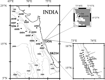
Map of the study area showing the in situ sampling locations and depth contours. Main panel: oceanic observations, RV “Sagar Kanya”; top inset: estuarine observations, fishing trawler; bottom inset: coastal observations, RV “Sagar Purvi”.
A Microtops II hand-held sun photometer, with bands at 380, 440, 500, 675, and 870 nm, was used to measure AOT (full field view of 2.5°). A global positioning system interfaced with the Microtops II provided accurate time and position of each station. During all field surveys, AOTs were measured between 09:00 and 16:00 at 30 min intervals, in association with the IRS P4 satellite pass (12:00). This provided a total of 210, 78, and 90 observations for the oceanic, coastal, and estuarine surveys, respectively.
Predetermined stations (Figure 1) for in situ observations were located between depths of 30 and 1000 m (8–700 km from shore) to prevent water-pixel contamination from land radiance. Profiles of downwelling irradiance and upwelling radiances were obtained with a Satlantic in-water radiometer at all stations. In addition, surface water samples were collected to determine the concentration of optically active substances (OASs), including suspended organic matter (chlorophyll a), inorganic matter (sediment), and chromophoric dissolved organic matter (CDOM), using methods described by Menon et al. (2005). Radiometer measurements and water-sample collection were carried out simultaneously from the sunlit side of the ship to avoid any discrepancy in the computation of water-leaving radiance resulting from a change in the sun's zenith angle.
Generation of α and β from in situ measurements

OCM characteristics and data processing
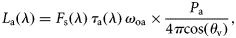
OCM data from the IRS P4 satellite were analysed to retrieve AOT. OCM has eight bands; six visible and two near infrared (NIR), centred at 412, 443, 490, 510, 555, 670, 765, and 865 nm. The first six bands are used for analysing the OAS (ocean-colour components) in the water column and the remaining two for measuring path radiance (aerosol and Rayleigh radiances) to apply atmospheric correction for ocean-colour analysis. The spectral resolution of the visible and NIR bands are 20 and 40 nm, respectively.
Images were georeferenced using ground control points and the study area was extracted using image processing software. During the months November–January, because the aerosol plume builds around 22°N, two OCM images were processed to include the area between 10 and 23°N. For the other months, only one image, covering the area between 5 and 20°N, was processed. Cloud cover prevented analysis of aerosol parameters during the period June–August. To validate the AOT retrieval method from OCM further, AOTs derived seasonally from OCM pixels over oceanic waters (8–15°N) were compared with AOTs from MODIS. This comparison was made between the mean of nine adjacent pixels of AOT from OCM and the corresponding pixels of MODIS.
Aerosol retrieval from OCM data

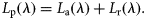


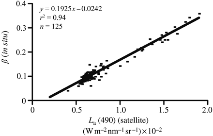
Regression between in situ β (Ångström turbidity parameter) and satellite-derived La 490 (aerosol radiance at 490 nm).
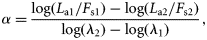
Nine OCM images (10 January, 12 February, 18 March, 11 April, 11 May, 20 September, 6 October, 25 November, and 12 December 2005) were then processed to retrieve α and β parameters. The Ångström (1961) equation was then applied, and AOTs and α at 500 nm were mapped.
Validation
In all, 150 observations (90, 45, and 15 from the RV “Sagar Kanya”, RV “Sagar Purvi”, and fishing vessel surveys, respectively) were used for validation of satellite-derived values. Each pixel contained more than one in situ value. Hence, averages of α and β were compared with the mean values of the adjacent nine pixels in the satellite imagery. To avoid possible land interference (estuarine width decreases upstream), only those observations taken at the mouth were considered for validation.
To authenticate the method further, AOTs derived seasonally from OCM cloud-free pixels in an open-ocean region between 8 and 15°N (not in the area of in situ observations) were compared with AOTs from MODIS. MODIS has a 550-nm band; consequently, AOTs from OCM-derived α and β at 550 nm were used for the comparison.
Results and discussion
Validation
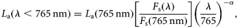
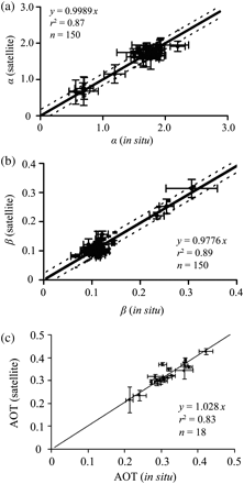
In general, OCM-derived products and in situ observations are in good agreement and in the same range (Figure 3a–c). In particular, there was good agreement between satellite-derived and in situ AOT values (Figure 3c). The confidence level, RMS error, and mean difference bias were computed for this relationship, and were 95, 2.267, and 0.965%, respectively. Moreover, the zero offset and slope close to unity supports the accuracy of the retrieval. There was also good agreement between OCM- and MODIS-derived AOTs during the pre-monsoon (February–May), end of monsoon (September), and post-monsoon (October–January) seasons (Figure 4a–c).
Correlation between (a) satellite- and in situ-derived α (aerosol size distribution parameter), (b) satellite-derived and in situ β (Ångström turbidity parameter), and (c) satellite-derived AOT and in situ values for validation. Dotted lines in (a) and (b) are the 95% confidence levels, and vertical and horizontal bars the s.d.
Correlation between AOT at 550 nm derived from OCM and MODIS for (a) pre-monsoon, (b) monsoon, and (c) post-monsoon seasons.
Aerosol distribution
The spatial distribution of satellite-derived AOT during the months January–December (Figure 5a) reveals an inter- and intraseasonal variability over the study area. AOT is significantly higher during the pre- (January–May) than in the post-monsoon (September–December) season. Aerosol plumes originating at the western margin of the Indian subcontinent extend deep into the offshore region during the pre-monsoon, with AOT ranging from 0.2 to 0.5.
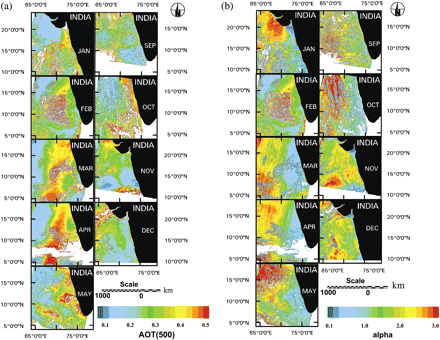
Spatial distribution of (a) AOT at 500 nm, and (b) α derived with OCM data for 10 January, 12 February, 18 March, 11 April, 11 May, 20 September, 6 October, 26 November, and 10 December 2005.
A low AOT (0.15) in the northeastern region and a high AOT (0.4) along the coast between 15 and 20°N are significant features during January. AOT values increased farther offshore during this month, and by February formed an offshore aerosol plume. Except for this localized plume, aerosol distribution was spatially uniform (∼0.3) in February. During March, aerosol in the inshore region around 20°N 72°E increased, and the offshore plume strengthened further. Three hotspots were then evident, one inshore and two offshore, all orientated northeast–southwest in narrow plumes. By April, these had merged into a single elongated plume with the same orientation. By May, this plume had dissipated into patches of intermittent low and high values along the coast and offshore. Examination of wind patterns from NCEP/NCAR reanalysis data (a joint product from the US National Centers for Environmental Prediction and the National Center for Atmospheric Research) revealed that the northerly winds during January had changed to northeasterly by April, suggesting that changes in wind direction caused these changes in aerosol distribution. During winter, strong northeast monsoon winds maintain a vertical moisture gradient by bringing dry, continental air over the eastern Arabian Sea, so allowing continued intense evaporation (Prasannakumar et al., 2001). This results in increased atmospheric humidity and subsequent atmospheric convection. Increased humidity increases aerosol particle size because of hygroscopic growth (Im et al., 2001). This augments scattering, resulting in increased optical thickness. This process might cause the high AOT (0.5) values at the plume's core. In their studies, Li and Ramanathan (2002) noted that AOT is high over both the Arabian Sea and the Bay of Bengal during the northeast monsoon. They observed aerosol plumes over the Arabian Sea and attributed them to the advection of continental anthropogenic emissions. Similar results were obtained in a study examining the role of synoptic and mesoscale weather patterns on aerosol spectral optical depths and size characteristics at a coastal industrial site in India (Niranjan et al., 2004).
The aerosol pattern during May could be explained based on changing wind direction. The Findlater Jet (also known as the Somali Jet) originates around 10°S and progresses northwards as the southwest monsoon advances. It then becomes southwesterly to westerly while crossing the equator (Menon, 1989), intensifying by May and beginning to blow from the African continent in a southwesterly–westerly direction, resulting in the observed redistribution of aerosol along the coast. Studies in the southern Arabian Sea demonstrated that during May, southwesterly–westerly winds bring mineral dust from Arabia and North Africa (Li and Ramanathan, 2002). The type of aerosol over the study area is indicated by the temporal distribution of the aerosol size distribution parameter (α; Figure 5b). Low values of α and the large optical thickness along the coast clearly indicate enhanced loading of mineral dust aerosols during May compared with earlier months. However, this could be supplemented by coarse mode marine aerosols generated and transported by westerly winds, which increase as the monsoon approaches.
The removal of aerosol because of widespread monsoonal rains from June to August depletes the AOT by September. Wind patterns are intermediate in October, during the initial phase of the transition from southwest to northeast monsoons. This causes an uneven distribution of aerosol along the coast during October (Figure 5a). By the end of November, northeast monsoon winds become more unidirectional, resulting in the concentration of aerosol off 22°N 68°E (Figure 5a). Although AOT decreases gradually towards the south, a patch of aerosol with AOT = 0.5 is seen around 7°N, which could be attributed to sea-salt aerosol. In their studies, Li and Ramanathan (2002) indicated an enhancement in the production of sea salt because of wind. In December, the wind pattern becomes uniform and the plume seen off 22°N and 68°E further strengthens and concentrates in a northeasterly–southwesterly direction.
Conclusions
In a fisheries context, satellite remote sensing of phytoplankton biomass and its temporal and spatial variability in Indian coastal waters are essential to the country's potential fishing zone programme and other initiatives in fishery oceanography using ocean-colour data. However, to obtain the accurate measurements of chlorophyll a as an index of phytoplankton biomass from an optical sensor, corrections for atmospheric effects need to be implemented. The current study develops a new algorithm to retrieve aerosol parameters α and β from OCM to compute AOT over coastal turbid waters. These AOT values can be used to estimate aerosol radiance as a part of the complex atmospheric correction procedure resulting in more accurate chlorophyll a values.
Acknowledgements
We thank the Indian Space Research Organization for funding the project under the IGBP programme, and Prof. Dilip Debgaokar, Vice Chancellor, Goa University, for his encouragement.
References
Author notes
Present address: Indian National Centre for Ocean Information Service (INCOIS), Ocean Valley, Hyderabad - 500 055, India.
