


Abstract
Under its Conservation Credits scheme to reduce cod mortality, the Scottish Government has implemented a system of real-time closures (RTCs) since 2008. These are relatively small, temporarily closed areas (50–225 square nautical miles per RTC, closed for 21 d) that are triggered by high cod catches. An important step in evaluating their effectiveness is to determine the response of vessels to RTCs, because the conservation benefit would be reduced if vessels moved to areas of greater cod abundance following closures. Abundance indices from research-vessel surveys and commercial-vessel observer trips are combined to create a time- and space-dependent relative cod-importance index (RCII). Vessel monitoring system data from Scottish vessels fishing during 2008/2009 are used to construct RCII profiles for each vessel, which are then used to determine whether the areas to which vessels move have a higher or a lower RCII, and how far away they move when an RTC is activated. We show that the RCII of the areas moved to tends to be lower than that of the RTC and that vessels travel farther when moving away from a closure than when moving back after reopening. Although not conclusive, this result indicates that RTCs may impact beneficially on cod mortality.Needle, C. L., and Catarino, R. 2011. Evaluating the effect of real-time closures on cod targeting. – ICES Journal of Marine Science, 68: 1647–1655.
Introduction
Scientific advice for fishery management has always been based on limited data. Catch data often do not include discards, and survey indices are derived from brief snapshots of stock abundance and distribution. Such limitations often hamper the ability of scientists to help managers to take appropriate decisions. Historically, one of the key missing pieces of information has been the location of fishing effort. Without good data on where vessels have been fishing, it has been very difficult to devise and implement appropriate management measures that take account of the spatial distributions of fish or fleets.
Although not without problems, the recent availability of vessel monitoring system (VMS) data to scientists has permitted a wide range of analyses that would not previously have been possible (see, e.g. Lee et al., 2010; Vermard et al., 2010; Gerritsen and Lordan, 2011). The example considered in this paper is the response of Scottish skippers to the implementation of real-time closures (RTCs), which are part of the Scottish Government's response to European Union (EU) calls for reductions in cod (Gadus morhua) mortality. Using VMS data and a derived spatio-temporal distribution indicating the relative importance of cod, we analyse the movements of those vessels thought to be most directly affected by RTCs. Specifically, we determine whether vessels moving away from closed areas (or back towards reopened areas) increase or decrease their likely impact on cod mortality, as measured by the RCII (relative cod-importance index) in the areas in which they are fishing. Although the analysis is useful in itself for evaluating the impact of management measures on cod mortality, it is also valuable as an example of how to use fishery-dependent information to provide management advice that would not otherwise be obtainable.
Data
Since 2003, monitoring systems of the VMS type have been installed on Scottish fishing vessels longer than 15 m, ostensibly with two main purposes: to assist in search-and-rescue operations and to enable compliance officials to know where a vessel was at a given time (and whether it was transgressing in closed areas, for example). The potential value of VMS data to scientists studying fleet behaviour and producing stock assessments was clear immediately, but permission for Scottish fishery scientists to access VMS data was granted by the Scottish fishing industry only in 2007 (Gatt and Reid, 2007). Since then, scientists from government laboratories (Marine Scotland) have been allowed to use such data for research purposes. However, such access is limited to studies concerning the Common Fisheries Policy (CFP) of the EU and associated issues.
VMS data consist of vessel speeds, headings, and locations, with one reading (known as a “ping”) being transmitted to a central repository via a satellite link every 2 h. The data are actually generated at a much higher frequency (as much as once every 10 s), but the limitation to one ping every 2 h reduces the cost of satellite transmissions. Even at this frequency, there are often periods of missing data in the VMS database; these transpire for various reasons, principally faulty equipment. The database used for this study contains VMS records for all Scottish non-pelagic vessels (>15 m) fishing during the period specified.
Restrictions on the use of VMS data
Dissemination and transmission of Scottish VMS data to the public are not permitted. The Freedom of Information (Scotland) Act does not apply, because VMS data are considered to be sensitive personal information and are protected under EU law. However, it is important to note what are and what are not considered to be VMS data. The term is intended to cover data that identify individual vessels and reveal their speed, position, and heading while at sea. Our interpretation of recent legal advice indicates that suitably anonymized plots of vessel positions and speeds are not VMS data and can be included in publicly available documents.
In this context, it is important to be able to generate plots that summarize a vessel's position and speed in a way that does not reveal its identity or exact fishing location, because this is commercially sensitive information that would be illegal to present. Standard plots of VMS positions are not appropriate for this purpose. In this paper, a system of data binning is used to present VMS information at a suitable level of aggregation. However, the analyses are carried out using exact-position 2-h VMS ping data, so the accuracy of vessel positions is not compromised.
VMS data do not indicate directly what a vessel is doing at a particular location. Borchers and Reid (2008) used probabilistic activity models to conclude, for demersal trawlers, that only those moving at speeds of 0.5–5 knots were likely to be fishing. Recent analyses comparing VMS and closed-circuit television data from Scottish vessels support this speed range (unpublished results), and it is used by the Scottish Government when determining areas to be closed. VMS fishing pings in the analysis here are therefore specified using the same speed criterion.
RTCs during 2008–2010
As part of its Conservation Credits initiative which began in 2008, the Scottish Government instigated a series of RTCs intended to divert demersal fishing effort away from areas of abundant cod, and hence to reduce cod mortality. The RTCs were stipulated as areas of ∼50 square nautical miles and were initially defined as 7 × 7 nautical mile squares,, although this limitation has subsequently been relaxed and RTCs may now be of different shapes. Since June 2010, the maximum possible area of each RTC has been increased to 225 square nautical miles. Each RTC is in place for 21 d, following which period they are reopened automatically. Further, the rules limit the number of RTCs that can be enacted simultaneously in proximity to prevent certain local fishing communities being unfairly disadvantaged. The closure of an area is triggered by an upper limit on the observed cod density, defined as 40 cod (of any size) per hour's fishing. Notification is via skipper's logbooks, monitored landings, or by on-board observation, and a single high-density haul is sufficient to instigate a closure. There may only be a maximum of 11 closures defined by logbook or landings data in operation at any one time, along with an additional three closures defined by positive on-board samples. Since 2009, observance of RTCs by Scottish demersal fishing vessels has been mandatory. There is no legal impediment to vessels from other countries fishing in RTCs, although they have been encouraged by the Scottish Government and the EU not to do so, and anecdotal evidence from compliance officers and the Scottish fishing industry suggests that RTCs have generally been respected by non-Scottish vessels.
Full details on how RTCs are defined within the Conservation Credits scheme are given in Holmes et al. (2009): see also European Parliament (2010). In all, 15 such closures were implemented in 2008, but an expansion of the scheme led to 144 closures in 2009 (Figure 1a) and 165 in 2010. Although the area covered by the closures in 2009 looks substantial, it is important to note that only a few of the RTCs were in force on any given day: Figure 1b shows the extant closures on 1 July 2009.
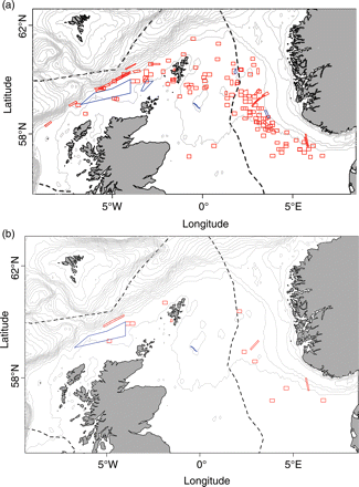
Area closures in (a) the whole of 2009, and (b) on 1 July 2009, showing both RTCs (red), and permanent or other seasonal closures (blue; see Holmes et al., 2011). The dotted line shows the extent of the UK EEZ, and grey lines show bathymetry at 100-m intervals.
Cod abundance data
To generate a spatio-temporal distribution of relative cod importance, and thereby to determine whether vessels moved towards or away from cod as a result of the area closures, reliable data on observed cod densities were required. Reported landings have limited utility for this purpose, because they do not include discards, which may be a sizeable component of the catch, and they are not very informative about where the fish were caught. The reported landings for a fishing trip might be assigned equally to all the VMS fishing-ping locations for that trip (see above), but this is imprecise and could be misleading. Appropriate models of fish distribution incorporating landings records are under development, but for this exercise, we considered that landings data could not be used for the analysis. The data used, therefore, come from a combination of research-vessel surveys and discard observations. For 2008 and 2009, they were: Data were taken from the ICES DATRAS database (www.ices.dk) and the Scottish Fisheries Management Database (FMD) operated by Marine Scotland (www.scotland.gov.uk). The locations of cod observations for the period May–August 2008 are summarized in Figure 2.
the North Sea International Bottom Trawl Survey (IBTS-NS, Q1 and Q3), carried out by several countries during the periods January/February and July–September and collated by ICES;
the Beam Trawl Survey (BTS Q3), conducted in the southern North Sea during August and September and also collated by ICES;
the Scottish Groundfish Survey in Division VIa (West of Scotland), carried out by Marine Scotland on RV “Scotia” during March (ScoGFS VIa Q1);
the Scottish Rockall survey (Rockall Q3), conducted by Marine Scotland on RV “Scotia” during September;
Scottish discard observations, collated from ∼75 observer trips each year.
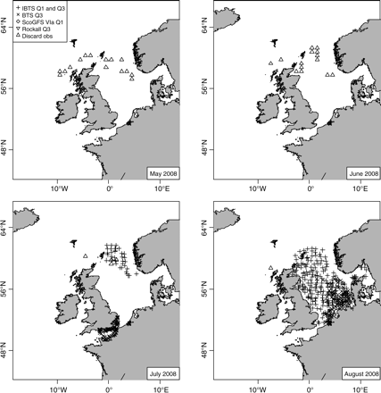
A subset of the cod-density observations used to generate the relative cod-importance index (RCII). Symbols indicate the locations of available observations for the period May–August 2008. Note that these dates do not include the ScoGFS VIa Q1 or Rockall Q3 surveys.
Methods
The relative cod-importance index
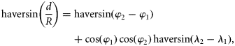
To determine whether vessels moved to areas of greater or lesser cod density when displaced by the creation of an RTC, we developed an index of relative cod density (the relative cod-importance index, or RCII). In brief, it takes all available spatial distribution data on cod from research-vessel surveys and discard-observer trips for a given month, standardized to a consistent scale (the measurement units used by different surveys and observer programmes can vary widely), then fits a trend surface using generalized least squares. The procedure produces a contour plot of relative cod importance for each month. However, observations in a given month can be patchy; and for some months, there are no observations at all, so to improve the consistency of fitted distributions through time, there is an additional temporal-smoothing step in which the distribution at each point for a given month is modified by the equivalent values in preceding and succeeding months. Temporal smoothing is achieved using weighted local polynomial regression (loess) smoothers (Cleveland et al., 1992), in which the weights are the Haversine distance (see below) from the point in question to the nearest points with actual observations in that month. Therefore, we generate a relative cod distribution using observed abundances, smoothed over both space and time to avoid problems inherent in the patchiness of the data. These analyses were carried out using R (version 2.8.1; R Development Core Team, 2008), with the “spatial” library (Venables and Ripley, 2002).
The RCII algorithm proceeds as listed below.
The numbers of cod N caught per hour (by either a survey or an observed vessel) are extracted from the relevant datasets. Cod numbers from each data source are heavily skewed, with many zero observations and a few large ones. If used without any transformation, these data would lead to cod distribution maps consisting of a few hotspots, a pattern that does not reflect the industry perception of a widespread cod abundance on which fishing decisions are based. As we are attempting to model the consequences of such decisions, results based on non-transformed data would have little relevance. To improve the distributional properties of the data for the purposes of this analysis, therefore, a cube-root transformation N1/3 is applied. However, the choice of transformation is ad hoc: zero-inflated models (Zuur et al., 2009) would be examples of plausible alternatives.
The data are further rescaled so that the relative abundance over all observations for each source lies between 0 and 1 (considering all months together), avoiding problems with the original very different measurement units. This rescaled abundance is denoted by Ñ1/3.
Abundance data from all sources are collated into a single dataset, then split by month. The R function used to fit trend surfaces (see below) will fail if two or more observations have exactly the same position. To prevent these computational problems, small random perturbations are applied to the latitude–longitude position records of all observations.
The dataset for a given month now contains a list of rescaled abundances along with a unique latitude–longitude position marker for each. The R function “surf.gls” is used for each month to generate trend surfaces based on Ñ1/3 values. This approach assumes a heteroscedastic error structure in the underlying abundance distribution. As part of the fitting process, a mask is applied to ensure that land (depth < 0 m) and deep-water areas (depth > 250 m) are excluded from the fitted distribution, because cod are unlikely to be found in either. An example is given in Figure 3 (for January 2008).
The next step is to apply temporal smoothing through a weighted loess regression time-series smoother. Weights are calculated using the mean inverse-Haversine distance of the point of interest (xi, yi) to the n available abundance observations for that month (see below).
The final step is to use all the smoothed index values for each month to generate a new smoothed-density map for that month.
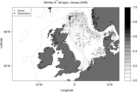
Fitted trend surface (without temporal smoothing) for rescaled cod abundance Ñ1/3 for January 2008. Grey lines indicate the 250-m depth contour, used to limit the study area. Darker areas indicate higher values of Ñ1/3. Open circles, data points from research-vessel surveys (in this case, IBTS NS Q1); closed circles, data from observer trips on commercial vessels.
The intention with this weighting scheme is to produce an estimate for a given point in a given month that depends strongly on nearby observations and is only weakly determined by distant observations. These weights are then used in a weighted loess smoother, which in addition to the monthly values includes the mean of the time-series as extra values in months 0 and 25, i.e. at the ends of the time-series. These extra values are given a weight of 0.5 each in the smoother and are intended to prevent potential extrapolation to negative values. The span of the loess smoother is set to 2.0, following exploratory analyses which indicated intuitively that this gave a reasonable balance between responsiveness and smoothness.
Generation of RCII difference metrics and distances moved
Given a spatio-temporal RCII, the next task is to determine those vessels which would be expected to be affected by RTCs. The full VMS dataset for 2008 and 2009 was partitioned by vessel. The VMS data for each vessel were then examined to determine if: For each trip in which one of these criteria was met, the mean RCII for all VMS fishing ping locations during the trip was calculated. For cases A and B, the mean fishing-ping RCII for the following trip undertaken by the vessel was calculated; for case C, the mean fishing-ping RCII for the preceding trip was calculated. The mean RCII for the trip of interest was then compared with that from either the preceding or the following trip (the comparison trip), as appropriate. If the RCII for the trip of interest exceeded that for the comparison trip, it would indicate that the vessel had moved to an area of less importance for cod following the closure, although we cannot conclude that the closure was necessarily the reason for the move.
the vessel had been fishing within an RTC area during the 15-d preceding closure;
the vessel had been fishing in an RTC during the closure;
the vessel had returned to the RTC area during the 15-d following reopening.
We also calculated the geographic midpoint of all the fishing pings for the trip of interest and for the comparison trip. The Haversine distance [Equations (1) and (2)] between the two VMS midpoints was used to approximate the distance moved between the areas fished in the two trips, and therefore how far the vessel had moved following the closure (cases A and B) or the reopening (case C).
Results
An example of the results of the weighting scheme for the RCII for a point east of Shetland is shown in Figure 4a. Figure 4b gives the smoothed time-series for the example point, showing some evidence (although not strong) for a decline in RCII for this example point through the study period. Figure 5 then gives the full result of the RCII algorithm for January 2008. The overall impression is of a cod distribution that is concentrated around the northern reaches of the North Sea, which is similar to what would have been expected from knowledge of survey data and the locations of good fishing grounds.
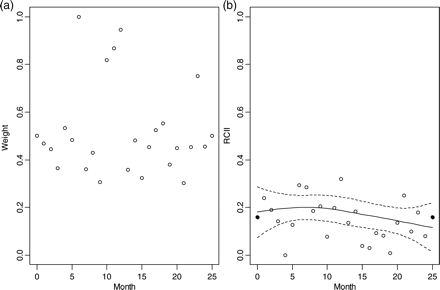
(a) Mean Haversine-distance weights for temporal loess index smoothing at a point off the east coast of Shetland, for 2008/2009. (b) Monthly relative cod-importance index (RCII) for 2008/2009, along with a weighted loess smoother (solid line) with 95% confidence limits (dotted lines). Solid points in months 0 and 25 indicate the means of the full time-series, which were included in the smoother estimation (with weights of 0.5) to prevent unrealistic boundary estimates.
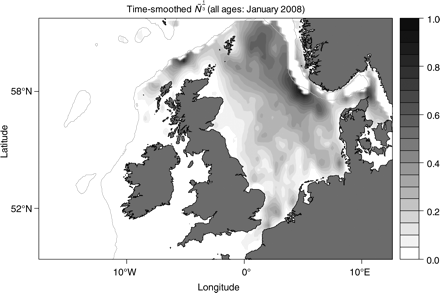
Fitted trend surface (with temporal smoothing) for rescaled cod abundance Ñ1/3 for January 2008. Grey lines indicate the 250-m depth contour used to limit the study area. Darker areas indicate higher values of Ñ1/3.
Figure 6 summarizes the VMS data for a particular vessel (vessel X) from two successive trips during 2009. Fishing effort during the first trip was focused on the western edge of the Norwegian Deeps, with some fishing also in the region of the Long Hole seasonal closure. During that first trip, vessel X fished (according to its VMS pings) in an area which became RTC number 1 (for 2009) during the following week (Figure 6a). Although it cannot be assumed that it was a report from vessel X that triggered the closure, it can be concluded that vessel X was operating in that area. The VMS data from the same vessel's next trip show that fishing was concentrated in the Shetland area (Figure 6b). The mean RCII by fishing ping from the first trip was 0.509, whereas that from the second trip was 0.378. The median distance between trips was 339 km, so, in summary, vessel X was fishing in an area that was subsequently closed. It moved a considerable distance on its next trip and fished in an area which (according to the RCII) was less important for cod.
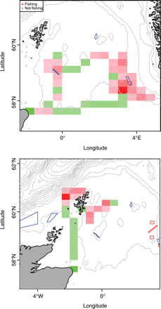
Aggregated VMS ping positions for vessel X during two consecutive trips in 2009. Aggregation bins are 0.5° × 0.25° rectangles, shaded by ping abundance (darker colours indicate more pings). Note that only fishing pings are included in the scaling for those bins with both fishing and non-fishing pings. Red polygons indicate RTCs; blue polygons show permanent or other seasonal closures.
Without consulting the skipper concerned (if indeed he could recall the trips), the precise reasons for this move cannot be known. There may have been many good reasons other than the closure for the shift in fishing area. However, such comparisons can be used to characterize the changes in fishing areas around the closing or reopening times of RTCs.
Figure 7 summarizes two quantities for all 403 Scottish vessels in the available VMS database that were observed to move away from RTCs following closure (case A): the difference in RCII between the trip preceding the closure and the trip following it (left panels), and the distance moved between the two trips (right panels). The results are presented here as histograms covering each quarter (Q1–Q4) in 2009. The mean RCII difference was negative (meaning that vessels moved away from cod following a closure) for three of the four quarters of the year, and the distances between trips was greatest during the first quarter.
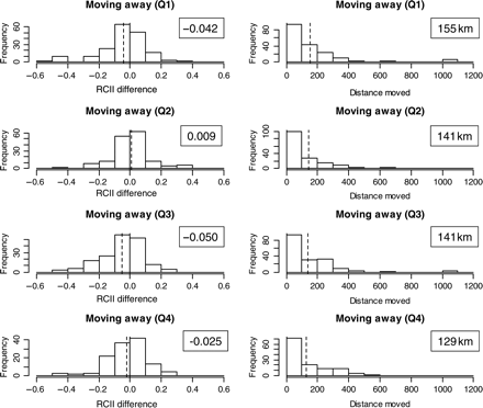
Example histograms of results from VMS analyses for 403 Scottish vessels in 2009. Only case A (moving away from an area after it is closed) is included here. Pre- and post-closure trips are compared in terms of (left panels) the difference in mean relative cod importance index for fishing pings, and (right panels) the distance moved (km). The four quarters of the year (Q1–Q4) are presented separately. The dashed vertical lines and the boxed numbers show the means.
The mean RCII difference does not in itself indicate whether the movement away from cod was statistically significant. Table 1 summarizes the results of t-tests for whether the mean RCII difference was significantly different from zero, for the whole year and for each quarter of 2009. In addition to the results covered in Figure 7, Table 1 also considers those cases in which vessels fished in RTCs while they were closed (case B) and moved back into RTCs after reopening (case C). Over the year as a whole, there was statistically significant (at the 95% level) movement away from cod following RTCs. Significant negative mean RCII differences can be seen in the first, third, and fourth quarters. The positive mean RCII difference in the second quarter could have indicated movement towards cod, and indeed anecdotal evidence from the industry suggests that this may have happened following concerns over catch-composition rules. However, the Q2 value is not significantly different from zero, so firm conclusions cannot be drawn. In terms of what can be determined for case A (moving away from RTCs after closure), it would appear that the movements were generally away from cod. This also holds for case B (fishing in RTCs during closures), although there are few records in this category (only 16.1% of all RTC interactions in 2009) and they are likely to have arisen from vessels which were not fully subject to the RTC scheme. The fishing areas of vessels in the Conservation Credits scheme are closely monitored, and there are strong disincentives to fishing in RTCs. There is significant evidence for an increased RCII when vessels return to RTCs after reopening (case C), overall and for all quarters except the first. These results suggest that RTCs encourage vessels to move away from cod-important areas when they are closed, but do not necessarily discourage renewed fishing on cod when they are reopened.
Differences between mean relative cod importance (density) index values for pre- and post-closure trips of Scottish trawlers, for the whole of 2009 and for each quarter thereof (Q1–Q4), and for each of the three cases (see text for details).
| Period | Before (case A) | During (case B) | After (case C) |
|---|---|---|---|
| 2009 | −0.028* (p < 0.001) | −0.033* (p < 0.001) | 0.035* (p < 0.001) |
| Q1 | −0.042* (p < 0.001) | −0.042 (p = 0.169) | 0.005 (p = 0.774) |
| Q2 | 0.009 (p = 0.411) | 0.000 (p= 0.982) | 0.026* (p = 0.009) |
| Q3 | −0.050* (p < 0.001) | −0.081* (p < 0.001) | 0.050* (p < 0.001) |
| Q4 | −0.025* (p = 0.031) | −0.024 (p = 0.155) | 0.051* (p = 0.001) |
p-values of pairwise Student's t-tests carried out to determine whether the values are statistically different from zero are given in parenthesis: significant differences (at the 95% level) are shown by an asterisk.
Finally, Table 2 reports the means of the distances moved between consecutive trips during 2009 and each quarter thereof, and for each case (A, B, and C). On average, vessels moved further when displaced away from closing areas (case A) than when moving back into reopening areas (case C), which may indicate more deliberate efforts to change the fishing area immediately following a closure. The distance moved following closures (case A) decreased through the year, whereas that following reopening (case C) tended to increase, so that by the fourth quarter, the mean case C distance was actually greater than the mean case A distance.
Means of the median distances (km) moved by Scottish trawlers between consecutive trips around closure periods for cod, for the whole of 2009, for each quarter thereof (Q1–Q4), and for the three cases (see text for details).
| Period | Before (case A) | During (case B) | After (case C) |
|---|---|---|---|
| 2009 | 142.6* | 164.5* | 120.7* |
| Q1 | 155.2* | 154.5 | 76.5 |
| Q2 | 141.2 | 206.1 | 129.6* |
| Q3 | 140.5* | 151.4* | 118.1* |
| Q4 | 129.4* | 114.1 | 135.1* |
| Period | Before (case A) | During (case B) | After (case C) |
|---|---|---|---|
| 2009 | 142.6* | 164.5* | 120.7* |
| Q1 | 155.2* | 154.5 | 76.5 |
| Q2 | 141.2 | 206.1 | 129.6* |
| Q3 | 140.5* | 151.4* | 118.1* |
| Q4 | 129.4* | 114.1 | 135.1* |
Cases and quarters for which relative cod importance indices between fishing grounds were significantly different at the 95% level (Table 1) are marked by an asterisk.
Conclusions
VMS data have been used in previous studies of the effects of closed areas, but have tended to focus on such aspects as descriptions and models of effort distribution near closures (e.g. Murawski et al., 2005), or the potential impacts of effort redistribution from large, permanently closed areas (e.g. Dinmore et al., 2003). We have considered a rather different problem and have used VMS data and an estimated spatio-temporal RCII to evaluate whether vessels moved away from cod-important areas following the imposition of RTCs in 2009. The results suggest that some avoidance of cod-rich areas following closures did indeed transpire in the first, third, and fourth quarters of that year, but no firm conclusions can be drawn about the second quarter. It would also appear that there was some movement back towards cod-rich areas following the reopening of RTCs. Consequently, we suggest that the RTCs in 2009 did reduce overall cod mortality while they were closed, but that they may not have had any longer-lasting effect on cod exploitation patterns.
However, there are several caveats with the analysis that must be borne in mind. The RCII is at an early stage of development and may not be sufficiently detailed to permit robust evaluations of fleet behaviour at the scale of the small RTCs implemented in 2009. The use of three separate smoothing operations is rather cumbersome, and the spatial scale of the results is perhaps too broad for purpose. We note also that the resultant monthly RCII is deterministic, and does not account for model uncertainty. However, the results reported in this paper do concur with what would have been expected given our experience of survey data and the fishing industry, so we suggest that the method presented here is fit for purpose for the time being.
The patchiness of research-survey and discard-observation data suggests that the RCII should be considered as a minimum estimate of cod abundance, although firm conclusions on this hypothesis are not yet possible. Model-based methods to generate spatio-temporal distributions for cod and other species, taking account of uncertainty and additional information such as depth, are currently being developed, although these will only ever be as good as the data on which they are based. We have assumed in this paper that the data are fully representative, and of course this is open to debate. VMS pings of 2 h may have insufficient resolution to track fishing activities, and the assumed relationship between vessel speed and fishing operations may not apply universally.
Equally importantly, for reasons of tractability we have limited our analysis to those vessels observed to be fishing in the area of RTCs that were subsequently closed (case A), or while closed (case B), or after reopening (case C). We did not attempt to draw any conclusions about the rest of the fleet, which may also have changed behaviour as the result of RTCs, although we cannot tell yet whether this did or did not benefit the cod stock. Moreover, we cannot yet determine whether the movements of the evaluated vessels were unusual. Vessel X (Figure 6) may have intended to fish around Shetland on that second trip anyway, regardless of the implementation of a closure. To address this issue, it will be necessary to track the fishing patterns of specific vessels for longer than a single year, to improve the estimation of cod distribution (and extend it to other relevant species), and to investigate the socio-economic factors that determine the underlying drivers behind changes in fishing location.
This paper should be viewed, therefore, as a first step in an ongoing analysis. The conclusion that vessels generally moved away from cod following the RTCs in 2009 is robust, given the information used and the assumptions made, but should not necessarily be considered as the final result.
Acknowledgements
We thank Neil Campbell (previously Marine Laboratory, Aberdeen) for collation and provision of VMS data, and editor David MacLennan and two anonymous reviewers for valued comments on an earlier draft of the paper.
