


Abstract
An exhaustive analysis of historical sea-level records at three stations located along the northern and northwestern Spanish coast has permitted a description of the mean sea-level trend over the past 67 years. The analysis also produced results on the type, amplitude, and propagation of tides, as well as on the range of variation in the sea level, extreme values, and return periods. Once corrected for the Post Glacial Rebound, the rise in the mean sea level was estimated at 2.38, 2.45, and 2.65 mm year−1 in Santander, A Coruña, and Vigo, respectively. The meteorological contribution is evaluated by the winter North Atlantic Oscillation index, producing a correlation of −0.658 with the empirical orthogonal function mode 1, which explained 81.86% of the total variance of winter (from December to March) mean sea levels. Harmonic analysis evidenced the semi-diurnal nature of the tide and showed that the amplitude and propagation of the M2 tidal wave followed the North Atlantic regional pattern, with decreasing amplitudes and phases from east to west. Hourly height levels were run through an extreme analysis and resulted in maximum sea-level values over the respective mean sea levels (datum): 2.55, 2.48, and 2.51 m in Santander, A Coruña, and Vigo, respectively. The estimated extreme levels for a 120-year return period exceeded the observed maxima in the three locations by 0.25, 015, and 0.10 m, respectively.García, M. J., Tel, E., and Molinero, J. 2012. Sea-level variations on the north and northwest coasts of Spain. – ICES Journal of Marine Science, 69: 720–727.
Introduction
The sea-level surface varies constantly because of tides, atmospheric pressure variations, and wind, and as a result of the associated effects of these meteorological disturbances, such as waves and eddies. The variation in ocean volume associated with water density changes, the thawing of continental glaciers and polar caps, or local rises attributable to river discharge are also responsible for sea-level variations, as are tectonic movements. However, in time-scales from several hours to several years, measured variations in the sea level, referring to a land benchmark, are mainly the result of tides and are a response to atmospheric forcing.
Sea-level measurements are required for a wide range of scientific, commercial, and practical applications: determining the reference level in terrestrial and nautical cartography; maritime navigation support; public works; engineering projects; and coastal management. Moreover, in recent years, the concern about global climate change has fostered coordination between national and international authorities of sea-level measurement systems because of their relevance as indicators of climate change and to document the vulnerability of coastal areas to trends and variations in sea levels locally (e.g. lowlands prone to sea-flooding and coastal erosion).
At present, several groups of experts and scientists are analysing the dataseries of the Permanent Service for Mean Sea Level (http://www.psmsl.org). Despite discrepancies in the criteria and algorithms used for the analysis, the Fourth Assessment Report (AR4) of the Intergovernmental Panel on Climate Change (IPCC, 2007) agrees that over the period 1961–2003, the mean sea level rose by 1.8 ± 0.5 and 1.7 ± 0.5 mm year−1 throughout the 20th century. This is consistent with the geological information available and the long historical series recorded by coastal tide gauges (Church and White, 2006). Cazenave and Llovel (2010) found a rising global trend of 3.3 mm year−1 when considering altimetry data from 1993 to 2007. It is, nevertheless, necessary to bear in mind that differences in coastal sea levels between stations are influenced by local factors, such as different wind impact on the coast depending on orientation, the amplification of waves depending on bathymetry and basin morphology, and the importance of vertical terrestrial movements that can eventually mask the absolute variations in the sea level.
The meteorological contribution to the mean sea level in the North Atlantic can be quantified by its relationship with the North Atlantic Oscillation (NAO). The NAO is the dominant mode of winter climate variability in the North Atlantic and is a large-scale see-saw in atmospheric mass between the subtropical high-pressure centre over the Azores and the polar low-pressure centre over Iceland. It represents the distribution of atmospheric pressures and is correlated with diverse climatic factors in Europe, such as regional temperature and rainfall patterns (Hurrell, 1995). In southern Europe, the sea level is inversely correlated with the NAO index because of the inverse barometer effect (Wakelin et al., 2003; Woolf et al., 2003). In Northern Spain, Marcos et al. (2005) found that the first mode of oscillation of the sea level on tide gauge stations, evaluated by empirical orthogonal function (EOF) analysis, represented large-scale variations and explained 86.6% of the total variance.
Astronomical tides are a consequence of gravitational attraction between the earth, the sun, and the moon and, to a lesser extent, other celestial bodies. They are locally modified by coastline features and bottom topography, as well as by meteorological conditions. In fact, Newton's equilibrium theory explains the relatively complex periodicity of tides, but cannot explain either tidal amplitudes or the tidal phase delay observed in some latitudes with regard to the moon's transit along the meridian. Currently, the tidal wave is considered the sum of component frequencies, which are the most important harmonic contributions of the astronomical tide. In the numerical model of Schwiderski (1979), the M2 wave (lunar constituent) has an amphidromic point located at 50°N 39°W around which this tidal wave propagates as a Kelvin wave. According to this, in the North Atlantic, the M2 wave propagates along the European northwest coast from Portugal towards Iceland.
Meteorological disturbances can cause floods when stormy weather hits vulnerable coastal zones simultaneous with a high astronomical tide (Wood, 1986). Stormy phenomena provoke important sea-level oscillations and higher extreme values. The knowledge of sea-level variation ranges and extreme statistics is crucial for designing coastal infrastructures (e.g. harbours), as well as for coastal management targeting flood prevention. Flather (2001) suggests gathering information over a minimum of 50 years to obtain reliable statistical data. When such a historical series is unavailable, it is possible to extrapolate data using different models of adjustment to a certain distribution. Moreover, Tsimplis et al. (2009) demonstrated that the sampling frequency is important for estimating return periods. By the way of example, in A Coruña, those authors found that the use of hourly values could underestimate the 50-year return level by up to 9 cm compared with a 5-min sampling interval time-series.
This work studies the variability in the mean sea level on the northwest coast of the Iberian Peninsula and its relationship with the NAO as the atmospheric dominant mode. It is based on an analysis of sea-level time-series (1943–2010) recorded by the regional network of tide gauge stations operated by the Instituto Español de Oceanografía (IEO). The study describes the general tidal regime and the extreme episodes, emphasizing the interest of these sea-level historical dataseries as indicators of regional climatic variability.
Methodology
In 1943, the IEO installed a tide gauge network along the Spanish coast, mainly to produce tide tables but also to calculate the mean sea level in different locations. There are three tide gauge stations on the northern Spanish coast located in the port areas of Santander (43°28′N 03°48′W), A Coruña (43°22′ N 08°24′W), and Vigo (42°14′ N 08°44′W; Figure 1). Today, we have a quasi-continuous record over 67 years, with just 1% of missing data in Vigo and 3% in A Coruña and Santander. The instrumentation at the three stations is kept under permanent housing (Figure 2a), which protects a classic measurement system of a mechanical float-type gauge in a stilling well, continuously producing graphic outputs (Figure 2b). In the past decade, an analogue-to-digital converter was installed together with a data transmission system via modem. The information is updated daily and immediately recorded on the website http://indamar.ieo.es/mareas/formulario_datos.htm for operational purposes. Further, since 2003, the Santander tide gauge has also been equipped with a radar measurement system, installed within the framework of the European Sea Level Services–Research Infrastructure (ESEAS–RI) project, a pilot experiment aimed at the intercomparison of equipment.
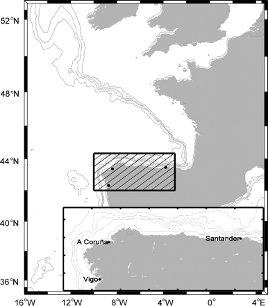
Locations of the tide-gauge stations used.
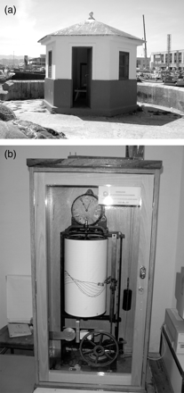
(a) Tide gauge house at Vigo and (b) the float tide gauge.
Hourly sea levels were traditionally calculated by reading historical graphic records either manually or with a digitizing tablet. At present, hourly levels are obtained automatically from digital records (available at 5-min intervals) by extracting the measurements registered at exact times. In the event of high-frequency oscillations, a Butterworth filter is applied to eliminate them while preserving all the energy of the tidal waves (H. Hodnesdal, pers. comm.). The original series recorded at a higher sampling frequency are always preserved for other studies.
The mechanical float-type tide gauges installed in stilling wells are complex measurement systems that can cause mistakes in the record as a result of float friction, well obstructions, clock malfunctioning, cable break, tension losses, etc. (IOC, 1985). Most faulty values were corrected during annual quality controls by inspecting the residuals (defined as observed minus predicted sea-level data), because the residual plot clearly showed both specific mistakes and timing errors (Caldwell and Kilonsky, 1992). The quality control protocols currently applied are specified within the framework of the ESEAS–RI project (García et al., 2005), and they include algorithms to detect and correct faulty values, such as peaks, constant values, or outliers. These algorithms also assign a quality flag to each data. Subsequently, all three series have been homogenized following the standard normal homogeneity test for climatological records (Alexandersson, 1986), relying always on the historical record of the stations and documenting all the changes made in the series. Further, the change of reference detected in A Coruña by Marcos et al. (2005) has been corrected by the EOF method applied to these series and aimed at studying the consistency of the sea-level time-series.
Daily mean sea levels were calculated from the hourly heights with a 119-point convolution filter (Bloomfield, 1976) centred at 12:00. The monthly mean sea levels were obtained by calculating the arithmetic mean of the daily mean sea level for months with more than 17 d of records. A reference mean sea level was obtained for each station from the whole period of data considered.
Relative trends were estimated according to the linear adjustment of monthly mean sea levels. Subsequently, the Post Glacial Rebound (PGR) was corrected as the best approach available for correcting the vertical land displacements at geological time-scales, by applying the results of the geodynamic model ICE-4G proposed by Peltier (2001). Seasonal variations were obtained by averaging each corresponding month, thus avoiding the elimination of river run-off contributions and other non-seasonal local factors.
The spatial variability pattern of the mean sea level and its relationship with climatic indices has been assessed by EOF, a multivariate analysis widely used in climatic studies. EOF analysis reduces the number of variables by creating new orthogonal functions resulting from a linear combination of the initial variables and preserving the largest quantity of possible information from the original dataset (Jolliffe, 1986). In this study, the meteorological contribution was assessed for each station and on a regional scale according to the correlations of the winter NAO index (NAOw) with the normalized time-series from December to March (DJFM) mean sea level for every station and of the NAOw with the EOF mode 1. This analysis was performed once the linear trend was eliminated from the DJFM normalized time-series considered. We used winter data because the correlation was stronger in this study area.
Tidal harmonics were calculated by least-squares adjustment (Foreman, 1977). The decomposition of the tide in its harmonic modes allowed: (i) the prediction of the astronomical tide for any period; (ii) the tidal form factor F, used to classify tides and defined as the ratio of the amplitudes of diurnal (K1+O1) and semi-diurnal (M2+S2) tides (Dietrich et al., 1980); (iii) the age of the tide; and (iv) the time-lapse between the full/new moon passing over the local meridian and the following spring tide. All this information is relevant to navigation and other maritime and coastal activities.
Extreme values were investigated based on hourly sea-level data. Maximum annual values were assumed to fit the Gumbel distribution (Gumbel, 1958), allowing for the calculation of return levels. Annual maximum time-series were formed by the maximum annual value obtained every year. Statistical information and return periods (the time between two equal events) were calculated to estimate the maximum sea-level values taken depending on the historical information available. The fitting of data to a Gumbel distribution permitted the calculation of the probability of obtaining an equal or higher value to that given considering a fixed time interval (Pizarro and Novoa, 1986):
 and
and  , and
, and  and σ are the mean and the standard deviation.
Mean sea level
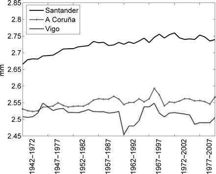
The evolution of the monthly mean sea-level series (1943–2010) showed relative trends of 2.11 mm year−1 at Santander, 2.32 mmyear−1 at A Coruña, and 2.43 mm year−1 at Vigo (Figure 3a). Once corrected for the PGR using the ICE-4G Peltier (2001) model to obtain the absolute sea-level trend, those values became 2.38, 2.45, and 2.65 mm year−1, respectively. Although GPS observations register both the movements attributable to the PGR and those attributable to other geological processes, because of the short period of observation, the GPS trends observed by Wöppelmann et al. (2009) cannot be extrapolated to correct the entire period of sea-level time-series. To date, the decontamination of the PGR has been widely used by the scientific community for its global impact on geological time-scales.
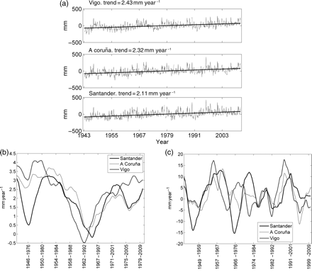
Monthly mean sea level: (a) long-term trend, (b) decadal trend, and (c) 30-year trends.
The trend values found by Marcos et al. (2005) were 2.12, 2.51, and 2.91 mm year−1 from 1943 to 2001 at Santander, A Coruña, and Vigo, respectively, once the PGR had been corrected with the same ICE-4G Peltier (2001) model. The differences could be due to the different dataset period considered, which extends until 2010 in the current study. Moreover, the trend values found in this study for Santander, A Coruña, and Vigo are higher than the global trend of 1.8 mm year−1 estimated by the IPCC (2007) from 1961 to 2003. This difference may be partially the result of local factors, including meteorological ones, but may also result from the spatial variability of oceanic warming and the distribution of water masses.
When considering more recent periods, from 1998 to 2008, the PGR-corrected trends were 3.25, 2.79, and 3.95 mm year−1 at Santander, A Coruña, and Vigo, respectively. This higher trend appears to concur with the ongoing higher trend in recent years shown by altimetry. It is worth mentioning, however, that the calculation period considered for trend estimation greatly influences the results, as is shown for interdecadal trend variability (Figure 3b) or longer periods. In fact, considering decadal periods for the three stations studied, interdecadal trend estimations showed a variability range ∼25 mm year−1, with maxima between 1957 and 1966 and minima from 1951 to 1960 or even from 1998 to 2007. Moreover, as 30 years is the minimum period over which a trend is considered to be stable (Douglas, 1995), we have also calculated the trends for 30-year periods, overlapping year to year. This analysis showed that over these 67 years, the cyclic trend reached a minimal value from 1964 to 1993 (Figure 3c), which is attributed to an increase in the mean atmospheric pressure in winter throughout southern Europe (Tsimplis et al., 2005).
The variation range of monthly mean sea levels over the 67 years was 557 mm in Santander, 697 mm in A Coruña, and 653 mm in Vigo (Table 1). These variations were clearly seasonal. Climograms (Figure 4a) showed that maximum monthly mean values (arithmetical averages for the corresponding months) appeared in October–December, evolving westwards, whereas the minimal values were found in July. Marcos and Simplis (2007) explained this seasonality as the combination of an annual cycle with the warming/cooling of the water column (peaking in summer), and a more variable annual atmospheric cycle related to the predominance of high and low pressures (peaking in winter). Standard deviations were greater in autumn/winter, coinciding with periods of more atmospheric instability. Nevertheless, these seasonal variations did not follow the same pattern over the years studied. Hence, the annual trend of the variation range of monthly mean sea levels was higher from 1987 to 2000 in A Coruña and Vigo. Figure 4b shows annual variation ranges exceeding 400 mm in Vigo in 1989, 1996, and 2000, and minima of 119, 129, and 137 mm in 1944, 2007, and 1973, respectively.
Statistics of the mean sea level (mm) for the period 1943–2010.
| Parameter | Santander | A Coruña | Vigo |
|---|---|---|---|
| Coordinates | 43°28′N 03°48′W | 43°22′N 08°24′W | 42°14′N 08°44′W |
| Sampled period | March 1943–December 2010 | March 1943–December 2010 | May 1943–December 2010 |
| Number of months and time coverage | 791 (97%) | 796 (97%) | 808 (99%) |
| Mean sea level (anomalies) | |||
| Maximum value (month) | 295 (February) | 413 (January) | 434 (January) |
| Minimum value (month) | −282 (March) | −245 (June) | −219 (May) |
| Total range | 557 | 697 | 653 |
| Standard deviation | 88 | 94 | 99 |
| Mode | −105 | −75 | −58 |
| Skewness | 0.30 | 0.39 | 0.59 |
| Kurtosis | 3.46 | 3.69 | 3.58 |
| Linear trend | |||
| Trend (mm year−1) | 2.11 (±0.14) | 2.32 (±0.15) | 2.43 (±0.16) |
| Correction for PGR (mm year−1) | 0.27 | 0.13 | 0.22 |
| Trend corrected for PGR (mm year−1) | 2.38 | 2.45 | 2.65 |
| Climograms | |||
| Maximum value (month) | 69 (November) | 57 (November) | 62 (November) |
| Minimum value (month) | −38 (July) | −47 (July) | −53 (July) |
| Seasonal mean cycle range | 107 | 104 | 115 |
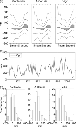
(a) Climograms (grey area), standard deviations (continuous line), and extreme monthly mean sea values (dotted lines). (b) Annual ranges at Vigo. (c) Frequency histograms.
Moreover, throughout the years studied, maximum monthly mean sea levels were observed from October to March (more frequently at the end of the year), and minima from January to August (more frequently in June/July but also in January/February). Table 1 shows the maximum mean sea-level anomalies. In February, 295 mm were recorded in Santander, and in January, 413 mm in A Coruña and 434 mm in Vigo.
Histograms of mean sea-level frequencies showed Gaussian distributions for the three study stations, although each one showed different features of the small variations observed (Figure 4c). At all stations, distribution is slightly deviated towards the right (i.e. more positive than negative residuals), which could be explained by the rising trend in mean sea levels in recent years or by the greater frequency of extreme events that cause the sea level to rise rather than events resulting in a fall in the sea level. This deviation was more accentuated in Vigo and A Coruña (31 monthly values >200 mm and only 6 less than −200 mm in Vigo), whereas the distribution for Santander was more symmetrical, as indicated by the respective skewness coefficient (0.30, 0.39, and 0.59 in Santander, A Coruña, and Vigo, respectively). Regarding the peakedness of the distributions, A Coruña displayed higher peakedness (Kurtosis coefficient k = 3.69) than the others, whose values were 3.46 and 3.58 for Santander and Vigo, respectively.
The results of the EOF analysis applied to the DJFM (winter) monthly mean sea level series showed that mode 1 accumulated 81.86% of the total variance, and modes 2 and 3 explained 11.28 and 6.86% of the total variance, respectively. Pearson's correlation coefficient between mode 1 and the DJFM monthly mean sea-level series was 0.89, 0.93, and 0.89 for Santander, A Coruña, and Vigo, respectively, indicating that mode 1 concurred with the regional sea-level variability pattern on the north coast of Spain. In addition, the correlation between mode 1 and the NAOw index (Figure 5) showed a value of −0.658, similar to the correlation found between the DJFM monthly mean sea levels of each station and the NAOw: −0.602 in Santander, −0.606 in A Coruña, and −0.578 in Vigo. Our results agree with the variability pattern in the mean sea level found by Marcos et al. (2005), although the small differences in the variance values can be attributed to the different period analysed, which in this study also covers the period 2002–2010. Modes 2 and 3 were not significantly correlated with the NAOw, although the correlation between mode 2 and the Santander series was greater and opposite to the correlation between the A Coruña and the Vigo series. This could be explained partially by the fact that atmospheric fronts entering the northwest coast of the Iberian Peninsula are distorted after directly impacting the Galician coast and before reaching Santander (Lavin and García, 1992).
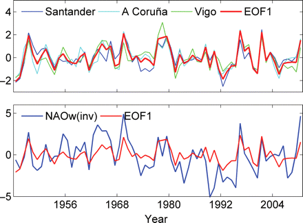
EOF mode 1 and (above) sea-level (DJFM) time-series and (below) inversed NAOw index.
Tides
Table 2 shows the results of the harmonic analysis of the annual series of hourly sea levels. The values of the tidal form factor, F< 0.25 clearly indicate the semi-diurnal character of the tide (Dietrich et al., 1980). The harmonic analysis also allowed the calculation of the lunitidal interval (∼3 h) and tidal age (∼30 h).
Mean values and standard deviations of tidal harmonic constituents, showing the maximum and minimum tidal ranges.
| Constituent | Santander | A Coruña | Vigo |
|---|---|---|---|
| M2 amplitude (m) | 1.31 ± 0.011 | 1.18 ± 0.006 | 1.09 ± 0.005 |
| M2 phase (°) | 94.92 ± 1.29 | 85.98 ± 1.88 | 77.14 ± 0.91 |
| S2 amplitude (m) | 0.45 ± 0.004 | 0.41 ± 0.004 | 0.38 ± 0.004 |
| S2 phase (°) | 127.28 ± 1.80 | 116.058 ± 2.16 | 105.77 ± 1.20 |
| K1 amplitude (m) | 0.064 ± 0.002 | 0.07 ± 0.002 | 0.072 ± 0.001 |
| K1 phase (°) | 70.83 ± 2.10 | 71.05 ± 1.92 | 62.13 ± 1.66 |
| O1 amplitude (m) | 0.07 ± 0.001 | 0.066 ± 0.001 | 0.064 ± 0.001 |
| O1 phase (°) | 323.66 ± 1.44 | 324.37 ± 1.46 | 319.28 ± 1.57 |
| Form factor, F | 0.077 | 0.085 | 0.093 |
| Tidal age | 31 h 51 min | 29 h 36 min | 28 h 10 min |
| Lunitidal interval | 03 h 10 min | 02 h 52 min | 02 h 45 min |
| Astronomical tides | |||
| Maximum range (m) | 4.77 | 4.38 | 4.01 |
| Minimum range (m) | 1.06 | 0.86 | 0.87 |
Once the harmonic constituents were calculated at the three stations, it was possible to know the tidal propagation. The results showed that the lunar constituent M2 propagates northeastwards: from Vigo towards A Coruña and then towards Santander, with <20 min delay from one station to the next. Moreover, M2 amplitude increases northeastwards from Vigo towards A Coruña and Santander. These results are consistent with the numerical models proposed for this North Atlantic region (Schwiderski, 1979). The predicted astronomical tides throughout the complete period of data collection showed maximum tidal ranges of 4.77, 4.38, and 4.01 m in Santander, A Coruña, and Vigo, respectively.
Regarding the changes in M2 wave amplitude and phase in relation to the mean sea-level variations, no conclusive results were obtained. This is probably because the variations in the mean sea level and meteorological factors capable of provoking changes in tidal wave propagation cannot be detected in this area by harmonic analysis sensitivity.
Extreme values and return periods
Maximum and minimum daily hourly values oscillate mainly as a result of tides, and spring and neap tides are a consequence of lunar phases. Frequency histograms corresponding to the maximum and minimum daily hourly values were obtained from the hourly height series. The three tide-gauge stations showed a Gaussian distribution, more symmetrical for the minimal (skewness coefficient 0.00, −0.05, and −0.04 in Santander, A Coruña, and Vigo, respectively) than for the maximum series (skewness coefficient 0.10, 0.12, and 0.14 in Santander, A Coruña, and Vigo, respectively). These differences could be attributed to varying exposure to the influence of more important atmospheric disturbances that cause cyclones and anticyclones. Moreover, the northern Spanish coast is affected by cyclones that are generated locally and by those originating in the Atlantic Ocean and reaching the coast. The Kurtosis coefficients obtained for the maximum series (2.36, 2.37, and 2.44 in Santander, A Coruña, and Vigo, respectively) showed a slightly flatter distribution (Kurtosis < 3) than normal, the Vigo station displaying the higher Kurtosis value and Santander the least, although differences between stations were small.
Table 3 shows the results of the extreme hourly level values analysis. Maximum levels over the respective mean sea level (datum) were 2.55, 2.48, and 2.51 m in Santander, A Coruña, and Vigo, respectively. Higher extreme level values were found when 5-min level values series were computed (instead of hourly data) over a period of 7 years, which showed that when data are available at higher sampling intervals, higher extreme values are more likely to be recorded, so improving the quality of the return period estimations. Extreme sea levels (Figure 6) for return periods of 120 years were estimated at 2.80, 2.63, and 2.61 m, in Santander, A Coruña, and Vigo, respectively, exceeding the recorded maxima over 67 years by 0.25, 0.15, and 0.10 m, respectively. Similarly, the return levels for 50 years exceeded the maximum data recorded over 67 years by 0.16, 0.06, and 0.00 m in Santander, A Coruña, and Vigo, respectively. As the associated error was ∼0.10, these differences were practically negligible, except at Santander (where the associated error was exceeded by 0.06 m), because the series analysed exceeded the 50-year return period. The extreme value of the series is therefore expected to be higher than the 50-year return value. In fact, Flather (2001) suggested that a 50-year data period is adequate to estimate reliably extreme-value statistics. The difference observed at the Santander station could be the result of a poorer fit to the Gumbel distribution function, probably because of location in a large bay. Further studies are required to assess whether the fit should be tried with a different distribution function.
Maxima of sea-level and estimated values for return periods referred to the mean sea level at each location (datum).
| Sea-level values (m) | |||
|---|---|---|---|
| Parameter | Santander | A Coruña | Vigo |
| Maximum observed | 2.55 | 2.48 | 2.51 |
| Return value (50 years) | 2.71 ± 0.10 | 2.54 ± 0.09 | 2.51 ± 0.11 |
| Return value (120 years) | 2.80 ± 0.12 | 2.63 ± 0.11 | 2.61 ± 0.11 |
| Sea-level values (m) | |||
|---|---|---|---|
| Parameter | Santander | A Coruña | Vigo |
| Maximum observed | 2.55 | 2.48 | 2.51 |
| Return value (50 years) | 2.71 ± 0.10 | 2.54 ± 0.09 | 2.51 ± 0.11 |
| Return value (120 years) | 2.80 ± 0.12 | 2.63 ± 0.11 | 2.61 ± 0.11 |
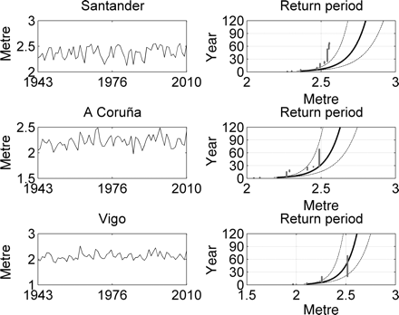
(Left column) Maximum annual sea-level values. (Right column) Estimated (continuous line) and observed (grey dots) return values.
To assess the trend of the extreme levels over 50-year return periods, hourly levels were processed in batches of 30 years, overlapping year to year. The maximum extreme levels estimated were similar for all three stations for a return period of 50 years and when considering the whole dataset. Figure 7 shows the progressive increase in these levels in Santander, closely following the rising trend in the mean sea level. However, A Coruña and Vigo behaved differently: a minimum was found at Vigo over the period 1960–1990, and a maximum was found at Vigo and A Coruña over the period 1967–1997. This probably indicates that whereas at Santander the extreme estimations mainly reflect the mean sea level trend (Marcos et al., 2009), at Vigo and A Coruña, they also reflect the variable trend of shorter periods and extreme events. In fact, the estimated values are strongly controlled by the final few points in the series (Pugh, 2004).
Estimated return levels for 30-year running periods.
Conclusions
In this region, the mean sea level showed the absolute trend values of 2.38, 2.45, and 2.65 mm year−1 in Santander, A Coruña, and Vigo, respectively. These results are slightly higher than the global ocean mean sea level over the past 70 years (1.8 mm year−1), although the higher rising rate of recent years is mainly attributable to interdecadal variability, with some trend values up to 20 mm year−1.
The general spatial variability pattern of the DJFM mean sea level concurs with the regional variability pattern of the north coast of the Iberian Peninsula, represented by the NAOw index. The mode 1 resulting from the EOF analysis explained 81.86% of the total variance and had a correlation value of −0.658 with the NAOw index.
Tides are semi-diurnal in this region, with a maximum range of values of 4.77, 4.38, and 4.01 m in Santander, A Coruña, and Vigo, respectively. The range and phase of the lunar constituent M2 increase towards the northeast.
The extreme estimated values for a 120-year return period overcome the observed maxima by 0.25, 0.15, and 0.10 m in Santander, A Coruña, and Vigo, respectively. A better estimation of the extreme values is found when 5-min level value series are computed instead of hourly data.
Acknowledgements
The authors would like to thanks the reviewers of this paper for their helpful recommendations.
References
Author notes
Handling editor: Bill Turrell
