


Abstract
Regular time-series of temperature and salinity in the upper waters of the northern Rockall Trough can be traced back to 1948, when Ocean Weather Ships on passage to the west began to record them. Since 1975, these data have been complemented by, then replaced by, dedicated Conductivity, Temperature, and Depth sections along 57.5°N. Today, they are enhanced with real-time observations of the upper 1000 m made by an underwater glider. Since 1995, there has been a steady increase in both temperature (from 9.1 to 10°C) and salinity (from 35.32 to 35.41) as the Subpolar Gyre has retreated west. The historical record suggests that such increases could be compatible with decadal scales of natural variability. Nutrient (nitrate, phosphate, and silicate) concentrations have been measured systematically since 1996 and exhibit interannual variability, particularly in nitrate, the causes of which are not immediately clear. Average phosphate concentrations in the upper 800 m declined from 0.80 to 0.63 μM by 2009, consistent with the recent incursion of depleted Subtropical Gyre water. The Ellett Line dataset contains a unique and essential archive of observations that can be used to place in context the recent changes in local ocean climate.Sherwin, T. J., Read, J. F., Holliday, N. P., and Johnson, C. 2012. The impact of changes in North Atlantic Gyre distribution on water mass characteristics in the Rockall Trough. – ICES Journal of Marine Science, 69: 751–757.
Introduction
About half the warm, saline North Atlantic water crossing over the Greenland–Scotland Ridge into the Nordic Seas, as part of the northern limb of the Atlantic thermohaline circulation, passes through the Rockall Trough (Figure 1a). This trough is typically 200 km wide and ∼3000 m deep in the south, shallowing to ∼1000 m at the base of the Wyville Thomson Ridge in the north. The shelves on the eastern and western sides are both of the order of 200 m deep.
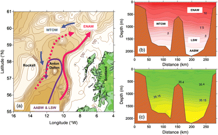
The Rockall Trough: (a) the main water transport pathways; (b) temperature section in October 2006 showing the water masses (ENAW, Eastern North Atlantic Water; WTOW, Wyville Thomson Ridge Overflow Water; LSW, Labrador Sea Water; AABW, Antarctic Bottom Water); (c) salinity section in October 2006.
About 3 Sv (3 × 10⁶ m3 s–1) of the north-flowing Eastern North Atlantic Water (ENAW) in the upper 500–700 m is usually constrained in a narrow band along the edge of the European shelf (Figure 1b and c; Booth and Ellett, 1983; Holliday et al., 2000). A further ∼0.6 Sv of ENAW travels northwards over the deep water. In the northern part of the Trough, the intermediate depths down to 1000 m are occupied by Wyville Thomson Ridge Overflow Water (WTOW), particularly on the western side (Johnson et al., 2010). Beneath 1000 m are recirculating deep waters with origins in the Labrador Sea (LSW) and the Antarctic (AABW).
The hydrography of a section along ∼57.5°N between Scotland and Rockall (the Ellett Line; Figure 2) has been monitored since 1975, with the Scottish Association for Marine Science (SAMS), formerly Dunstaffnage Marine Laboratory and led by David Ellett, initially completing up to four Conductivity, Temperature, and Depth (CTD) sections a year. The line was extended to Iceland by the National Oceanography Centre, Southampton (NOCS), in 1995, but its frequency dropped to typically once per year. Additional sections have been occasionally undertaken by Marine Scotland Science. Regular nutrient observations of nitrate (NO3, which has usually been combined with nitrite, NO2, and is here denoted as NO2+3), phosphate (PO4), and silicate (SiO3) began in 1996.
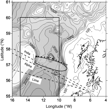
The Rockall Trough, showing the various data sources used here. The dotted line shows the Ellett Line stations from Scotland to Rockall, the rectangle covers the area averaged in HadSST2, and the dashed lines are the tracks of the OWS on passage from the Clyde to their respective Ocean Weather Stations (indicated). The oblate region is the area covered by the glider in 2009/10.
In addition to the Ellett Line, surface temperature and salinity observations across the Trough were measured by Ocean Weather Ships (OWS) on passage to the Iceland Basin and east of Greenland between 1948 and 1994. A further source of historical surface temperatures is the HadSST2 database, which is compiled from many opportunistic observations dating back to 1859, made mainly for the purposes of weather prediction and climate modelling (Figure 2).
The aim of this paper is to summarize the recent trends and variations in the temperature and, in particular, salinity of the upper 800 m of the Rockall Trough over the past 36 years, and to examine the extent to which these observations can be extrapolated back to 1948. Changes in the concentrations of nutrients since 1996 and their possible links to water mass changes are also examined.
Methods
Full-depth Ellett Line section temperature (θ) and salinity (S) data were initially collected with a Bissett Berman STD digital recording profiler which was upgraded to a Bissett Berman 9040 CTD in 1978. Since 1991, pumped SeaBird CTDs have been used. All data have been calibrated to international standards and archived at the British Oceanographic Data Centre (BODC). A critical evaluation of the quality of the data up to 2000 has led to some of the earlier sections being rejected (Holliday, 2002). Section means of these data in the upper 800 m of the water column, and at the density turning point at a depth of ∼1700 m (i.e. in the LSW; Figure 1b), are reported annually in the ICES Report on Ocean Climate (e.g. Hughes et al., 2010). Further information about the Ellett Line can be found at www.noc.soton.ac.uk, and all calibrated data and cruise reports are available from BODC.
Between 1946 and 1994, OWS operated by the UK Meteorological Office out of the Clyde, Scotland, occupied permanent weather stations in the Iceland Basin and off Greenland (Table 1). From 1948 on, these ships made routine observations of surface temperature and salinity across the Rockall Trough. The data collected up to 1992 were comprehensively synthesized, analysed, and tabulated by Ellett and Jones (1994) and are used here to examine the historical θ and S record. Although the sampling methodology developed during this period, the number of weather stations and ships involved gradually reduced, leading to a southward movement in the location of these observations over time (Figure 2, Table 1). From 1975 on, the only remaining track was towards station Lima (57°N 20°W) and ∼1.5° south of the Ellett Line (Figure 2).
Summary of the major relevant events during the period that OWS traversed the Rockall Trough (from Ellett and Jones, 1994).
| 1946 | Start of ocean weather station programme at “Alpha” (east Greenland), “India” (NW of Rockall), and “Lima” (West of Rockall) using four ships |
| 1948 | Collection of underway surface sampling commenced with θOWS and SOWS collected from towed sample bottles and salinity titrated |
| 1956 | Inboard sampling commenced with a mercury-in-glass thermometer (salinity titrations continued) |
| 1961 | Thermistor temperature and thermostat salinometer sampling began |
| 1965 | Autolab salinometer introduced |
| 1975 | Stations “Alpha” and “India” closed and the number of ships reduced to 2 |
| 1982 | Number of ships reduced to 1 |
| 1986 | Guildline autosal salinometer introduced |
| 1994 | Station “Lima” closed, end of record |
The HadSST2 dataset is a historical archive of sea surface temperature measured by ships and buoys back to 1850 that is based on the International Comprehensive Ocean-Atmosphere Data Set (1850–1997) and the US National Centers for Environmental Prediction—Global Telecommunications System (1998 on). The data are averaged by month onto a 5° × 5° grid, and unreasonable biases and trends attributable to changes in instrumentation have been removed. Data are available from the UK Meteorological Office website (www.metoffice.gov.uk). A full explanation of the procedures used is given in Rayner et al. (2006).
In October 2009, SAMS made the first operational deployment of an underwater glider in waters to the west of the British Isles using a Seaglider from Seaglider Fabrication (Eriksen et al., 2001). The glider was released into the shelf waters west of Scotland in October 2009 and patrolled the Rockall Trough just south of the Ellett Line for 5 months, up to March 2010. It reported temperature and salinity at intervals of ∼5 m to a depth of 1000 m roughly every 6 h in real time. The glider used unpumped Seabird Electronics SBE temperature and conductivity sensors, and calibration coefficients determined by the manufacturer before and after the mission were applied to the salinity observations. These data are archived at BODC.
One of the main challenges to defining long-term change in the Rockall Trough is the choice of appropriate metrics, particularly for observations after 2000, when winter cruises ceased and reported observations are likely to have had a warm, saline bias. In their analysis of the OWS data, Ellett and Jones (1994) found that the monthly mean surface temperature ranged through 3.5°C, from <10°C in March to ∼13.5°C in August, and that surface salinity ranged through 0.07 from a minimum of 35.33 in September/October, rising to 35.40 in May. To minimize the seasonal impact, Hughes et al. (2010) use cross-sectional averages of Ellett Line temperature and salinity integrated between the eastern and western boundaries of the Trough and between depths of 30 and 800 m (denoted by θ800 and S800, respectively). As there are relatively few Ellett Line sections, we have used a statistical approach to estimate the equivalent seasonal ranges by binning all observations by month before computing the averages and standard deviations (σθ and σS in Table 2). These annual ranges (defined for our purposes as 2√2σθ and 2√2σS) are estimated to be 0.7°C and 0.06 units, smaller than those at the surface, particularly for temperature. Therefore, although averaging to 800 m involves a small contribution from WTOW in the lower part of the water column, it is clear that θ800 and S800 are better metrics than the equivalent surface ones.
Mean and standard deviation (σ) of temperature and salinity estimates in the Rockall Trough, derived directly from the time-series shown later in Figure 4.
| Parameter | Mean | σθ | Parameter | Mean | σS |
|---|---|---|---|---|---|
| θ800 | 9.28 | 0.25 | S800 | 35.33 | 0.040 |
| θOWS | 9.82 | 0.29 | SOWS | 35.39 | 0.036 |
| θSST | 9.49 | 0.44 |
| Parameter | Mean | σθ | Parameter | Mean | σS |
|---|---|---|---|---|---|
| θ800 | 9.28 | 0.25 | S800 | 35.33 | 0.040 |
| θOWS | 9.82 | 0.29 | SOWS | 35.39 | 0.036 |
| θSST | 9.49 | 0.44 |
For the purpose of objectivity, the θOWS standard deviation includes the dubious 1956–1961 mercury-in-glass temperature observations.
Results and discussion
Variations in temperature and salinity in the upper 800 m since 1975
Between 1975 and 1995, θ800 remained fairly steady, with an average temperature of ∼9.1°C, but it then increased steadily at ∼0.1°C per year to a (summer) peak of close to 10°C in 2006 (Figure 3). Since then the warming appears to have ceased, and temperatures may be getting cooler. At about the same time (from 1995 to 2005), salinity values also increased at ∼0.01 per year (from ∼35.32 to 35.41), but since 2005 they have remained fairly steady. These recent trends are consistent with those in other parts of the eastern North Atlantic and Nordic Seas (Holliday et al., 2008; Hughes et al., 2010) and have been linked to the westward retreat of the Subpolar Gyre and Subpolar Front in the mid-Atlantic (Hakkinen and Rhines, 2004; Hátún et al., 2005).
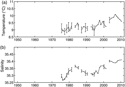
Annual mean values of (a) θ800 and (b) S800 since 1975. The error bars show the standard deviation for the years when there was more than one cruise; there are no error bars for later years when there was just one cruise.
However, the Ellett Line time-series are relatively short and leave one with the intriguing question of whether the recent peaks are unprecedented in modern times, and hence attributable to anthropogenic warming of the climate, or whether they are simply part of a natural cycle. To answer this question, we need to investigate other, possibly less robust, time-series.
The OWS surface temperature and salinity
Following Ellett et al. (1986), we use OWS surface measurements of temperature and salinity (θOWS and SOWS) averaged over the winter months of January, February, and March (JFM) when the upper the winter months column is closest to being well mixed, and surface values are likely to be near the underlying θ800 and S800. These two measures are not identical because (as the monthly averaged glider data—not shown—indicate) winter convection progressively mixes the water column through to March and because the OWS sections lie south of the Ellett Line. Sampling methods will also lead to differences.
Although the θOWS had a mean value of 9.82°C (Table 2), for most of the time, it fluctuated around 9.75°C (Figure 4). The exception to this, the period 1956–1961 when θOWS rose rather abruptly to 10.3°C, coincided with the use of inboard mercury-in-glass thermometers, which renders these values suspect. The mean SOWS was 35.39. To examine the impact of surface vs. deep-water sampling, observations of θ800 and S800 from winter Ellett Line cruises have been averaged over JFM along with similar depth averages over the top 4 m (θ4 and S4) to represent equivalent surface sampling (Figure 4). They indicate that although between 1975 and 1986 there was very good agreement between S4 and SOWS, at other times θOWS was up to 0.5°C warmer than θ4.
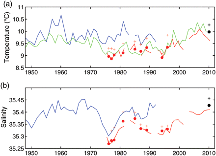
Historical time-series of (a) temperature and (b) salinity in the Rockall Trough since 1948. Red lines, θ800 and S800; blue lines, θOWS and SOWS for winter (JFM); green line, θSST for JFM. Dots and plus signs indicate the JFM values of θ800 and S800 and θ4 and S4, respectively, from Ellett Line cruises (red) and from the glider (black). See text for definitions of the variables.
The early part of this period coincided with the end of OWS “India” and “Alpha”, and the subsequent observations by OWS “Lima” were ∼1° of latitude farther south. The climatological winter meridional surface temperature and salinity gradients at 57°N are ∼0.25°C and 0.015 per degree of latitude, respectively (www.esrl.noaa.gov/psd/), which would imply a relative increase in θOWS and SOWS of only 0.25°C and 0.015 units at most. Therefore, perhaps even after the replacement of the mercury-in-glass thermometer by a thermistor in 1961, the θOWS water was warmed along the intake pipe. Paradoxically from 1986, when a Guildline Autosal Salinometer was introduced, the difference between θOWS and θ4 decreased, but SOWS became up to 1 unit more saline than S4 (much more than can be explained by simple climatology). However, it is not clear from the temperature salinity plots (not shown) whether these anomalous readings were due to the changes in technology or to unusual environmental conditions.
The HadSST2 record
Monthly HadSST2 data are provided averaged over a rectangle bounded by 10° and 15°W and by 55° and 60°N (Figure 2). This region includes a large part of the Rockall Trough, but as it is centred on 57°N, there should be little meridional bias. However, it also covers the Rockall Bank, which can be relatively cool in winter (Ellett, 1968), and omits the warm shelf-edge current water (Figure 1b) so it is likely that winter sea surface temperatures (SSTs) are a little cooler than those found from averaging across the Rockall Trough. The JFM averages of HadSST2 SST observations (θSST) were nevertheless very similar to θ800 from 1975 on and to θOWS from 1962 to 1973 and 1985 to 1992. At other times (i.e. the period between 1956 and 1961 and the period around 1980), θOWS values were significantly warmer than θSST. The earlier of these anomalously warm periods coincides with the time when the OWS started using inboard mercury-in-glass thermometers, which reinforces the belief that there is a problem with those measurements.
A synthesis of the temperature and salinity time-series
The variation in the mean temperatures reported by the three methods of observation is large (nearly 0.5°C; Table 2), but this can be attributed as much to the different methods of measurement and location as to environmental factors. However, their individual variability, as measured by σθand σS, is fairly similar. This similarity of magnitude may indicate that there has been little discernible change in the natural decadal variability of the temperature regime over the past 60 years. The difference in the mean values of S800 and SOWS appears to be mainly attributable to the different parts of the water column sampled, but the similarity in their σS values also suggests that there has been little change in the magnitude of natural salinity variability over that time.
No attempt has been made to construct a synthetic time-series of the historical θ800 in the central Rockall Trough given the uncertainties in some of the early θOWS observations. However, the reasonably good match between θSST and θ800 from 1975 on implies that θSST is a good proxy for θ800 for winter conditions back to 1948. That being the case, it would appear that there are effectively three temperature regimes in the record: (i) a warm regime before 1974 when the mean θSST was ∼9.7°C; (ii) a cooler regime of ∼9.2°C that started in 1974 with the arrival of the Great Salinity Anomaly from the Labrador Sea (Ellett, 1980; Dickson et al., 1988) and continued to 1995, after which (iii) there has been a progressive rise in θSST to a maximum of >10°C in the past 5 years as the Subpolar Gyre retreated. Whether this rise has now reversed is uncertain. Recent shipborne θ800 observations suggest that it has, but observations of θ800 and θ4 by the glider during JFM of 2010 suggest that it has merely levelled off (Figure 4).
In contrast, the good fit between S4 and SOWS during the period 1975–1985 gives some reason to believe (if the anomalously high values of SOWS between 1985 and 1995 are accepted) that SOWS may be a reasonable proxy for S800 before 1975. The most striking feature in the record remains the Great Salinity Anomaly, which was a 10-year event in the Rockall Trough that resulted in minimum salinities (S800 = 35.27, SOWS = 35.30) in 1976. In contrast to θ800, which remained low for the next 20 years, S800 appears to have recovered its original values within 5 years of the minimum. Other smaller anomalies appear at the beginning of the record, in 1950 (SOWS = 35.34), and again in 1995 (S800 = 35.30). Since then, S800 has increased to ∼35.41 in recent years as ENAW has gradually penetrated the Rockall Trough from the south, with the retreat of the Subpolar Gyre.
Observations of nutrient concentrations in the Rockall Trough
Autoanalysers have been used in the analysis of full-depth nutrient sampling that started in 1996, and information about calibration techniques and results can be found in the relevant cruise reports on the BODC database. No detailed independent assessment has been made of data quality, nor have laboratory intercomparison studies been conducted, so the size of any intercruise measurement errors is unknown.
As nutrients have non-conservative properties, they are not expected to be as robust water mass tracers as temperature and salinity. In addition to surface seasonal variations, which are also linked to the variations in temperature and salinity and are ignored for our purposes, long-term water column variability may depend on biological activity. Therefore, we do not expect that all the spatial patterns or trends and temporal regimes seen in the physical variables will be reflected in the nutrient observations. Despite these caveats, there are enough independent sections to allow some long-term changes to be discerned.
Nutrient samples have been collected at typically 5–15 discrete levels in the water column, with a greater density of samples near the surface so, unlike the temperature and salinity observations, they are not continuous with depth. Synthetic nutrient profiles were derived by interpolating each cast onto 25-m intervals from 10 to 2330 m. Cross-sectional averages were created from these interpolated data. With an average of just one cruise per year, it is not possible to allow for seasonal variations in the surface waters. Nevertheless, as the dashed lines in Figure 5 show, the overall scatter is sufficiently small to generate confidence in the discussion of the broad features that follows.
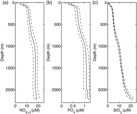
Mean profiles of (a) nitrate (plus nitrite), (b) phosphate, and (c) silicate concentrations between 1996 and 2009 (plain lines), and the spread of the observations at ±1 s.d. about the mean (dashed lines).
Average near-surface nitrate and phosphate levels are generally depleted (Figure 5a and b), but below 100 m and down to 800 m, there is a slow rise in concentrations to ∼14.7 and ∼0.9 μM, respectively. Through the next 200 m, i.e. in the deep pycnocline, concentrations increase rapidly in both nutrients to values of ∼16.8 and ∼1.03 μM, respectively, but below 1000 m, they increase very slowly with depth.
Although silicate concentrations also exhibit an increase in concentration with depth (Figure 5c), their profile tends towards a more uniform increase in concentrations from ∼5 μM near the surface to ∼14 μM at 1700 m. At deeper levels, they increase rapidly to >22 μM at 2200 m (on the deeper eastern side of the Anton Dohrn seamount). Such high silicate levels confirm that bottom waters contain AABW, which has the highest silicate content in the ocean (Levitus et al., 1993).
The depth mean concentrations (between 30 and 800 m) of SiO3 have remained fairly steady over the past 15 years at 4.8 ± 0.2 μM (Figure 6). In contrast, there is a fairly high interannual variability of the concentrations of NO2+3 (11.8 ± 1.4 μM) and PO4 (0.71 ± 0.08 μM). An explanation for this variability (and whether it has a natural or experimental basis) is beyond our scope, although Ellett and Martin (1973) found that the seasonal variation of silicate and phosphate profiles between 100 and 700 m ranged through ∼1 and 0.1 μM, respectively. Summer concentrations were higher than in winter because the nutrient-depleted surface waters mix downwards in autumn. It is not possible to tell whether there has been any significant change in mean NO2+3 levels since 1996 (only the interannual variability has increased).
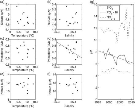
Mean concentrations in nutrients between 30 and 800 m for the period 1996–2009. (a) SiO3 vs. θ800; (b) SiO3 vs. S800; (c) PO4 vs. θ800; (d) PO4 vs. S800; (e) NO2+3 vs. θ800; (f) NO2+3 vs. S800; (g) time-series of all three nutrients. The linear regression line in (d) omits the 1999 data (dot) and has regression coefficient r2 = 0.50. The linear regression line in (g) has a PO4 decline of 0.013 μM per year and r2 = 0.44.
From linear regression, however, the mean PO4 concentrations have decreased at an average rate of 0.013 μM per year, from 0.80 μM in 1996 to 0.63 μM in 2009. Ignoring 1999, when the maximum PO4 value of 0.86 μM was observed, there is also a significant negative correlation (r2 = 0.5) between salinity and PO4 (Figure 6d). Therefore, this decrease can be linked to the retreat of the Subpolar Gyre and the incursion into the upper layers of the Rockall Trough of ENAW from the Subtropical Gyre, which is relatively depleted in phosphate (Levitus et al., 1993).
Conclusions
The upper waters of the Rockall Trough have undergone a series of significant interdecadal changes over the past 60 years which are summarized below.
A relatively warm period existed between 1948 and 1972, with winter surface temperatures of ∼9.6°C.
Subsequently, there was a cooler period (9.2°C, θSST) until about 1995.
The start of this cooler period (1972) coincided with the advent of the Great Salinity Anomaly, which itself lasted to about 1982 (minimum S800 = 35.27).
There was a second, less intense freshening in the early 1990s (minimum S800 = 35.30).
A steady increase in θ800 and S800 (to 10°C and 35.41) has persisted from 1995 to almost the present day. This phenomenon, which is reflected throughout the northern North Atlantic, is linked to a changing balance in Subpolar and Subtropical Gyre waters.
Finally, there has been a steady decline in phosphate concentrations since 1996 (from 0.8 to 0.6 μM) that seems to be linked to the increase in Subtropical Gyre water.
Most of these changes are linked to the movement and exchange of water masses in the northern North Atlantic, and it is not possible to say whether the upward trends in heat and salinity of the 1990s and the 2000s in the Rockall Trough will restart following their recent slowdown and partial reversal. Further, it is uncertain whether the changes of the past 15 years lie outside the range of natural variability for the past 60 years or whether they can be attributed to anthropogenic warming. Set against this, though, Ellett and Martin (1973) noted that in the Rockall Trough, the mean winter surface temperatures to depths of 400 m or more between 1948 and 1965 were ∼1°C greater than those observed between 1876 and 1915 (reported in Smed, 1949). Notwithstanding the fact that we can have less confidence in the accuracy of the early observations, this increase is much greater than any temperature changes reported here.
Given this uncertainty, and the concerns about anthropogenic climate change, a very strong case can be made for continuing the Ellett Line, which is an essential sustained monitoring programme in the Rockall Trough. Looking into the future, we expect that there will be increasing use of gliders, which are much cheaper than research vessels and can patrol throughout winter. Although at present they are restricted to the top 1000 m and are unable to measure nutrients, technological developments are in hand that should overcome these limitations.
Acknowledgements
It is impossible to identify and acknowledge all the individuals and institutions that have contributed to the data described here. Ellett Line cruises conducted by SAMS and NOCS have been funded by UK Natural Environment Research Council (NERC) since 1975. The present-day cruises, the glider mission, and this paper are supported by Sustained Observation programme No. 4 of NERC's Oceans2025 strategic marine science programme. The cruises by Marine Science Scotland are supported by the Scottish Government. The climatological surface temperature and salinity gradients were derived from images provided by the Physical Sciences Division, Earth System Research Laboratory, National Oceanic and Atmospheric Administration, Boulder, CO, from their website at www.esrl.noaa.gov/psd/.
References
Author notes
Handling editor: Bill Turrell
