


Abstract
European and national policy commitments require further integration of fisheries and environmental management. We measured fishery footprints and assessed trade-offs between landings value, habitat sensitivity, and beam trawling impacts in UK territorial waters in the southern and central North Sea where marine spatial planning is underway and a network of Marine Protected Areas has been proposed. For fleets (UK and non-UK) and years (2006–2010) considered, total trawled area included extensive ‘margins’ that always accounted for a smaller proportion of total fishing effort and value (proportions investigated were ≤10, 20, or 30%) than their proportional contribution to total habitat sensitivity and trawling impact. Interannual and fleet-related differences in the distribution and intensity of trawling activity, driven by location choice and fisheries regulations, had more influence on overall trawling impacts than the exclusion of beam trawlers from a proposed network of Marine Protected Areas. If reducing habitat impacts is adopted as an objective of fisheries or environmental management, then the direct management of fishing footprints, e.g. by defining fishing grounds that exclude existing margins, can disproportionately reduce trawling impacts per unit effort or value.Jennings, S., Lee, J., and Hiddink, J. G. 2012. Assessing fishery footprints and the trade-offs between landings value, habitat sensitivity, and fishing impacts to inform marine spatial planning and an ecosystem approach. – ICES Journal of Marine Science, 69: 1053–1063.
Introduction
Political processes leading to the designation of Marine Protected Areas (MPAs) and the adoption of spatial plans have been characterized by debates on the acceptability of fishing impacts and the allocation of space to fishers and other users of the sea (Gray et al., 2005; Pedersen et al., 2009a). This is unsurprising when management objectives for fisheries may not reflect the preferences of conservationists and when fishing typically uses and impacts greater areas of the seabed than other sectors (Rice, 2005; Eastwood et al., 2007). The evidence base to inform these debates would be improved by information on the footprints and impacts of fisheries in space and time and on the contributions of fishing activities in different parts of the overall fishing grounds to total catch value and environmental impact.
It is remarkable that so little information on the anatomy of fishing grounds and the environmental performance of fisheries is usually available when discussing fisheries and environmental management measures and spatial plans. The main exceptions have been when maps of fishing activity and impact assessments were provided to advise on interactions between fisheries and habitats in proposed MPAs (e.g. ICES, 2005, 2007; Fock 2008; Pedersen et al., 2009a, b), but these have focused on fishing inside the proposed MPAs rather than assessing the proposed MPAs in the context of the overall fishing grounds.
Vessel monitoring systems (VMSs) provide position and speed data for individual fishing vessels (reviewed in Lee et al., 2010). Position data can be linked with logbook catch and price data to map catch and catch value distributions (e.g. Gerritsen and Lordan, 2011). VMS data have been collected since 2000 in European waters and thus provide records of temporal changes in fishing activity. VMS data also support high resolution analyses of interactions between fishing vessels and seabed habitats (e.g. Dinmore et al., 2003).
Vessels fishing with mobile towed gears impact seabed habitats. The magnitude of impact depends on the sensitivity of the seabed and the intensity of fishing pressure (Collie et al., 2000; Kaiser et al., 2006). Sensitivity can be expressed as recovery time, following a stress of defined magnitude and duration (e.g. Bax and Williams, 2001). Since there is spatial variation in habitat sensitivity, changing distributions of fishing pressure lead to changing impacts. In addition, because the first pass of a given fishing gear over the seabed has a greater impact than subsequent passes (Kaiser et al., 2002), impacts per unit fishing pressure on a given habitat type will be greater in less intensively fished areas.
If fishing impacts on the seabed are expressed in relation to effort or catch value, they provide a metric of one aspect of the environmental performance of fisheries. At present, performance metrics of this type do not contribute to fishery management advice, but they could provide useful guidance if objectives for acceptable levels of impact were established. Holland and Schnier (2006) suggested, for example, that fishers might be charged differentially for access to fishing grounds, depending on habitat sensitivity, possibly by providing individual habitat quotas that set a cap on total impact but leave the fishers to choose whether the quota is used to fish more frequently on low sensitivity habitats or less frequently on high sensitivity habitats.
In the seas around the UK, as in many other countries, MPAs are being selected and designated to meet political commitments. These commitments focus as much on the designation of the MPAs (e.g. by setting objectives for the area designated or representation) as on the changes to the environment they might achieve (e.g. by setting objectives for the overall state of the environment where MPAs contribute as one of a number of management measures). In practice, the criteria and processes used to identify and designate MPAs may not be based solely on scientific evidence; therefore, it is informative to compare the potential effects of proposed MPAs on the overall state of the environment with the effects that might be achieved using other management measures.
Here, we describe the fishing activities of UK- and non- UK-registered beam trawl vessels in an area of the southern and central North Sea that is the focus of a pilot spatial planning process and where MPAs have been proposed. Our motivation is to quantify how the use of fishing grounds affects habitat interactions and seabed impact, taking advantage of a growing time-series of VMS data for vessels in the study area that primarily target plaice and sole (e.g. Hutton et al., 2004; Gillis et al., 2008). Activities of these vessels are affected by a multiannual management plan for plaice and sole (EC, 2007). Two objectives of the plan are to ensure ‘that stocks of plaice and sole in the North Sea are brought within safe biological limits’ and to ensure that they are ‘exploited on the basis of maximum sustainable yield and under sustainable economic, environmental and social conditions’. To achieve those objectives, the plan states that the European Commission (EC) ‘is to apply the precautionary approach in taking measures to protect and conserve the stock, to provide for its sustainable exploitation and to reduce to a minimum the impact of fishing on marine ecosystems’. Processes to assess impacts on the marine ecosystem and then to minimize them have yet to be defined. The plan also notes that total allowable catches (TACs) for these fisheries ‘should be complemented by a system of fishing effort limitation’ that is in line with the TAC but capped at the 2006 level. Thus, although effort cannot increase, the fishery footprint and impact can still vary in space and time.
Methods
Beam trawlers were suitable for the analysis of benthic impact owing to the fixed geometry of beam trawl gear, which makes it possible to approximate the rate of seabed impact per unit time from information on vessel speed and position (e.g. Dinmore et al., 2003). Beam trawlers are expected to be responsible for most of the seabed impact of towed gear fisheries in the study area, accounting for 22–48% of total fishing hours (yielding 23–51% of annual landings) by UK vessels and 59 81 % of fishing hours (yielding 40–84% of annual landings) by non-UK vessels from 2006 to 2010 [Marine Management Organisation (MMO), unpublished, noting that non-UK data are incomplete because records of gears are not available for all vessels tracked with a VMS]. Seabed impacts were described as changes in benthic biomass or production in response to trawling frequency, as estimated with a validated size-based model (Hiddink et al., 2006a).
Fishing effort and value
Assessment of the distribution and intensity of trawling activity by UK and non-UK vessels was based on an analysis of VMS vessel identity, position, and speed data obtained from the Marine and Fisheries Agency (MFA; now the MMO) of the UK Department of Environment, Food and Rural Affairs (Defra). VMS records for the relevant vessels in the years 2006–2010 were included. Unprocessed VMS data do not indicate whether vessels are in port, fishing, steaming, or underway but not making way. Therefore, records linked to fishing activity were identified following Lee et al. (2010). In brief, duplicate VMS records and records close to ports were removed, the time interval between remaining records was calculated, and a speed-based rule was applied to identify periods of fishing activity. Vessels travelling at speeds of 2–8 knots were assumed to be fishing, based on an analysis of the frequency distribution of speeds for vessels that were known to be trawling (Mills et al., 2007). Each period of fishing activity (in hours) was assigned to a vessel and gear type by linking the VMS data to national logbook data using the vessel identifier and time. ‘Fishing’ records were assigned to a 3 ×3 km grid. Trawling frequency was expressed as the number of times each grid cell was swept each year following Dinmore et al. (2003). In this calculation, beam trawlers were assumed to tow two beam trawls, each 12 m wide (Mills et al., 2007). The study area comprised 8469 cells or 76 221 km2. For non-UK vessels, the available information on vessel and gear type could not be linked to logbook landings data.
Landings and value of landings from each grid cell were estimated by reallocating landings weight and landings value data from the scale of collection and reporting (ICES rectangles) by vessel and by trip to the scale of the grid cell, in direct proportion to estimated trawling activity. Landings weight and landings value data by trip for individual UK vessels were obtained from the MFA and MMO. The approach assumed that trawling activity and landings are directly related at any scale smaller than one ICES rectangle. This is an approximation, but deviations from the approximation cannot be assessed as landings and landings value data are not collected at subrectangle scales.
To define boundaries for trawled areas that included a stated proportion of total fishing effort or value, cumulative effort or value was calculated by summing effort or value by grid cell in rank order from high effort or value to low effort or value. The total area trawled, here defined as the total footprint of fishing, at a given grid cell resolution (here 3 ×3 km) and accounting for 100% of total effort (E) or value (V), was denoted AE100 or AV100. Smaller areas, that only included grid cells accounting for the upper x% of yield or value, were denoted AEx and AVx respectively
Sensitivity
The time (d) that the biomass (B) or production (P) of the benthic community took to recover to 90% of unimpacted biomass (B0.9) or production (P0.9), following a single pass of a beam trawl, was used as a metric of habitat sensitivity. Recovery times were estimated with a size-based model that had been validated with benthic community data collected at sites in the study area (Hiddink et al., 2006a). Model structure, parameterization, validation, and sensitivity to parameter values are described in Duplisea et al. (2002) and Hiddink et al. (2006a). Briefly, the interaction between habitat type and trawling impacts, that determines variation in sensitivity, was modelled by including relationships between benthos growth, mortality, and the environment in the model. Thus, sediment type affected trawling mortality, sediment erosion rates affected natural mortality, the effect of bed shear stress modified population growth rate, and the chlorophyll a content of the sediment affected carrying capacity. Predicted B and P with no trawling were determined by running the model for 1500 time steps of 30 d without trawling in each grid cell. Then, after trawling once, the time taken for the benthic community to ‘recover’ was determined. Total sensitivities for B or P in a given area were calculated as the sum of recovery times to B0.9 or P0.9, expressed in years, for all of the grid cells comprising that area.
Impact
Impacts of trawling on benthic communities were estimated with the same size-based model that was used to predict recovery times (Hiddink et al., 2006a). We predicted absolute changes in B and P (expressed as ash free dry mass, AFDM) that result from a given distribution and intensity of trawling. B and P were estimated for each cell in the 3 × 3 km grid. The distribution of trawling effort inside cells was assumed to be random for the purposes of calculation. Rijnsdorp et al. (1998) have already demonstrated that the distribution of Dutch beam trawl effort in the southern and central North Sea is typically random (>90% of cells) at scales of 1.85 ×1.85 km and usually random at scales of 5.56 ×5.56 km, with some exceptions south of 53.5°N. B or P were expressed at equilibrium, assuming that any given intensity and distribution of trawling was maintained.
Cumulative sensitivity or impact was calculated by summing grid cell sensitivity or impact in the rank order used to calculate cumulative effort or value. A higher value of cumulative sensitivity for a given fishing effort indicates that more sensitive habitats are fished, while a higher value for cumulative impact indicates that more biomass or production is lost as a result of beam trawling disturbance. Sensitivity per unit area (SPUA) and sensitivity per unit value (SPUV) were calculated as total sensitivity divided by total area and total value, respectively, for any defined group of vessels and time period.
Sensitivity and impact were reported for areas that will be considered as ‘marine conservation zones' (also known as MPAs) as part of a UK process in support of commitments made in the UK Marine Act (Ashworth et al., 2010; Net Gain, 2011). We did not include areas already being considered as Special Areas of Conservation (e.g. JNCC, 2010).
Results
There were spatial differences in the fishing grounds used by UK- and non- UK-registered beam trawlers from 2006 to 2010. The most intensively trawled areas that accounted for 70% of annual UK effort (AE70) were in the east of the study area, while the corresponding areas for non-UK vessels were in the south (Figure 1), where the sensitivities of biomass and production to trawling disturbance were generally lower (Figure 2).
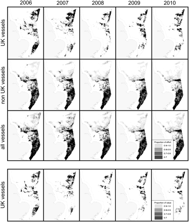
Distribution of beam trawling effort for UK, non-UK, and all vessels >15 m in length in the south and central North Sea from 2006 to 2010. Fished cells accounting for the top 70% of total effort (upper panel, effort ranked by cell from high to low) or value (lower panel, value ranked by cell from high to low; value for UK vessels only), and 70–80, 80–90, and 90–100% of total effort or value are shown. The fine grey lines indicate the boundary of the study area.
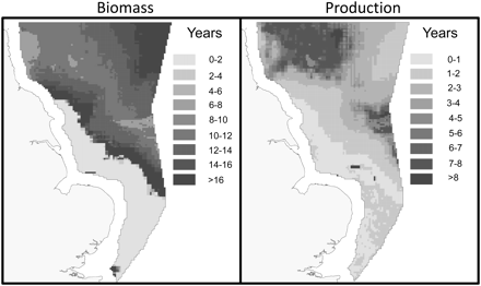
Spatial variation in predicted recovery times (years) of benthic community biomass and production following trawling disturbance in the south and central North Sea.
The total footprint of fishing (AE100) for all vessels (UK and non-UK combined) varied from 33.0 to 38.5 × 10³ km2 among years, equivalent to 43.3–50.6% of the 76.2 × 10³ km2 study area (Table 1). However, AE100 included core areas that accounted for the majority of effort and relatively extensive margins that accounted for much less. Thus AE90, the area encompassing 90% of AE100, was 49–54% of the fished area, AE80 was 35–40% and AE70 was 26–31%. On average, 70% of fishing effort by all vessels was confined to 28.2% of AE100. Concentration of effort in core areas was reflected in the relatively higher effort per unit area and value of catches per unit area in core areas (Figure 3).
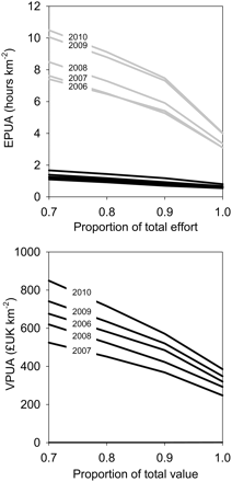
Changes in trawling effort per unit area (EPUA, upper panel) by year for UK (black lines) and non-UK (grey lines) vessels and in catch value per unit area (VPUA, lower panel) for UK vessels, as a function of the proportion of total effort or value included in the calculation. Effort or value are expressed as a proportion of total effort or value, and cells with the highest rank effort are included first. Each line in each a panel represents a different year in the period 2006–2010.
The size (km2, in parentheses) of total areas fished by UK and non-UK beam trawlers from 2006–2010 and the proportions of those areas that account for 70, 80, or 90% of total effort or catch value if cells with the highest rank effort are included first.
| Percentage | 2006 | 2007 | 2008 | 2009 | 2010 | |
|---|---|---|---|---|---|---|
| UK effort | 70 | 0.34 | 0.34 | 0.35 | 0.37 | 0.36 |
| 80 | 0.45 | 0.46 | 0.48 | 0.49 | 0.49 | |
| 90 | 0.61 | 0.66 | 0.71 | 0.67 | 0.68 | |
| 100 | (24 327) | (19 143) | (9738) | (13 221) | (13 185) | |
| UK value | 70 | 0.33 | 0.33 | 0.33 | 0.33 | 0.32 |
| 80 | 0.44 | 0.44 | 0.45 | 0.44 | 0.43 | |
| 90 | 0.59 | 0.61 | 0.62 | 0.60 | 0.61 | |
| 100 | (18 486) | (14 256) | (7398) | (11 412) | (11 394) | |
| Non-UK effort | 70 | 0.29 | 0.29 | 0.28 | 0.28 | 0.27 |
| 80 | 0.38 | 0.38 | 0.37 | 0.36 | 0.35 | |
| 90 | 0.51 | 0.53 | 0.51 | 0.49 | 0.48 | |
| 100 | (38 430) | (38 538) | (36 036) | (32 985) | (34 155) | |
| All effort | 70 | 0.31 | 0.29 | 0.27 | 0.28 | 0.26 |
| 80 | 0.40 | 0.39 | 0.36 | 0.36 | 0.35 | |
| 90 | 0.54 | 0.55 | 0.51 | 0.50 | 0.49 | |
| 100 | (43 506) | (44 163) | (39 429) | (35 892) | (37 755) |
When UK- and non- UK-registered vessels were considered separately, the difference between the minimum and maximum AE100 among years was 14.5 × 10³ km2 for UK vessels and 5.6 × 10³ km2 for non-UK vessels (Figure 4a). Interannual variation in the spatial extent of core fishing grounds, here defined as the difference between the minimum and maximum AE90, was smaller; 8.0 × 10³ km2 for UK and 4.3 × 10³ km2 for non-UK vessels. AE90 did not exceed 71% of AE100 for UK vessels and 53% of AE100 for non-UK vessels in any year (Table 1). On average, AE90 was 66.6% of AE100 for UK vessels and 50.4% for non-UK vessels (Figure 1, Table 1). For UK vessels, AV90 was 60.6% of AV100 (Table 1). There were differences in the estimated areas of fishing grounds based on effort and value for UK vessels (Table 1) because landings data were not available for some trips recorded on VMSs.
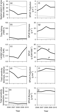
Trends in (a) distribution of effort, (b) effort, (c) catch value, (d and e) habitat sensitivity on the fishing grounds (rescaled to maximum sensitivity), (f and g) sensitivity of habitat trawled per unit fishing effort (SPUE), (h) sensitivity of habitat trawled per unit catch value (SPUV), and (i and j) sensitivity of habitat trawled per unit area trawled (SPUA) by UK (black line) and non-UK (grey line) beam trawlers from 2006 to 2010. ‘B’ and ‘P’ in (h) indicate biomass and production, respectively.
Recognizing interannual variation in the extent and location of fishing grounds (Figure 1, Table 1), we assessed the proportion of total annual effort from 2007 to 2010 that would be included in AE100 or AE90 as defined with 2006 data. For AE100, the ranges were 82–85% for UK vessels, 97–100% for non-UK vessels, and 98–100% for all vessels. For AE90, the ranges were 61–71% for UK vessels, 84–91% for non-UK vessels, and 83–92% for all vessels.
Total fishing effort in the study area ranged from 5 to 20× 103 h year−1 for UK vessels and from 118 to 137 × 103 h year−1 for non-UK vessels. Effort by UK vessels decreased from 2006 to 2010, but non-UK effort increased (Figure 4b). There were large within-year variations in effort for non-UK vessels but smaller variations for UK vessels (Supplementary material, Figure S1). A landed value could only be assigned to UK vessels, and it decreased and then increased between 2006 and 2010 (Figure 4c). Based on the recorded distribution of fishing effort and the modelled sensitivity of habitat, the total sensitivity in AE100 decreased with time (Figure 4d and e).
When grid cells were ranked from low to high sensitivity, the rate of increase in cumulative sensitivity broadly followed the rate of increase in effort for UK vessels but not for non-UK vessels (Figure 5). However, within each group of vessels, differences between cumulative fishing effort and cumulative habitat sensitivity were maintained with time. For non-UK vessels, in all years, >60% of effort was in areas of the fishing ground that accounted for <25% of biomass and production sensitivity (Figure 5c). When all vessels were considered together, the bulk of effort was still confined to the less sensitive areas in all years (Figure 5), owing to the large contribution of non-UK effort to total effort (Figure 4b). For the grounds fished by UK vessels, there was little difference in habitat sensitivity in core and marginal areas (Supplementary material, Figure S2). For grounds fished by non-UK vessels, habitats in the marginal areas of the grounds tended to be more sensitive (Supplementary material, Figure S2).
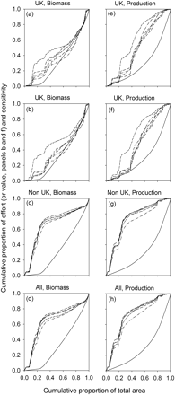
Cumulative relationships between the sensitivity of benthic biomass (a–d) and production (e–h) impacted by trawling, the allocation of trawling effort (or catch value) to habitats, and the area trawled by UK, non-UK, and all vessels. Solid lines show relationships for habitat sensitivity, and broken lines show the relationships for beam trawling effort (a, c, d, e, g and h) or value (b and f). Each broken line in each panel represents a different year.
Sensitivity per unit effort (SPUE) is a measure of the sensitivity of the habitats that beam trawlers impact per unit time. SPUE was relatively stable among years (Figure 4f and g) but varied among seasons (Supplementary material, Figure S1). Seasonal variations were most marked for UK vessels that moved between low sensitivity grounds in the extreme south and more sensitive grounds to the north. SPUA is a measure of the sensitivity of the habitat impacted per unit fished area, where the fished area is the total footprint of fishing (AE100). SPUA was stable among years (Figure 4i and j) but varied among seasons (Supplementary material, Figure S1). SPUV is a measure of the sensitivity of habitat impacted per unit value of landings. SPUV for UK vessels decreased with time, predominantly driven by increases in fish prices rather than changes in the area fished (Figure 4h).
Relationships between trawling effort and impact revealed that a small proportion of total effort outside the core fishing ground (AE90) accounted for a relatively large proportion of seabed impact (Figure 6; Supplementary material, Table S1). Predicted Bloss owing to trawling ranged from 48–107 × 103 t AFDM for UK vessels to 139–185 × 103 t for non-UK vessels (Supplementary material, Table S1). For all vessels combined, Bloss was 171–239 × 103 t AFDM. Corresponding figures for Ploss were 12–31 × 103 t year−1 for UK vessels, 75–91 × 103 t year−1 for non-UK vessels, and 84–112 × 103 t year−1 for all vessels. Estimated B and P in the study area in the absence of fishing were 708 × 103 t and 777 × 103 t year−1 respectively.
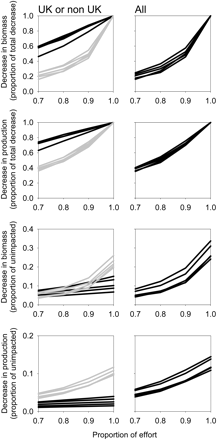
Estimated changes in benthic biomass or production as a function of the proportion of total trawling effort included in the calculation. Effort or value are expressed as a proportion of total effort or value, and cells with the highest rank effort are included first. Changes are expressed as a proportion of the total decrease in biomass or production (four upper panels) and as a proportion of unimpacted biomass or production (four lower panels). Left panels are for UK vessels (black lines) or non-UK vessels (grey lines), and right panels are for all vessels. Each line in each panel represents a different year.
Bloss and Ploss were also estimated when grid cells, that had been ranked by effort from high to low, were sequentially included to increase the area of impact from AE70 to AE100. The rate of increase in Bloss and Ploss as a proportion of total impact (estimated as Bloss or Ploss for AE100) was initially slower than the rate of increase in trawling effort for non-UK vessels, but not for UK vessels (Figure 6; Supplementary material, Table S1). For non-UK vessels in all years, >40% of the total impact on biomass occurred in the margins of the fishing grounds that accounted for just 10% of the effort (Figure 6; Supplementary material, Table S1). Relationships between impacts on B and P and effort for all vessels were similar to those for non-UK vessels (Figure 6; Supplementary material, Table S1), owing to the large contribution of non-UK effort to total effort. We estimated that all recorded effort would lead to 24–34% reductions in B relative to unimpacted biomass (variation among years) in the whole study area, while effort in just AE90 would lead to 12–19% reductions (Figure 6).
The differing distributions of the UK and non-UK vessels (Figure 1) in relation to habitat sensitivity (Figure 2) resulted in significant differences in predicted impact per hour fished (Figure 7). The mean Bloss per hour fishing ranged from 5.5–8.9 t h−1 in AE100 for UK vessels to 1.1–1.5 t h−1 for non-UK vessels. Corresponding values for Ploss were 1.6–2.3 t h−1 for UK and 0.6–0.8 t h−1 for non-UK vessels. Impacts per unit effort for AE100 were progressively lower as the definitions of core grounds included a smaller proportion of total effort (AE90, AE80, and AE70; Figure 6).
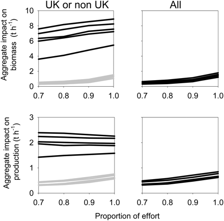
Estimated trawling impacts per unit time on benthic biomass (upper panels) or production (lower panels), as a function of the proportion of total trawling effort included in the calculation. Effort or value are expressed as a proportion of the total, and cells with the highest rank effort are included first. Left panels are for UK vessels (black lines) or non-UK vessels (grey lines), and right panels are for all vessels. Each line in each panel represents a different year.
Eleven Marine Conservation Zones (MCZs) proposed as part of a UK process in support of commitments made in the Marine and Coastal Access Act (Ashworth et al., 2010; Net Gain, 2011) fell wholly or partly in the study area. The combined area of intersection was 7254 km2. The proportion of fishing effort in areas proposed for designation ranged from 1.1 to 5.5% by year for UK vessels, from 1.3 to 2.1% non-UK vessels, and from 1.3 to 2.1% for all vessels. The mean sensitivity of habitats in MCZs was 9.5 years for biomass recovery time compared with 11 years for habitats outside (medians 11.7 years inside and 11.9 years outside, respectively) and 4.4 years for production recovery time in MCZs compared with 2.9 years outside (medians 5.1 years and 2.1 years).
The estimated impacts of beam trawling in areas proposed as MCZs are small in relation to the year to year variation in impacts due to changes in vessel activity and distribution. Predicted Bloss in proposed MCZs ranged from 0.7 to 2.7 × 10³ t for UK vessels (1.3–4.4% of Bloss in AE100; range reflects variation among years), from 3.6 to 4.2 × 10³ t for non-UK vessels (2.2–2.7%), and from 3.7 to 4.3 × 10³ t for all vessels (1.8–2.2%). Interannual ranges in Bloss in the study area were 57.6 × 10³ t for UK vessels, 45.1 × 10³ t for non-UK vessels, and 67.3 × 10³ t for all vessels; equivalent to at least 21, 10, and 15 times the maximum Bloss for UK, non-UK, and all vessels, respectively, in proposed MCZs. Bloss in areas not proposed as MCZs was 47.2–104.8 × 10³ t for UK vessels (range among years), 135.6–180.4 × 10³ t for non-UK vessels, and 167.2–234.5 × 10³ t for all vessels.
For production, estimated Ploss in proposed MCZs was 0.2–1.1 × 10³ t year−1 for UK vessels (1.5–7.1%), 1.8–2.3 × 10³ t year−1 for non-UK vessels (2.3–2.8%), and 1.9–2.5 × 10³ t year−1 for all vessels (2.1–2.6%). Interannual ranges in Ploss were 18.6 × 10³ t year−1 for UK vessels, 15.6 × 10³ t year−1 for non-UK vessels, and 27.4 × 10³ t year−1 for all vessels, equivalent to at least 17, six, and 11 times the maximum Ploss for UK, non-UK, and all vessels, respectively, in proposed MCZs. Ploss in areas not proposed as MCZs was 11.5–30.2 × 10³ t year−1 for UK vessels (range among years), 73.0–88.6 × 10³ t year−1 for non-UK vessels, and 82.5–110.0 t year−1 for all vessels.
Having estimated fishing effort and impacts on B and P in the areas proposed as MCZs, we estimated the impacts of the same amount of effort on B and P in the least intensively trawled areas of the fishing grounds (cells included by rank order of effort from low to high until the cumulative effort in the defined ‘margin’ equalled measured effort in all MCZs). This approach was used to compare potential changes in B and P in response to any management measures that (i) excluded vessels from MCZs and (ii) limited fishing grounds to core areas; based on the assumption that the same amount of effort was excluded in each case. Effort in the defined ‘margins’ led to mean estimates (among years) of Bloss that were 1.5-, 5.4-, and 5.6-fold higher than Bloss for the MCZs, for UK, non-UK, and all vessels, respectively. Equivalent figures for Ploss were 0.7, 1.8, and 1.8. Thus, in all but one case, exclusion of effort from margins was predicted to lead to larger increases in B and P than exclusion of the same effort from the proposed MCZ.
Discussion
Assessments of the interactions between fishing fleets and habitats can support informed debate on space allocation between fishers, other users of the marine environment, and managers. Even though the entire fishing grounds of UK and non-UK beam trawlers were not considered, the fishing grounds in the study area consisted of relatively small, intensively fished core areas, and relatively large, infrequently fished margins; consistent with previous analyses of entire fishing grounds for a range of UK vessels (Jennings and Lee, 2011). For both UK and non-UK vessels, the small proportion of total effort in the margins of the fishing ground (areas in AE100 but outside AE90) accounted for a relatively small proportion of landings weight and value but a relatively large proportion of the total impact on seabed habitat.
Beam trawling accounts for the majority of towed gear effort in the study area (ICES, 2008), and is thus expected to account for the majority of the total fishing impact on seabed habitat (e.g. Bergman and van Santbrink, 2000). Trends in effort and effort distribution, interactions with habitat, and impacts in the study area are not necessarily consistent with trends in the entire fishery as plaice and sole fishing grounds extend well to the east of the study area and outside UK territorial waters (Piet et al., 2007; ICES, 2008). However, the interactions and impacts in the study area are important to the extent that they affect the UK spatial planning process and the development of MCZs. Further, even though the entire plaice and sole fishing grounds do not lie in the study area, the proportions of these grounds that intersect the study area comprise core areas that account for a large proportion of total effort and relatively extensive margins that account for a smaller proportion of total effort; a pattern consistent with the structure of entire fishing grounds described for several fishing fleets by Jennings and Lee (2012).
Variations in the footprint of the beam trawl fisheries from 2006 to 2010 had large consequences for habitat interactions and impact. These consequences were much greater than any of those that would result from restrictions on beam trawling in all the proposed MCZs. Thus the effects of interannual variations in the intensity and distribution of UK, non-UK, and all effort in the study area were estimated to exceed the effects of excluding trawling from MCZs by at least 21-, 10-, and 15-fold respectively. These estimates would, of course, be conservative, since we did not assess the additional impacts of any displaced effort that remains in the study area (for an analysis of the potential effects of effort displacement on overall fishing impacts on North Sea seabed habitats, see Hiddink et al., 2006b).
Analyses that compared the effects of removing the same amount of trawling effort from (i) sites proposed as MCZs and (ii) from the margins of fishing grounds showed that, in all but one case (UK vessels, impact on P), the exclusion of effort from margins led to larger increases in total B and P than exclusion of the same amount of effort from MCZs. Since the state of the seabed, here represented by B, has been a greater focus of conservation efforts than processes, represented by P, removal of effort from the margins of fishing grounds has greater overall conservation benefit. This analysis assumed that effort is removed rather than displaced, but the negative effects of displacement are typically smaller when vessels are excluded from marginal areas where fishing effort is necessarily low (Hiddink et al., 2006b).
If policy commitments require that fishing impacts be reduced in the study area, either to meet specific targets [e.g. targets for achieving Good Environmental Status (GES) for ‘seabed integrity’ that result from the Marine Strategy Framework Directive (EC, 2008)] or ‘to reduce to a minimum the impact of fishing on marine ecosystems’ (EC, 2007), then changes to fishery management plans provide an existing and internationally coordinated mechanism that can achieve greater overall reductions in fishing impact than the exclusion of beam trawlers from proposed MCZ sites. Indeed, the positioning of any MPA in core fishing grounds can have a potentially negative effect, since the increased dispersal of displaced effort leads to greater overall impacts (Hiddink et al., 2006b).
Existing interannual variations in distribution and intensity of beam trawling are driven by a range of factors including regulations, the distribution and migrations of plaice and sole, and oil prices (Hunter et al., 2003; Hutton et al., 2004; Poos and Rijnsdorp, 2007; Gillis et al., 2008; Poos et al., 2010). The multiannual management plan for plaice and sole (EC, 2007) requires that fishing effort is capped at 2006 levels, even though the TAC changes. The North Sea plaice TAC fell from 57 441 t in 2006 to a low of 49 000 t in 2008, and rose to 63 825 t in 2010 (ICES, 2011). For sole, it fell from 17 670 t in 2006 to 12 800 t in 2008, rising to 14 100 t in 2010 (ICES, 2011). Although overall effort cannot rise with the TAC, spatial constraints on beam trawlers are relatively limited and the fishing grounds used are extensive and dynamic within the broad constraints imposed by fish distributions, access costs, fishery area closures, and management areas.
One stated objective of the multiannual management plan for plaice and sole (EC, 2007) is ‘to reduce to a minimum the impact of fishing on marine ecosystems’. This raises four issues. First, our results show that interactions with sensitive habitat and the impacts of fishing per unit effort are greater for UK vessels that fish to the north and east of the study area (predominantly targeting plaice) than for non-UK vessels fishing in the south (targeting sole and plaice). This conclusion is predicated on the reasonable assumption that any differences in the rigging of beam trawls, and their consequential effects on the size-related mortality of benthic animals per unit swept area, do not override the differences in impact that follow from differences in the sensitivity of fished habitat. If the conclusion holds, would the stronger habitat interactions and higher impacts per unit effort of the UK vessels be consistent with minimizing impact if they have an option to fish elsewhere? Second, a mechanism to ‘reduce to a minimum the impact of fishing’ has not been developed or defined, but, having shown that the large and lightly fished margins of the fishing grounds contribute so much to total impact, there would be a relatively large reduction in environmental impact by defining fishing grounds that only included the existing core areas (e.g. AE90). What would be the consequences of restricting fishing effort to areas smaller than AE100, in terms of interactions between vessels, interactions between vessels and other sectors, fishing costs, and fishing opportunities (to catch the available TAC)? Third, is minimizing impact rather than avoiding unsustainable impact an appropriate aim of a management plan? If not, then what is the target for acceptable maximum impact? Finally, how do the reductions in impact that can be achieved by managing the extent of fishing grounds compare with those that might be achieved through gear modification or gear changes, what are the relative costs of these approaches, and how might they complement each other?
The management plan caps fishing effort at the 2006 level, but our results suggest that this will only make a small contribution ‘to reduce to a minimum the impact of fishing on marine ecosystems’. Accepting the words of the plan at face value, an additional and arguably more effective approach for reducing impact would be to limit the spatial extent of fishing grounds using measures or incentives that reduce effort in the margins. This would achieve the greatest reduction in seabed impact for the smallest reduction in effort. Currently, management plans usually specify fishing grounds at the scale of ICES divisions or areas, but these resolutions would be too coarse to define efficiently grounds of a lesser extent than AE100. Finer resolutions and more precise boundaries would be required to define fishing grounds that maximize reductions in seabed impact while minimizing the loss or displacement of effort.
Some potential advantages of defining fishing grounds based on core areas are that the approach would (i) minimize the probability of additional fishing impacts on seabed biomass and production; (ii) clarify the extent of fishing grounds in negotiations with other sectors and in marine spatial plans; and (iii) reduce interannual variations in fisheries footprints and their consequent effects. Two disadvantages of defined grounds are that they (i) limit options for the industry to respond to changes in fish distributions, costs, and market opportunities in the short and long term; and (ii) potentially increase interactions among vessels. To allow for more flexibility in location choice, an environmental impact assessment-type process could be considered to allow for areas of fishing ground to be ‘traded’ for alternative areas of equal or lower sensitivity, and/or the location of fishing grounds could be reassessed at intervals of a few years.
Changes in environmental policy, moves to spatial planning, and growing demands for marine space make it likely that past freedoms of sectors will be curtailed. An approach to defining fishing grounds that excludes some of the margins of existing fishing grounds maximizes opportunities for fishing within these constraints while contributing to a reduction in environmental impact that can be greater than that achieved by other measures such as MPAs. The approach also allows international fishery management to take a proactive and positive role in planning rather than responding to multiple national claims. Given that the management structures to implement fishery management plans are already in place, they may provide a more cost-effective way of minimizing the overall environmental impact of fishing than MPAs in many circumstances. The identification and management of fishing grounds in a spatial planning framework is also a ‘bigger picture’ approach, that considers the impacts of fisheries on the overall state of the environment rather than local environmental gains that might be achieved in MPAs despite costs elsewhere (Hiddink et al., 2006b).
We made a number of assumptions in the analysis that influence estimates of activity, sensitivity, and impact, but we do not believe that the assumptions affect our general conclusions. Habitat sensitivity was measured as the recovery time of biomass or production after trawling. Biomass and production provide basic metrics of seabed state and a seabed process, respectively, but are not metrics of other attributes, such as species diversity or uniqueness that are also regarded as relevant in a policy context (e.g. EC, 2008). The model used to assess sensitivity makes several simplifying assumptions. Following model validation, sensitivity analysis, and a review of these assumptions, Duplisea et al. (2002) and Hiddink et al. (2006) concluded that the model effectively predicts observed differences in benthic community structure among areas subject to different fishing intensities in the study area. The model is not appropriate for benthic habitats that are dominated by emergent structural fauna, but our general approach could be applied to these habitats in other regions by using proxies for sensitivity [e.g. estimated recovery times of biota following trawling based on meta-analysis (Kaiser et al., 2006; Foden et al., 2010)]. For UK vs. non-UK comparisons, the impacts of each group of vessels was treated independently (additive effects of the vessels were assessed in the analysis for ‘all vessels’). Estimates of impact for ‘UK’ and ‘non-UK’ were not additive because the relative impact of a given group of vessels at a given time and location will depend on preceding effort at that location. For this reason, only the impacts for ‘all vessels’ are indicative of true, as opposed to the potential, impacts in the study area. The process of linking VMS effort to landings and value for the UK vessels assumed that landings and value on a given fishing trip were proportional to VMS effort at the subrectangle scale. This ignored heterogeneity in catch rates and catch composition that are known to exist but cannot be documented with available data. Other caveats associated with VMS analyses based on 2 h position and speed records are discussed in detail by Lee et al. (2010) and Jennings and Lee (2012). Of particular relevance is that an analysis based on allocating positions to grids leads to estimates of trawled area that decrease with trawling effort, thus underestimating the true extent of margins. For this reason, our estimates of trawling impacts in margins are conservative, and the effects of removing effort from margins will be greater than estimated. In future, the scope for VMS analysis will increase as the time-series extends, smaller vessels are included in monitoring, and databases improve to allow matching of more VMS and logbook records (e.g. Gerritsen and Lordan, 2011). Further, landings and value data could be assigned directly to the smaller grid cells used for the VMS analysis once electronic logbooks are widely adopted. Such developments will provide better information on track records, interannual variations in impact, and responses to management regulations.
With few notable exceptions, practical efforts to address environmental conservation and fisheries management issues in Europe are largely independent. In part, this is because many spatial plans and protected areas are being progressed nationally, while offshore fisheries are managed internationally. However, the political drivers for dealing with environmental and fisheries management together are strong, since the Marine Strategy Framework Directive of 2008 (EC, 2008) requires that the ‘collective pressure’ of human activities is kept at levels compatible with the achievement of GES, where two of the descriptors of GES relate to seafloor integrity and biodiversity. The Common Fisheries Policy (CFP) is identified in the Marine Strategy Framework Directive as the primary instrument to manage fishing pressure to achieve GES. Nationally, the interplay between fisheries management and conservation policy is not so clearly defined, although EU member states currently need to use the CFP if they wish to exclude fishing from any MPA outside the 6 and/or 12 nautical mile national limits.
If fisheries managers are to support the achievement of GES for ‘biodiversity’ and ‘seabed integrity’, then two questions have to be addressed pending the final decisions about the indicators and targets for these descriptors: what is the minimum level of fishing effort needed to take the TAC and how should it be allocated in space to minimize environmental impact? The missing link in the current advice is that TACs are specified but there is only broad guidance on where TACs should be taken (the main exception being when real-time and other fisheries closures are part of the management plan, e.g. Needle and Catarino, 2011).
In the North Sea and other areas where concerns about trawling impacts are raised, the fishing mortality rates and biomass of some fished species are not meeting agreed targets. As management measures are taken to meet these targets, reductions in seabed impacts may result if the responses of fishers lead to contraction of the area fished. An alternate approach is to manage the contraction actively, by linking reductions in target species' mortality to reductions in fished area, thus reducing impact at low additional cost. Of course, this option would not achieve representation of protection by habitat type, an often stated goal of MPAs, but if sufficient information on habitat type were available then management measures could be tailored/modified to address this. Further, although issues such as representation and connectivity may dominate plans to select MPAs, other more pragmatic criteria have been used in practice, especially when there are strong objections to proposed designations and MPA designs are not ‘optimal’ with respect to any sets of principles that are advanced.
In summary, fisheries regulations and fishers choices can lead to large variations in the overall impacts of trawling. Direct management of trawling footprints has potential to support the achievement of environmental objectives at lower cost than other management tools. Analyses that link trawling effort distributions, impacts, and sensitivity would enable managers to predict the implications of changing patterns of fishing impact when establishing spatial management plans and to identify and define fishing grounds that minimize the unwanted impacts of fishing. These approaches would provide a concrete step towards supporting the policy aspiration ‘to reduce to a minimum the impact of fishing on marine ecosystems’ and would allow fisheries management to make a greater contribution towards meeting existing fisheries and environmental policy commitments.
Supplementary material
Supplementary material is available at the ICESJMS online version of the manuscript and consists of the following. Figure S1 shows seasonal trends in effort, catch value, and habitat impacts. Figure S2 shows relative habitat sensitivity in core and marginal areas of fishing grounds. Table S1 shows estimated reductions in benthic biomass and production attributed to defined proportions of total beam trawling effort by UK and non-UK vessels. A short discussion of seasonal trends in the beam trawl fishery is included.
Acknowledgements
This research was funded by the UK Department for Environment, Food and Rural Affairs (Defra). The vessel monitoring systems data were provided by Defra in raw, uninterpreted form. The Secretary of State for the Environment, Food, and Rural Affairs does not accept any liability whatsoever as to the interpretation of the data or any reliance placed thereon.
References
Author notes
Handling editor: Verena Trenkel
